San Rafael needs a progressive after Nader Mansourian

First up: if you’re interested in becoming a new Director of Public Works for a small city, apply by the end of today. Downtown San Rafael, Image from  the Business Improvement District.

For years, San Rafael has been something of a mixed bag to Marin’s suburbanists. On the one hand, its downtown is the most transit-accessible places in the county. On the other, the network of one-way streets and pedestrian barriers – especially on Second and Third – have rendered large swathes of the city no-go zones for pedestrians.

With Nader Mansourian’s retirement as Director of Public Works in March, San Rafael has a chance to hire someone who makes moving people a greater priority. If I were a member of the city council, I would ask candidates the following questions:

1.       What do you believe the role of a city’s streets should be? The answer I’m looking for: for moving people, and for building the community's wealth. The answer I’m not looking for: to move vehicular traffic. The first answer indicates the candidate understands that traffic and street problems are more than just engineering issues around traffic flow. There are competing priorities for city streets.

The second answer indicates the opposite, that moving cars, regardless of the occupancy, is more important than pedestrian safety or encouraging more efficient use of the street network.

2.       What do you think of the NACTO standards? NACTO design guides have become one of the most important parts of building complete streets. They include scientifically evaluated standards for safe bike lanes of all types; for transit-only lanes; for arterial roads; and others.

Caltrans has endorsed NACTO's guides. Having a new director that embraces this shift is vital for the city.

3.       What do you feel the city can do to improve pedestrian safety? Roadways and pedestrian safety are more than simply a compact between people in cars and people on foot. Design can have a subtle and subconscious effect on driver and pedestrian behavior.

The most obvious results of Mansourian’s safety efforts are scores of Do Not Cross pedestrian barriers and the removal of the crosswalk at Third and Cijos. He largely didn't make use of the other, more subtle and effective tools in the toolbox.

San Rafael desperately needs a progressive in charge of its infrastructure, especially its streets. Mansourian was a highly effective engineer, but he was hidebound to outdated standards that run against the grain of modern best practices. San Rafael needs change. You should apply – applications are due at the end of the day.

Sausalito in a backwards fight against ferries

For years, Sausalito had struggled with its success. Tourists on rental bikes flood the town every summer, creating a logistical and transportation nightmare for the small city. Recently, attempts by the city council to cope with the challenge have been less about addressing the issue and more about resentment against tourists, cyclists, and the ferries they rely upon. The City Council looks set to vote its opposition to an expanded Golden Gate Ferry facility and has already expressed opposition to a National Park Service ferry to Fort Baker.

Background

Sausalito is part of the natural loop of bike-riding tourists to San Francisco: rent a bike, cross the Golden Gate Bridge, head down to Sausalito, hang out, then take a ferry back. Simple, easy. But downtown Sausalito is a tightly constrained place. Bridgeway, the only road running the full length through downtown, doesn't have the facilities to handle its bike traffic, and so it spills over onto sidewalks, rankling locals. According to Marinscope, some ferries have to leave for San Francisco half full because of the sheer number of people with bikes.

As far back as 2009 at least, the more colorful described these bike-riding tourists as "locusts." In 2015, conservative councilmember Linda Pfeifer proposed limiting the number of people on bikes from entering the city.

Sausalito isn't the only place with tourist problems. Tam Valley has been groaning under the weight of tourist traffic heading to Muir Woods along Shoreline Highway. Sharon Rushton, a political ally of Councilmember Pfeifer, has been fighting the National Park Service's proposals around the national monument for years, whether it has meant fighting shuttles, parking, or parking management.

Back to Sausalito

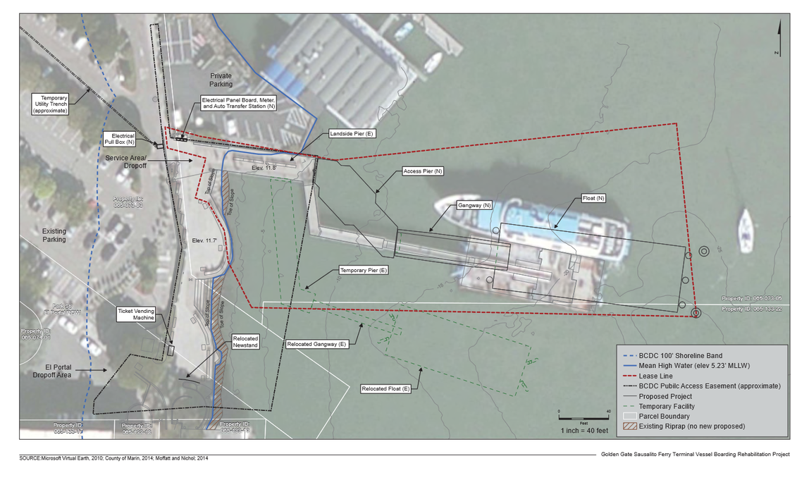
To help address the number of people taking the Sausalito Ferry with bicycles, GGBHTD has proposed expanding its Sausalito terminal.

The proposed ferry terminal redesign from the air.

According to planning documents (large PDF) the new terminal would allow a fully-loaded Spaulding ferry, which can accommodate up to 750 passengers with up to 100 bikes, to unload in 3 minutes and load in 6. This is a dramatic improvement over existing conditions, where ferries are reported to sometimes leave half-full.

As well, the new design would allow passengers with bikes to load simultaneously and separately from those without bikes, reducing some of the friction that causes delays in off-loading at San Francisco.

But the proposal has raised hackles with the council. Those opposed to the redesign aren't happy with the final pier's distance from shore and the amount of water covered. They'd like GGBHTD to begin regular dredging of the area so ferries could come closer to shore.

The existing ferry terminal.

The proposed ferry terminal, as seen from the nearby Yacht Club.

To my eyes, the new design looks only slightly more intrusive than the old; it's unclear to me why adding an additional and ongoing expense of dredging would be necessary. Perhaps a commenter could enlighten me as to the downside of the new design's size.

This is not the only ferry project that may happen around Sausalito.

A National Park ferry at Fort Baker?

Two miles south, the National Park Service (NPS) is interested in building a new ferry terminal at Fort Baker. While details are sketchy, the NPS has said the ferry would be operated by the same company that currently operates Alcatraz service. According to Marinscope, the terminal would only be used for "special events" and would not include a parking lot.

According to Brian Aviles, planner for the NPS:

The intent is to complement the programs at Fort Baker and perhaps allow people to visit Fort Baker without having to drive. We felt it prudent to investigate installing a gangway and float. It would function to link the main Alcatraz embarkation point to Fort Baker. (quoted by Marinscope)

According to the San Francisco Chronicle, this is part of a larger project to add ferry service to water-adjacent NPS sites around the Bay, including Rosie the Riveter National Historic Park in Richmond. It would allow NPS to focus tourist traffic towards ferry service rather than the current collection of ferries, shuttles, and parking lots.

While not part of the project's scope, Sausalito City Manager Adam Politzer finds the idea of NPS shuttles on Sausalito streets frightening:

Having a ferry terminal at Fort Baker, even just for special events, would create traffic on both Alexander Avenue and Highway 101, exacerbating an already intolerable traffic situation... The increased traffic would place strains of vehicle movement and parking. Adding shuttle buses to the mix would also increase congestion on busy Sausalito streets.

Councilmember Pfeifer adds:

It is pretty obvious what the strategic goal is... I can see over time they will be directing the overflow [from Alcatraz] to Fort Baker and shifting those folks to downtown Sausalito.

The concerns expressed by Politzer and Pfeifer echo Rushton's complaints about the NPS and Muir Woods. Through her organization, Sustainable TamAlmonte, Rushton and others have advocated to limit the absolute number of visitors to Muir Woods per year and has opposed efforts to expand local shuttle service, saying that such ideas amount to commercialization of the monument.

Yet this ferry concept seems to fit perfectly with Sustainable TamAlmonte's proposed alternative, which is point-of-origin shuttle service. In a 2013 letter to the Board of Supervisors, Rushton writes:

If an Independent Scientific Carrying Capacity Study on visitor load for Muir Woods and related parking & traffic proves the need for a more robust shuttle system, establish a Muir Woods Shuttle System (using small shuttle buses) that picks up and drops off Muir Woods’ visitors at regional points of origin (E.g. San Francisco, East Bay, and North Bay) and NOT within the Tamalpais Area Community Plan area.

Without a parking lot, the Fort Baker ferry terminal could only be a shuttle for tourists from San Francisco and never add to traffic congestion on Sausalito streets. Even under the most intense use of a ferry - the implementation of shuttle service - would likely only add 2 vehicles per hour per direction to Bridgeway, hardly a tipping point. And, by encouraging tourists to forego car rentals entirely, it might actually cut down on the amount of vehicular traffic within Sausalito.

Sausalito’s city council is standing in opposition to transit from two providers that could be vital to reducing congestion in their city and Southern Marin at large. The professed reasons to oppose either project – the scale of the GGBHTD proposal, traffic at the parking-free NPS proposal – don’t hold up to scrutiny.

Thankfully, neither proposal is likely to be seriously affected. GGBHTD may modify their ferry terminal design, but the project will go ahead when the council majority – with which Pfeifer generally does not vote – is satisfied with any changes. And the EIR commissioned by Sausalito on the NPS proposal may shed valuable light on the terminal’s impact and reiterate the baselessness of traffic concerns.

Sausalito and Southern Marin does have a serious tourist traffic problem, but opposing ferries and shuttles won't help mitigate the problem.

Ch-ch-ch-changes

Over the past month, I’ve been working hard on my historic railroad mapping project, which is doing well over on Kickstarter. For sale are also 12x12 to 24x24 prints of the Northwestern Interurban map. If there’s enough demand, when the store opens up in May I’ll also include prints of the Highway 101 Strip Map and, if the project ever finishes, the North Bay Bus Map. That’s not all I’ve been up to. I married a beautiful linguist, been accepted to graduate school, scrambled to find the money to fund said graduate school, and become involved to some degree in developing world urban policies. (Kinshasa and the Democratic Republic of Congo is an especially fascinating story.)

Of course, this has used up a great deal of time, and so I haven’t been able to update this blog as much as I ought to have. There is no shortage of issues to discuss, from the gorgeous new renderings of Whistlestop’s development proposal to Sausalito’s battle with transit, ferries, and tourists.

On top of all that, there is research out about the multiplier effects of transit-oriented design that I’ve been sitting on since February, a proposal for an on-street bike path from San Rafael to The Hub I’ve been sitting on since last year, and more. There’s so much to cover and so little time.

Marin County is fascinating not simply because of its place as my family home but also because its challenges are the challenges of suburbs around the country writ small. We avoided many of the problems plaguing many of America’s new suburbs but are reticent to tackle our own.

Next month, The Greater Marin will reopen on a new site, theGreaterMarin.org, advertisement-free and integrated with a store to purchase prints of the various mapping projects (the good ones) I’ve done over the years.

TGM has been on an unplanned hiatus, but I’m not going anywhere.

A reality check for Randy Warren’s climate change plan

A candidate for San Rafael City Council has a bold plan to cut transportation CO2 emissions: subsidize electric cars. While at surface it sounds reasonable enough, the plan would be expensive for little gain. Take a look at candidate Randy Warren’s platform and you’ll find, under the climate change header, a description for Operation New Leaf.

For all the theories about what we can do to reduce greenhouse gasses from cars and light trucks, the reality is that the plans are speculation and hope.  Let’s aim instead for guaranteed results.  I propose Operation New Leaf, a plan to provide incentives for our out-of-county workforce to purchase zero emission cars for their commute to San Rafael. This plan targets workers who have held a San Rafael job for at least one year and live at least 20 miles away. The city would negotiate special rates with San Rafael car dealers, from whom the cars would have to be purchased or leased.  Participating workers would have to make a good faith pledge to do their workday shopping in San Rafael, so we improve our local economy and recover some operating costs via related sales tax.  We would target up to a 50% subsidy to the workers, with proper safeguards.  We then need to line up sponsors, whether from MTC or the private sector (including the car manufacturers themselves as a pilot program).  This is a complex proposal that requires a city study group, and I will encourage such study take place.  But until our legislature has the guts to set a date for banning the registration of new gas-powered cars, Operation New Leaf would produce instant and certain results in reducing greenhouse gasses.

The Census doesn’t estimate the source of in-commuting jobs by city, but we can estimate. There are roughly 43,000 jobs in the city. Of Marin jobs, a quarter are held by workers in counties at least 20 miles away from San Rafael (i.e., all but San Francisco and Contra Costa). Proportionally, that means about 7,760 San Rafael workers live about 20 miles away or more. With that in mind, I estimate the cost of Operation New Leaf at around $97 million, not including the cost to move an additional 1,000 cars to the city’s job centers and store them once they get there.

Would MTC help? Likely not, given their pursuit of multi-modal solutions to transportation problems. Would Nissan help so they could promote their electric Leaf? Probably not enough to make the project affordable. Would a change in drivers’ shopping habits offset the cost? Again, probably not enough to make it affordable to the city. Leasing the vehicles instead of buying them outright might put the cost into a more-affordable area around $10 million per year, but that’s still far more than San Rafael could carry.

Equally as unaffordable are the consequences.

The cost to congestion would be enormous, given that this would be like closing a traffic lane on Highway 101. And the cost to our built environment would be high, too. San Rafael would suddenly need to find parking for at least another 1,000 cars per day [see update below], not to mention charging stations for not just these 1,000 vehicles but the 10,000 others bought by people who already drive to the city.

This might be net-negative in greenhouse gas emissions, provided increased congestion doesn’t make the situation worse, but it wouldn’t be a panacea. Electric cars in California emit the equivalent CO2 of a 70mpg gasoline car. BART, in contrast, emits the equivalent of around 940mpg. It would also put those currently taking transit to work into harm’s way (driving kills 35,000 people per year), and fight downtown San Rafael’s efforts to expand its walkable downtown east of Highway 101.

To reduce transportation greenhouse gas emissions, San Rafael ought to try to segment the travel market for trips under 2 miles, where most car trips are made. Some of those really are best done by car, but others are best done on foot or bike. How we build our roads and grow San Rafael should allow each mode to function best in balance with the others.

For walking, that means maintaining sidewalks and slowing down the perceived speed of cars, which can drive away foot traffic. For biking, it means building quality bike infrastructure that is safe for anyone age 8 to 80. For driving, it means encouraging people who don’t need to drive to leave the car at home and out of the way of other drivers. Even if a few percent of trips shift from car to another mode, that's often enough to unlock traffic flow.

Or, if San Rafael really wants to spend millions of its own dollars on transportation, it could build a comprehensive Class I bicycle lane network for the whole city and Ross Valley with money to spare. It could provide free transit passes to in-commuters, cleaning up traffic while also cleaning the air. It could buy 48 hydrogen fuel-cell buses for Golden Gate Transit, or (for less money) retrofit Marin’s entire bus fleet to run on compressed natural gas.

Operation New Leaf doesn’t solve any problems faced by San Rafael; quite the opposite, it spends millions to exacerbate its existing problems. And, far from providing "guaranteed results," it could add to congestion-related CO2 emissions, possibly even enough to offset the gains.

Electric cars are touted as the solution to our transportation emissions, but it ignores the other costs of pushing car-only infrastructure: parking, traffic, public safety, and car maintenance. The way to reduce Marin's greenhouse gas emissions is to diversify away from an automobile monoculture, not to deepen it. And, in the meantime, we'd solve our transportation problems, too.

UPDATE AND CLARIFICATION: Some questions have arisen as to why more cars would be on the road under this scheme. Roughly 11 percent of Marin's in-commuters take transit to work, and it's reasonable to suspect slightly more take transit to San Rafael given the presence of the transit center. By subsidizing car ownership, it's reasonable to assume a good chunk of them would choose to drive instead and add more vehicles to the city and Highway 101.

Where do the PDA funds go now?

The future downtown station area will need some work. Image from City of San Rafael. Now that the Civic Center Priority Development Area (PDA) has been rescinded, TAM is left with a bucket of PDA-designated cash and even fewer places put it. While Mayor Gary Phillips says downtown San Rafael’s PDA is a logical place to put it, none of the proposed projects in the area are at a stage where they need funding.

Part of the delay is due to San Rafael Public Works (DPW) Director Nader Mansourian’s reported insistence that any road alterations wait until after SMART starts service in 2016. As a result, anything that might disrupt a road’s or intersection’s capacity, or level of service (LOS) will have to wait until the needed capacity is known. That includes bike lanes, traffic lights, crosswalks, bus lanes, etc.

PDA funds must be dedicated to improving the transportation infrastructure within a PDA. While they can target projects outside of a PDA, the project must have a direct positive effect on transportation service within the PDA.

It’s up to the Council and staff to get a slate of needed improvements to the area, from the small to the large. Some possible proposals:

Study which projects in the Downtown Station Area Plan would and would not impact traffic. This is probably the most basic study that would need to be conducted, given that it will be three years before SMART runs and likely another year beyond that before traffic patterns start to emerge. This would give a slate of small projects that could be priced, studied, and built before the train.

Link traffic lights to the rail crossings, done in concert with SMART’s work on the rail crossings themselves. When trains start moving through downtown, they will need to coordinate with traffic flow By linking traffic lights to the crossings, San Rafael could prepare for the trains’ arrival today. The linkage will need to happen on Day One of train operations, and so cannot wait for traffic studies to even begin.

While they’re at it, link traffic lights to bus service. Buses currently crawl through downtown San Rafael, especially northbound trunk service like routes 71 and 101. By allowing traffic lights to sense approaching buses and turn green, a system called signal priority, San Rafael could improve speeds for all bus travelers and improve transit access to and through the downtown station area. While DPW will no doubt want a traffic study to find out precisely how the system should work after SMART, the study will only show how to tweak the system once SMART runs. Benefits could flow long before then.

Fix the Andersen Drive/SMART crossing. One of the principal barriers to getting SMART down to Larkspur is not the station or track but the at-grade intersection of SMART tracks and Andersen Drive. The angle of approach for the train is too shallow for state regulators and so will need to be fixed before the train can proceed south to the ferry terminal. Given that the problem was caused by San Rafael when they extended Andersen, it’s on San Rafael’s head to fix the $6 million problem.

Begin a comparison study of how people move through and shop in downtown. How do shoppers get to downtown? How many people move through downtown? This will give San Rafael planners a snapshot of how SMART and the Station Area Plan changes San Rafael and how to target improvements in the future.

The other pressing projects, even under-freeway parking garages (proposed by the Station Area Plan), will change traffic flow and so won’t pass Mansourian’s muster without a Council mandate. However, staff should draw up a decision tree and timetable for implementation of bike, parking, transit, and other traffic-impacting roadway improvements before SMART begins,

What else would be a good fit for TAM’s PDA-dedicated funds?

Note: I reached out to TAM to determine which of these projects are fundable with PDA money and which are not, but staff have been in a crunch time and haven't been able to answer. I'll post an update when they reply.

Regional democracy wouldn't pan out for slow-growth

Unelected bureaucrats want to impose their will upon us, cry critics of Plan Bay Area. Nobody chose their town’s representative to the Association of Bay Area Governments (ABAG), after all. We elected them to city councils, not the ABAG General Assembly or Executive Committee. Plan Bay Area, passed by these unelected appointees, then, is an affront to democracy and the fair people of the Bay Area. This is, roughly, also the central thrust of a Marin Voice piece by Susan Kirsch, head of Sustainable TamAlmonte spokeswoman for Citizen Marin and Friends of Mill Valley.

So why not elect them?

Intriguingly, there was a plan about two years ago to create just such a body. SB 1149, by far-East Bay senator Mark DeSaulnier, would have created the Bay Area Regional Commission, or BARC. The bill, which died in committee last year, would have had 15 members, each elected from a district of equal population. BARC would have rolled the powers of ABAG, the Metropolitan Transportation Commission (MTC), the Bay Area Air Quality Management District (BAAQMD), and the San Francisco Bay Conservation and Development Commission (BCDC) into a single agency.

A hypothetical BARC would realize significant savings by eliminating redundancies, have the legitimacy of being controlled by an elected body, and improve interagency coordination. Rather than passing Plan Bay Area through a body of officials elected to local government then appointed to regional government, it would have been passed by a body of officials elected to regional government full-time.

In case you’re wondering, a one-county-one-vote BARC would be illegal if the county representatives were elected. The Supreme Court ruled in 1989 that electoral districts of special areas, like a BARC, must be of roughly equal population. The only way for us to get one-county-one-vote is through appointed boards, which how ABAG currently does things.

But one gets the feeling Kirsch and other activists in line with her would not be so enthusiastic about it. Rather than emphasize local control, a regional elected body would put the emphasis on the region instead. On top of that, Marin wouldn’t even get their own elected representative, given its small population. It would have to share one with Sonoma.

The push by Kirsch and others is really for local control and local democracy, not a regional democracy. If Plan Bay Area had been passed by a hypothetical BARC, I can only imagine they’d say they we’ve been outvoted by the rest of the region. Had it been put to a plebiscite, they’d likely say the same thing. After all, for residents of Kirsch’s tiny Tam Valley it is their world. Why would they cede control to people in Gilroy and Fairfield who have probably never even heard of Tam Valley?

While I support BARC in theory, given the regionalist perspectives of the other counties, I fear that it would only further embitter isolationist Marin. And, while I support the idea of putting Plan Bay Area to a regional plebiscite in theory, I fear the losing side would not embrace the result as legitimate, whether it passed or not. On top of that, it wouldn’t really address Kirsch’s underlying concern: that Plan Bay Area is not good policy for Marin or anywhere.

The way forward in regional governance is one I’ve said before: for Marin to create its own subregion. It would be able to have direct control over its regional housing needs allocation (RHNA), focusing development into the towns or areas most willing and able to take it. It would take control out of the hands of the region and into the hands of Marin’s governments.

Putting more democracy into the system won’t help Marin find self-determination, nor will it help the region address the concerns Kirsch and others raise. Bringing affordable housing decisions to Marin, however, will at least get that part back into the hands of our own elected officials.

Politics threatens good policy in North San Rafael

There seems to be a majority forming on the San Rafael City Council to rescind the Civic Center Planned Development Area (PDA). At last week’s special session on the subject, three of the city’s five councilmembers (Mayor Gary Phillips, Councilmember Damon Connolly, and Councilmember Kate Colin) expressed opposition to the PDA. While each expressed their own reasons for opposition, most swirled around the idea that, if we keep the PDA, San Rafael will be obligated to build massive quantities of affordable housing in an area that cannot support it. Fortunately, this is simply untrue.

What would the PDA actually do?

PDAs are an investment vehicle originally created by MTC. Cities tell regional agencies where they plan to focus population and job growth, and the region earmarks regional transportation money for those areas. In Marin, MTC requires that half of those regional transportation funds go the county’s PDAs. The other half can go to transportation projects anywhere in the county. While there is some talk in Sacramento to channel climate change transportation funds exclusively to PDAs, that proposal has not been finalized.

To help guide local planners, each PDA has a different “place-type” designation, which provides nonbinding guidelines about residential density and the quality of transit service. North San Rafael is a Transit Town Center, which MTC recommends should have or plan for between 3,000 and 7,500 housing units.

But, as a nonbinding recommendation, there is no obligation on San Rafael to actually zone for or build the recommended number of housing units. Rather, the recommendation is there to help San Rafael planners craft a local plan, which was done with the Station Area and General Plans.

There is concern about CEQA streamlining for affordable housing projects within PDAs, but the state doesn’t obligate the city or county to loosen its own environmental review processes. If the city decides a project shouldn’t receive CEQA streamlining, it won’t. This, as the only non-funding legal aspect of a PDA, is still well within the control of the city.

So what is the fear?

Anti-development (“slow growth”) activists in North San Rafael are concerned that the PDA creates an obligation to the city to zone for thousands more housing units than it could actually support, clogging streets, stuffing classrooms, and putting people in harm’s way along busy, high-speed arterial streets. We don’t have the water, don’t have the class space, don’t have the road space, and don’t have the tax revenue to take in so many new people.

But the PDA doesn’t obligate a thing. Mayor Phillips Councilmember Colin had another answer to that. They said it would be dishonest to use a place-type with a higher housing guideline than could realistically be put into the area without adverse impacts to existing residents.

As a nonbinding guideline, then, it would make sense for the city to simply downgrade the PDA to a level that falls in line with the existing level of housing development.  In fact, this is precisely what Councilmember Andrew McCullough proposed, and is one of the optional resolutions for Monday’s council meeting.

Why would we want a PDA?

Because North San Rafael has over $25 million in transportation needs, and the city is considering raising a sales tax because it can’t fund its existing obligations. It needs some extra funds if it wants to improve the neighborhood’s roads.

In fact, one project is very likely to be funded with PDA money: the proposed improvements to the Civic Center campus. Without the PDA, the $3 million project will be ineligible for regional money, and TAM will be forced to shift those funds to another PDA in the county.

But beyond that, a theme of those who spoke in favor of the PDA was that the neighborhood was unfriendly and unsafe for people walking or biking. Given the relative lack of bike lanes, bad connections to regional and local transit, and missing or crumbling sidewalks, it’s a wonder people haven’t been killed. Drivers, too, need to battle with congestion. They have been patiently waiting for a new freeway interchange for years.

All this could be funded by regional transportation dollars, or would need to compete with projects in the rest of the county. The PDA, as a funding tool, would put these projects on a fast track for approval and funding. Removing the PDA would likely cut the neighborhood off for years.

Politics, not policy, is at work

So the PDA doesn’t obligate any development, doesn’t obligate any zoning, and provides a way to make North San Rafael safer for kids to walk to school and commuters to get to the bus. If the PDA does start to obligate the city to do things it does not want to do, or even if it’s threatened, the city could rescind the PDA with no problem at that point. So why is the council voting on Monday? Alas, it’s about politics, not policy.

It’s an election year. Councilmember Damon Connolly is running against Susan Adams and Councilmember Kate Colin is fighting for her seat against slow-growth candidate Randy Warren. The county’s slow growth movement has fought against PDAs as a proxy for their fight against Plan Bay Area.

By setting themselves up against the North San Rafael PDA, Connolly and Colin are betting they can inoculate themselves against attacks from that camp. At first glance, that seems like a safe bet. Polling from One Bay Area shows that those with anti-development sentiment are more passionate about the issue and are more likely to vote than their counterparts.

Yet they are forgetting that Marinites want choices in how they travel and how they live. It’s not as easy a sell on the campaign trail, but it would be the way for Mayor Phillips and Councilmember Colin to knock the wind out of the slow-growth lobby.

The best compromise is to vote for downgrading the PDA. While it won’t satisfy those who lead the movement, it will show that the council is concerned about density and height while balancing it against transportation improvements North San Rafael desperately needs.

A fragmented BABS is bad for the region

UPDATE: Bay Area Bike Share has confirmed that you can, indeed, dock bikes between any participating city. It's unclear why Peter Colijn was unable to dock his bike. UPDATED UPDATE: Well, the BABS website has been updated saying that San Francisco and the rest of the system are separate, in that you can't bike from SF to other parts of the system, nor vice versa. But if you wanted to, say, bike from San Jose to Mountain View, you could dock your bike.

It took less than a week for an intrepid bicyclist to decide it was time to ride a Bay Area Bike Share (BABS) bike from San Francisco to Mountain View. Given our region’s strong corps of Bicyclists, it was only a matter of time, really.

But when the bicyclist, Peter Colijn, got to Mountain View, he couldn’t dock his bike. It seems BABS has set up not just different clusters of stations, but different systems altogether, where bikes from different clusters won’t dock at another cluster’s stations. This does not bode well for BABS.

As BABS expands, the clusters will get close enough that users could easily ride from one to the other.  By splitting what purports to be a unified system into chunks, riders won’t be able to do what it clearly seems like they should be able to do: ride across city lines. It will make rebalancing more difficult in the future, too, as the bikes won’t be interchangeable with one another.

There is a simpler reason why this is a bad idea: people will do dumb and unusual things with BABS, and splitting the system up will exacerbate the consequences.

As a long-time observer of Washington, DC’s Capital Bikeshare (CaBi) program, which uses the same technology as BABS, I can say that I’ve seen just about everything. People take out their bikes for the day, lock them to bike racks, take them on the Metro, bring them into the office, and all sorts of other things you definitely shouldn’t do with a bike share bike. (CaBi has assured me and others in DC that they are very willing to cut overage fees, especially for bikes out more than 24 hours, when people didn’t understand the system.)

The same thing will happen in the San Francisco Bay Area. People will take the bikes on Caltrain, do long-distance group rides, and other things that will cost them a great deal in overage charges, often unwittingly. If users can’t dock their bikes in different cities, they’ll get double pain. Not only will they get hit with overage fees, but they’ll be stranded with the wrong bike in the wrong area.

I suspect BABS separated the systems to make rebalancing easier. There’s no way for a cluster’s bikes to migrate away from it, so each city keeps its “fair share” of bikes. But this doesn’t account for users’ creativity or lack of knowledge about the system.

BABS should give people allowance to do things outside how they want users to ideally use their system. Let the hardcore cyclists do their marathon runs and brag about them on Strava – it’s free publicity! Let the inexperienced and the tourist take the bikes on Caltrain or ride them from San Jose to Mountain View. It would be easier to pick up bikes that people ride to the “wrong” place on BABS’ own time than to force innocent users to travel all the way back to wherever they came from. It would certainly beat the bad the publicity of an angry customer who, quite understandably, thought that all BABS stations were the same.

I have an email out to BAAQMD, BABS’ manager, to find out which clusters are interoperable and which aren’t. A comment on Cyclicious says Palo Alto and Mountain View bikes are interoperable, but I don't know anything beyond that. See update above.

Bike share for the ferry terminals

Last week, Bay area Bike Share (BABS) launched to some fanfare. Caltrain commuters and residents in a few neighborhoods along the Peninsula and in San Francisco can now bike to or from transit, making the first and last mile a bit easier. Calls for a broader bike share program to serve the East Bay, more Peninsula neighborhoods, and the whole of San Francisco have risen ever since the limited scope of the project was announced.

Advocates should add Vallejo and Larkspur-San Rafael to their list. As the outer ends of the Bay Area’s ferry service, they desperately need some way to bridge that last mile. Bike share is how to do it.

Why ferries?

A chronic problem with ferry service in the Bay Area is the lack of bi-directional demand. Though many San Franciscans work in Marin and Solano, it’s tough to get reliable transit service to their employment centers. Golden Gate Transit buses depart hourly heading north, even in the morning commute hour. SolTrans buses don’t even offer reverse-commute service.

While there is ferry service to Larkspur and Vallejo, there aren’t many jobs within walking distance of the terminals. Driving, then, is often the only viable mode, closing off those jobs available from car-less San Franciscans.

BABS stations could change that.

In Vallejo, the principal would be similar to the Caltrain satellite systems, like in Palo Alto. Scatter a few stations around the downtown, with a large one at the ferry terminal, and you’ve created is an easy way for commuters to head to or from the ferry terminal without the need to drive or to bring their own bike.

In Larkspur, the ferry terminal’s distance from downtown San Rafael, the county’s employment hub, means a more creative solution is needed.

A large BABS station at the ferry terminal, another in Greenbrae, and a few scattered around downtown San Rafael would allow reverse-commuters to use it as their last mile and draw San Rafael into the mindset of San Franciscans as a place to go.

As a bonus, both the Vallejo and Larkspur-San Rafael systems would boost ferry access. In Marin especially, it would boost access to the ferry for SF-bound riders and overcome the terminal’s poor transit service.

And, for both systems, it would improve access to biking in areas that could use some alternative transportation.

The zoning board should not be our nanny

2701 Shattuck There’s an apartment building being debated in Berkeley, and it’s not a bad proposal. At 60 feet tall, it would be about as tall as other buildings facing Shattuck. 2701 Shattuck would include 70 studio apartments (PDF), ranging in size from 307 to 344 square feet. It’s close to UC Berkeley, walking distance to Telegraph and BART, and adjacent to major bus routes. It will be built on what is now a fairly ugly vacant lot, and contribute $1.4 million to the city’s affordable housing fund.

Fifteen neighbors nearby aren’t happy with it. They cite the height and the proximity to detached housing nearby, common stuff. But they also cite on the size of the units and the relative lack of activities in the neighborhood. A zoning commissioner, Sophie Hahn, concurred, comparing the units to “penitentiary housing” and said there wasn’t enough room for “intimacy.”

Though I don’t want to speculate more on the concerns of massing and proximity, the others strike me as a damaging sort of condescension.

When I choose where I want to live, I look at a number of factors: price, transit options, proximity to my friends, job, and favorite neighborhood. As a single person who spends most of his time out at work or at some other hangout, I’m not so concerned about my home’s size. I need a bed, a desk, and a place to make and store food. A studio apartment in the right location will do me fine.

I am representative of one particular niche of potential renters. Other renters will be more concerned about proximity to transit, others about price, and others will want the space to entertain. As we grow our cities, developers should have the flexibility to build units and buildings that cater to the various niches of the rental market. Not everyone wants to live on a Mill Valley hillside, and not everyone wants to live in a high-rise off the Embarcadero.

We have our reasons for choosing the places we do, but it’s the height of arrogance to assume that our preferences apply universally. So when citizens say that studio apartments are “a new style of tenement housing,” I get upset. And when a policymaker (Sophie Hahn) says of studio apartments, “It’s a bleak, lonely, unhealthy life that I would have a lot of trouble endorsing,” that offends me, because she thinks that about my life.

The purpose of any market is to allow people to make their own decisions about what they want. I think beef tongue is disgusting. I have no idea why anyone would want to eat it. I mean, there must be something wrong with someone who wants to chew on something that has the texture of their own tongue. I also hate cilantro; it tastes like someone made nausea into a flavor and called it an herb. But advocate to ban these foods? Limit them to certain designated Mexican restaurants, perhaps, Vietnamese restaurants be damned? Of course not; it's preposterous to even consider. I can make my own opinions without asking others to agree with me. That’s freedom.

So it’s not the place of any zoning commission to pass judgment on the lifestyles of the people who live in certain kinds of housing. Their purpose is to determine whether a project meets the zoning code, whether its visual and traffic impacts will unduly harm surrounding neighbors, and whether it will be a safe and sanitary place to live. Nor is it their purpose to determine whether a project is financially viable or not. It’s the developer’s job to determine that. And, in a free society, it’s nobody’s job but mine to determine whether my lifestyle is a bleak and lonely one or not.

Once government steps into personal preference, it becomes a nanny, tut-tutting our choices of home and neighborhood. Sophie Hahn, and the neighbors whom she agrees with, should stick to a critique of the building itself, not the people, like me, who they think are too depressed to live anywhere else.

Cross-posted with Vibrant Bay Area.

A new 101 bus map for a revised bus system

In case you missed it, Marin Transit, in partnership with Golden Gate Transit, has made some changes to Marin’s bus system. The changes to existing routes saved enough money that they were able to add about 15,000 more service-hours to the system, meaning people around the county have better transit. The changes inspired a second look at my 101 corridor bus guide, and the result is here.

101 Buses-Weekday 2013.08-x

While the guide, technically called a “strip map,” reflects the changes to bus routes, I’ve also added non-GGT and Marin Transit routes to the map. Greyhound’s once-per-day north-south Arcata-SF service, Sonoma County Transit’s express services, and Mendocino Transit Authority’s service from Fort Bragg to Santa Rosa all made it onto the map.

It’s much less Marin-centric as a result, but no detail has been lost. Instead, Sonomans can know their options, Marinites can know their options, and all users get an expansive view of where they can go by transit in the North Bay’s 101 corridor.

This is the sort of map GGT needs to have at every bus pad and every transit center along its route. I created the original 101 bus map because I couldn’t visualize how all the lines interact and work together, nor could I tell what buses served which bus pad.

My home church, for example, is located off Smith Ranch Road, so it’s off the Lucas Valley bus pad. Since the 49 is the only bus whose schedule said it stopped at Lucas Valley, I’ll probably take it, turning what should have been a 15 minute ride into a 35 minute tour of Terra Linda.

With this map, I know I can have take the 70, 71, or 80. On a weekday evening, I might take the 44. But the 49? While it does serve the bus pad, it’s a local bus serving Terra Linda and the Civic Center, so it’s not the best idea.

A pocket version will be available in the next few weeks.

A measure of Marin's development politics: Development

One Bay Area, the organization behind Plan Bay Area, surveyed the region's opinions on the built environment. What kinds of transportation investments do we want? What kinds of cities do we want to live in? What would get you to take transit or ride a bike more? Though the survey has problems, it gives us the most comprehensive look at the Bay Area's support for urbanism. Last time, we looked at Marin's support for regionalism. (There was a lively discussion on this post's Patch incarnation.) Though there was was strong support for the underlying assumptions around Plan Bay Area, Marinites were far more divided on these issues than any other county in the region. A large minority was strongly negative about any regional planning. Today, we examine Marin's perspectives on the specific policies that shape Plan Bay Area. As a reminder to readers critical of Plan Bay Area, this will not address the underlying policy successes or failures of Plan Bay Area, only the opinions of its assumptions and how local and regional plans match those opinions.

Survey responses

The survey asked people three questions about development policy. The first was about funding priorities, and it began, "Next I will read you a number of items that may be considered as part of this Bay Area plan. For each, please tell me whether whether funding should be a high priority or not a priority. Use a 5-point scale where 5 means 'High Priority' and 1 means 'Not a priority.'"

After a number of questions about transportation, the survey asked about the policy, "Provide financial incentives to cities to build more multi-unit housing near public transit."

The next questions were about support for policies, and they began, "Next I will read you a list of specific strategies being considered to reduce driving and greenhouse gases. Indicate whether you would support or oppose each using the same 5-point scale."

The two policies were, "Build more housing near public transit designed for residents who want to drive less," and, "Limit urban sprawl by requiring most additional housing and commercial buildings be built within current city or town limits."

On all three Marinites answered more negatively than the region as a whole, and neither opponents nor proponents make up a majority of opinion on any of the questions.

The first asks a question nearly mimics the rhetoric of development skeptics, and so is probably the best measure of their influence in the county. In response to the question of whether the region should provide subsidies to cities to build more multi-unit housing near transit, Marinites were deeply divided. Though 39.9 percent were in favor, fully 30.8 percent were opposed, with 28.9 percent in the middle. This is the most opposition to the program in the region, which was otherwise 51.2 percent in favor and 20.9 percent opposed. The standard deviation, a measure of disagreement, was 9 percent higher than the rest of the region, too.

xx

On the second question, Marin again bucks the region, though not nearly as much. On the question of whether you support building more housing near transit for those who want to drive less, Marinites were 59.7 percent supportive and 20 percent opposed, versus 65.4 percent and 12.1 percent, respectively, for the rest of the region. We also had nearly twice as many people answer that they were strongly opposed than moderately opposed: 9.5 percent versus 5.3 percent.

xx

On the final policy question, whether development should be limited to only areas within existing city limits, Marin again answers more negatively than the region as a whole, though here it has company. A strong minority, 31.2 percent, opposes this policy, the most in the region. Joining it are Contra Costa (29.7 percent) and Santa Clara (28.2 percent). This question also trigged a very strong negative response, with 18.7 percent reporting that they are strongly opposed. Intriguingly, Marin’s support lines up with the rest of the region exactly: 41.6 percent of the region and the county support this policy.

xx

I did not expect this last result. Marin’s urban growth boundaries are a cherished part of our civic lore, as the continuing success of Rebels with a Cause shows. Indeed, this is so unlikely I suspect the problem lies with the question.

“Limit urban sprawl” may have been interpreted as razing the suburbs, a fear I’ve heard in community meetings and read in online comments. The question also talks about additional housing and commercial buildings, which suggests new growth. The strong negative reaction may have been more against any new housing and commercial buildings, not just those outside of existing municipal boundaries. In any case, there is too much wiggle room in how one could understand the question to glean much useful information from it.

These responses reflect Marinites’ opinions about what makes a good home and a good town. A plurality thinks high-density transit-oriented development would ruin our town character (41.7 percent vs. 36.9 percent). A similar plurality would not move to a more densely-populated area to live near amenities (42.3 percent vs. 38.8 percent). On these questions, Marin is more strongly negative than any other county in the region.

How does our planning stack up?

Keep in mind that, although each of the policies addressed in the above questions has stronger opposition than anywhere else, they each have plurality or majority support. Even subsidized housing, which has the weakest support, has a 9 point advantage over the opposition. Where opponents find strongest ground is in home preferences. A plurality believes high-density development would ruin town character, and a plurality wouldn’t trade higher densities for more amenities. Combine the two measures (give people choice to drive less but don’t increase density) and you get a no-change, slow-growth status quo, which is what planners have largely given Marin in the past few decades.

Plan Bay Area, which encourages localities to focus growth by pledging to focus planning and transit funding, does not fit this status quo. While most of Marin got by on its RHNA mandates by pledging to zone for housing growth, very little of it was actually built in part because of a lack of investment from host cities. Focusing investment could mean real changes.

This is best seen in the eastern half of the Civic Center Station Area Plan. Planners and proponents wanted to focus growth into an area that would, they hope, give people a choice to use the car less. But, for some residents, four- and five-story buildings where now there are parking lots means living in a higher-density area at least some are trying to avoid.

The flip side is also true. While Marinites favor giving people a choice to live car-free or car-lite lifestyles, there is little support in city or county plans. In downtown San Rafael, Marin's urban core, new developments are subject to parking minimums, tight density limits, and inconsistent floor-area ratios. These restrictions discourage developers from creating apartments designed for those who choose to live car-free or car-lite. For example, a proposal for for-profit apartments by Monahan at 2nd & B streets was 10-20 units smaller than it could have been without those restrictions.

The Downtown SMART Station Area Plan gets closer to lifting these restrictions by eliminating density limits in favor of a hard height limit, but planners left parking minimums in place. Renters, whether car-free or not, will need to pay for a space in their building. Developers will need to dedicate floor space to parking instead of rent-paying uses, like apartments or retail.

The debate itself

They survey also begins to shine some light on the structure of Marin's development debate.

Rhetorically, opponents’ language (“high-density San Francisco-style stack-and-pack housing”) is ideally suited to play on Marinites’ general distaste for density. As well, the policy environment, with its focus on RHNA mandates and affordable housing, keeps the conversation on a policy with a meager base. Opponents will win as long as they can tie a development policy to RHNA, affordable housing, Plan Bay Area, and the like, forcing proponents to scramble to the defense of relatively unpopular policies.

Yet the broad popularity of subsidized housing and higher densities in the region at large means opponents have an uphill battle if they want to move beyond the development politics that has dogged Marin for the past three years.

I suspect that one reason for deepening divide in this policy area in Marin is that it is just incessant. Just as we start wrapping up one RHNA cycle, Plan Bay Area begins. Just as that is settling down next year, the next RHNA cycle will come about. Marin’s development skeptics rightly feel under siege, as every victory is fleeting.

Proponents, meanwhile, are destined to continue to lose as long as the conversation is about affordable housing and housing units per acre. Unfortunately for them, they’ll get no favors from the regional housing process, which will keep shifting the conversation back to opponents’ favored ground. Instead, proponents need to talk about choice and character. Urbanist lawmakers need to say, “We need to give choices to our young people. We need to give people the option to drive less.”

The right policy package could also cut the legs out from opponents’ ground. A for-profit-friendly zoning code, sold as bringing choice, town character, and less driving could get some easier play in town meetings. If passed, it would bake into the zoning code the growth RHNA asks for, rendering future development debates much less contentious.

The takeaway

If there is a theme to this data, it is that Marin is deeply divided on issues of development. Though, again, there are no areas where Marinites are more against than in favor of a policy, those on the negative end of the spectrum are rather more strongly negative, with more 1s than 2s, than those on the positive side are positive, with more 4s than 5s.

It doesn’t hurt that in the Bay Area as a whole, likely voters are more strongly negative on these issues than unlikely voters. While we don’t have data on Marin’s likely voters, the region’s broader trend seems to reflect what we see in the county: civically engaged and organized opponents against much less visible and seemingly rudderless proponents.

Overall, Marin has played to stereotype so far, at least to some degree. Its residents have strong views on development policy that are both more negative and more divided than those in the rest of the region. Intriguingly, this includes the rest of the North Bay: both Sonoma and Napa are more positive than Marin on development policy.

Of course, land use policy is only one side of the planning coin. Transportation policy is intimately linked with development policy, and will be discussed next time.

A measure of Marin's development politics: Regionalism

For decades, Marin has cultivated a reputation as a firmly anti-development county, most recently in vehement protestations against affordable and medium-density housing. This would certainly be a fair assessment if one simply attends or watches government meetings about development policy or read the IJ’s op-ed section. But survey data from One Bay Area shows Marin to be a much more nuanced, and rather divided, place. This is the first in a four-part series on One Bay Area’s (OBA’s) survey and will examine the survey’s shortcomings as well as Marin’s responses on questions of regionalism. Subsequent installments will address Marin’s views on development, quality of life, and transportation.

On the survey

One Bay Area interviewed respondents in all nine Bay Area Counties and released the cross-tabs back in June. While the survey as a whole was informative and solid, there were some questions that were poorly worded and so tested messaging rather than policy.

“Do you support reducing driving to reduce greenhouse gas emissions?” was my least favorite. The Bay Area is strongly liberal and firmly convinced in the reality of global climate change. Of course we want to reduce greenhouse gases. Tying driving to such an obvious outcome doesn’t allow urbanists, who seek to reduce driving for a host of other reasons, to know whether driving reduction can resonate.

Another, “Do you support expanding commuter rail, like BART, to the rest of the Bay Area?”, conflates BART with commuter rail. Rather than focus on our real commuter railroads – Caltrain, SMART, ACE, and Amtrak – the question brings it back to everyone’s favorite transit system. The extremely strong positive response to this question is useless to planners outside BART who need to gauge public opinion on the subject. While it would be informative to SMART planners to see if their advertising campaign is successful in Marin and Sonoma, Napa and Solano are considering their own commuter rail system using light rail technology. Gauging support for such a system would be invaluable.

Regional planning

Marin’s sharp divisions are first seen in a question with overwhelming support in the county: do you support a regional plan? Fully 81.5 percent of Marinites think it’s a good idea, with only 10.7 percent who say it’s not important.  However, Marin has a far higher rate of response for those who answered that it was not at all important than the rest of the region, 8.6 percent in Marin vs. 2.8 percent for the whole region.

We further deviate from the region when discussing priorities. OBA asked whether a regional plan should focus on the economy, the provision of housing and transportation for all, or the reduction of driving and greenhouse gas emissions. Marin sided with the rest of the Bay Area in labeling the economy as the top priority, but was the only county where a plurality of people put greenhouse gas emissions in second place, slightly ahead of housing and transportation.

Answers the question, Which part of the plan is most important to the bay area's future: Improving the local economy, reducing driving and greenhouse gases, or providing access to housing and transportation for everyone?

Asks what about the next most important priority. Notice here, Marin deviates from the rest of the region.

This is at odds with Marinites’ statements on the availability of affordable housing. Fully 67 percent of respondents said they believed the availability was either somewhat poor or poor. Only San Mateo residents were more negative on their affordable housing supply (71.2 percent). Perhaps some Marinites think that the lack of affordable housing isn’t a problem for solving. This sentiment has been expressed often in public testimonies: I scrimped and saved for a house in Novato even though I’d like to live in Tiburon. Why should someone else get taxpayer help when I got none*?

Marin is largely in line with the rest of the region on the subject of whether the region or local governments should plan development. Bay Area-wide, local planning wins out over regional planning by a large margin, 53.3 percent vs. 43.6 percent. Marinites responded 57.7 percent and 38.1 percent, respectively.

sss

The sharp disparity between answers to this question and answers to the first question – whether or not a regional plan was a good idea – implies that Bay Area residents have separated in their minds a regional plan from local planning. Though it would be reasonable to think that they perceive regional plans as coordinating documents and local plans as visceral zoning documents, there’s not enough data to be sure. They could equally have a classic not-in-my-back-yard sentiment: we need affordable housing, just not here. Further studies are needed to clarify just what people think they’re supporting and opposing.

These questions on regionalism begin to explain the unease and rancor in Marin’s development politics. Marinites have a small but determined isolationist streak, and they are a bit more concerned about environmentalism than equity. When issues of affordable housing come up, arguments about social justice and social equity simply won’t hit as hard in San Rafael as they would in San Francisco. And when issues of regional mandates arise, this crosses into dangerous territory for those who are opposed to regional coordination and regional development planning.

But we need to look at how Marinites respond to specific development policies, and we’ll tackle that next time.

*As an aside, all homeowners get taxpayer help in the form of federal and state tax breaks, from the mortgage interest tax deduction to the stabilizing influence of Proposition 13.

Cross-posted to Vibrant Bay Area and Patch.

Odd words from one of San Rafael’s council candidates

The campaign for San Rafael city council is starting to ramp up, with four candidates vying for two open seats. One of them, Randy Warren, has chosen to run on a platform of being a development conservative. Though not necessarily news on its own, his words on why he opposes affordable housing development shows that he doesn’t understand the politics and issues at hand. He still has a chance to catch up, but conservatives need a knowledgeable voice on the council, and right now he still has a way to go. From his announcement press release:

[Randy Warren] believes the city’s Housing Element is gravely flawed.  The proposed affordable housing could end up not going to needy Marin residents but instead to people relocating from other areas around the Bay whose vast numbers could shut out San Rafael’s poor. “We need good quality jobs to support a growing population, and there is no viable plan at present to do that. Wishful thinking is not enough. We need to avoid related increases to unemployment and homelessness, and the risk they present in wage deflation.”

Affordable housing

The purpose of affordable housing is to do what he says it will: help those who work in Marin but can't afford to live here find a home. I'm not a fan of the methods used by the state to promote affordable housing, namely the regional housing needs allocation (RHNA) process, but my problem with it has to do with its viability, not that it will do what it's advertised to do. Warren implies there will be a bait-and-switch, where we build housing for Marinites only to find them filled by folks from elsewhere.

There is a huge amount of demand to live in Marin. This is seen not only in recent price spikes in housing and rent costs, but in our massive in-commuting population. Marin gets 45,000 in-commuters every day, mostly from Contra Costa and Sonoma but also from San Francisco and Alameda. Studies have shown that they typically take lower-paying jobs, either as service workers (housekeepers, shop clerks) or other professions (teachers, low-level office workers). They simply can't afford a home in the county, especially if they're trying to move here now, and so they in-commute.

Affordable housing is designed to reduce that amount of in-commuting, decreasing their cost of commuting and reducing the pressure on our roadways, not just to support Marin's existing low-income residents who presumably already have homes.

Jobs

Even stranger, however, is that Warren, while insisting we don't build affordable housing for non-Marinites, expresses concern that we aren't creating enough jobs for a "growing population." If we don't, he warns, we'll get increasing unemployment, homelessness, and wage deflation. I'm curious where this population growth would come from if not from beyond Marin, and why they'd come here if they didn't have a job. Perhaps he's talking about Marin's children, but surely he understands that Marin's demographics are such that it won't grow without immigration. But let's set this statement aside for a moment and focus on the jobs themselves.

First of all, Marin already has more jobs than it has workers. While 45,000 people commute to Marin every day, only 42,000 commute from Marin. In San Rafael itself, which is where Warren should concern himself, nearly 70 percent of jobs are held by out-of-towners. Marin, and especially his city, have more than enough jobs to support their own.

The problem, at least in the county at large, is that a great many of these jobs are not ones that many Marinites want or can afford to take. If we wanted to grow our jobs base, we would need to boost the number of high-paying professional jobs. That would mean drawing on the economic strength of San Francisco, developing places that are conducive to start-ups and innovation. Better transit connections for the predominantly car-free San Franciscans, as well as small housing units to keep Marin's young singles in-county, are needed to attract those high-paying businesses to San Rafael.

Alas, Warren, according to the IJ, wants to remove the Downtown San Rafael Planned Development Area (PDA), the place that would be most conducive to creating such an urban job center. By removing the PDA he would put at risk the targeted transportation investments the area desperately needs: a new bus terminal, better bike lanes, better connectivity from the rest of Marin, San Francisco, and the East Bay. At the same stroke, he would make the area less attractive to new businesses that may want to come.

But Marin doesn't have an unemployment problem. In fact, it has one of the strongest job markets in the state. Homelessness, while a problem, is not due to a lack of jobs. It's due to a complicated web of issues ranging from a lack of mental health services to the inherent instability of homelessness itself. A strong progressive shift in the zoning code in larger cities to allow more single-room occupancy hotels (SROs) as well as for-profit, sanitary bunking situations (think something like a more permanent hostel) would go a long way to fighting the "homeless" aspect of homelessness, while better investments in city services would help alleviate the underlying instability and poverty.

As for his last statement, that a lack of jobs in a single city of 56,000 would result in wage deflation, it is such a leap that it is beyond me. San Rafael is part of a much broader region and county, and its job market is deeply integrated with theirs. As we already established, it is so integrated that barely more than 30 percent of its jobs are held by locals. It would take forces far beyond the scope of the San Rafael City Council to depress the city's wages.

Not a promising start

These are odd and troubling statements from a serious candidate for city council. Development conservatives deserve a strong and articulate voice to represent their interests, someone who knows how cities operate in the region's context. Warren misunderstands the purpose of affordable housing, does not grasp the connection between land use and transportation, and does not understand San Rafael's job market.

Though I disagree with the development conservative position on a number of fronts, a knowledgeable councilmember could provide a needed skeptical eye to staff reports. He or she would be a valuable force and help shift the power of San Rafael from its departments to the council. I'm concerned, however, that Warren would be less of a check and more of a contrarian and populist, asking questions for their own sake and grandstanding instead of leading. At worst, he would isolate himself and bring discord to what is currently a collegial and effective body. I'd hate to see the problems of Sausalito replicated in Marin's largest city.

But the race is still young, and perhaps Warren is just getting his campaign legs. Over time, I'm sure he'll release more statements and say other things that will help refine our understanding of his views. But this is not a promising start.

When transit affordability and convenience are at odds

Last week, an IJ editorial on pricing ferry parking took a cautious note. “The bridge board needs to maintain a focus on keeping the ferry affordable to all and a convenient and dependable way to get to and from work.” The IJ is concerned that charging for parking will make the ferry unaffordable. But the aim shouldn’t be more affordability; it should be for efficiency. And, the best way to manage a scarce resource efficiently, including ferry parking, is to put a price on it. It’s a basic principal of economics. Supply can meet demand only when the resource has the right price. Higher prices discourage consumers from using the resource and encourage producers from making more of it. When it comes to a relatively fixed resource (inelastic supply), like parking, the price just regulates demand.

In the real world, a price forces someone to consider whether that resource is actually worth paying for. Is a parking space worth $2? Those who answer no will either get to the ferry another way or take another mode of transportation to the City. This leaves room for others who are willing to pay but who couldn’t find a space before.

Here’s the neat thing. By putting a price on parking, suddenly accessing the resource, while more expensive, is actually more convenient and dependable. Today we have a shortage of spaces, and someone who doesn’t show up by 7:30am is probably not going to get a parking space. If the price is such that, say, 5 percent of parking spaces are free each day, that means there will always be parking available, even in the middle of the day.

The IJ should concern itself not with how cheap we can make a ferry trip but how efficiently we can manage the ferry’s infrastructure. Thankfully, GGT is concerned about this. So rather than spend tens of millions to boost the parking supply, GGT wants to regulate it with a fee. People can still get to the ferry for free if they want to, with a shuttle, foot, or bike, but there is room to spare there. If GGT wants to operate with efficiency, this is where people need to go.

Zipcar will be a boon to San Rafael

Zipcars Zipcar has made it to San Rafael, and that is absolutely wonderful news. It will make car-free living easier and opens up opportunities for the City of San Rafael to save money on its municipal fleet. It’s only three cars so far, but for downtown residents that may be all they need.

Zipcar works on a subscription model. Light users pay an annual membership fee as well as rental cost per hour or per day, which are different depending on which car the user rents. Heavier users pay a monthly fee, no annual fee, and have lower hourly fees. Organizations, including universities, can also sign up, which is especially useful for businesses whose employees tend to travel a lot during a workday, though with only three cars available it wouldn’t be the most reliable service just yet.

For this, Zipcar subscribers don’t just get access to a car. It covers the cost of gas, insurance, maintenance, replacement, and the home parking space. So while the up-front costs seem steep at first, the end result is that users often end up paying less than they would by relying on their own car.

Yet despite that, these up-front costs do change the behavior of members (PDF). Zipcar subscribers have a barrier, albeit a short one, to using a car. Rather than simply hopping in the family sedan to drive to get a haircut, Zipcar members need to reserve their car for a selected amount of time, and they immediately see how much that trip will cost them. Maybe the trip would be worth it by car, but it turns driving into a conscious choice rather than a default alternative. As a result, use of modes other than driving increases among members.

For planners and developers, this means drivers don’t need as much car space. Not only will they not be on the road as much, but they also won’t need to park in as many places and they won’t need their own personal parking spot. Zipcar’s spot, shared with others, will be enough. So a new housing development with a lot of Zipcar members won’t need as much parking, and a city with a lot of members won’t need its roads to be quite as wide.

This behavioral shift isn’t unique to Zipcar, of course. Car-sharing services from Avis and Budget, as well as standalone services like Car2Go, are just as likely to change how people drive.

If San Rafael wants Zipcar to expand, the city should allow developers to cut parking requirements from their projects if they host car-sharing cars or subsidize membership for their residents. This would build a client base for Zipcar or its competitors while also reducing the number of cars in our parking lots and on our roads.

In short, Zipcar’s entrance into the San Rafael market is a Very Good Thing. Here’s hoping they’re here to stay.

The kids want Marin but not the car

Star-spangled banner The media was abuzz last month with news that the country is driving less than we have since 1996 and a report find that this trend will likely continue for at least another 30 years. Simultaneously, reports of housing preference finds that Americans increasingly want walkable, bike-friendly places to live. Both trends are most pronounced in Millennial and Boomers, the two largest cohorts working their way through our demography.

While most of the country's suburbs grapple with some seriously car-centered places that are rapidly losing value, Marin is a special case. Our network of walkable town centers is precisely what people are looking for. They provide independence the sprawl of other places can't. Even our arterial roads (mostly) have sidewalks, an amenity other cities dream of.

But we do need reform to capture this market, or Marin risks losing its children.

The push against driving

For the last 8 years, travel patterns have been shifting dramatically in the United States.

Since 2005, vehicle miles traveled - how many miles Americans drive - has been in decline. According to USPIRG, Americans now drive about as much per capita as we did in 1995 and as much overall as we did in 2004, while Californians have returned to 2005 and 1995 levels, respectively. Nationally, 16 to 34-year-olds drove a whopping 23 percent less in 2009 than they did in 2001.

Taking its place have been bicycling and transit, the use of which has climbed to record levels. Bicycling rates are tough to measure, thanks to very low starting numbers, but at least in San Francisco it grew 71 percent from 2006-2011. Easier to measure is the growth in transit usage, which is up 12 percent since 2002 and is now at a level similar to the 1950s. Young people, meanwhile, are taking transit for 40 percent more miles than their age group was 8 years ago.

USPIRG thinks this trend will continue, as the number of teenagers and young adults with drivers' licenses has declined significantly - to levels not seen since the 1970s - and shows no sign of abating. Consumer surveys show little interest in driving or cars among the young, with most viewing car ownership as a burden instead of a freedom. Instead, mobile devices have become symbols of freedom and status. Even AAA admits that any operation of these devices in a car, even by voice, is incredibly unsafe.

This shift in preference marks a significant difference of opinion from their parents' generation, which saw cars as signs of adulthood, freedom, and status. However, even those Boomers are starting to drive less. As they retire, they'll be able to cut the daily commute. And, over the next 20 years, more and more will age out of driving. This will further depress our VMT.

The push for walkability

Though many have gone through an urban phase before decamping to the suburbs, no modern generation has so embraced the city as the Millennials.

Across the country, this preference has shown up in price spikes around downtown cores, some of which have been in decline for decades. And it's not just the big name cities, either. While Detroit, Washington, and New York get headlines, places like Kansas City, MO, and Charlotte, NC, are seeing their downtowns' fortunes revive.

Driving the demand for city living is demand for high access by foot and bike to jobs, shops, and services. Though some love the bustle of the city, others just want the pleasant walk to the store, whether in a city or a suburb. Marin's town cores offer the balance of city and suburb that is all too rare outside New England.

Yet the continued focus on drivability over biking, walking, and transit puts a damper on Marin's ability to capitalize on this natural advantage. Rather than expand our town centers, we allow them to be islands of walkable living in a sea of pedestrian-unfriendly arterial roads. We value them, true, but we keep them in a box.

Instead of just preserving them, we ought to allow them to expand. Why should downtown Mill Valley be contained north of Sunnyside? Or downtown San Anselmo remain a 6-block strip along San Anselmo Avenue? Only Fairfax has expanded its downtown zone, replacing all its parking-heavy Highway Commercial zone with Downtown zoning.

Yet even within town cores, housing for singles - one bedrooms and studios - are strongly discouraged by a potent mix of parking minimums and density limits. Between town cores, the bicycling infrastructure needed for the most utilitarian trips - with cargo bikes or small children - is practically nonexistent.

Does this mean the end of the single-family detached home in Marin? Hardly. Though the more strident opponents of change in Marin claim any change means wholesale demolition of car-centric neighborhoods in Marinwood and Novato, there is still absolutely a place for them in the housing mix. Rather, what Marin needs is more diversity of transportation and housing options, not less, as has lately been the case.

If Marin wants to keep the residents that made the county a counter-culture mecca while attracting a new generation to a quieter alternative to San Francisco and Oakland, it will need to address this shifting reality. Eventually the Boomers will be unable to or unsafe to drive (asking them to purchase a self-driving car is simply outsourcing the problem), and the Millennials that should take their place will want better bike lanes and better transit options.

If we don't adapt, Marin risks becoming an exclusive enclave for the rich and retired, hardly a fitting end to the hippies who put Marin on the map.

GGT offers a thin lifeline in the BART strike

BART is on strike. I’ll spare you the gory details of why, as they’re covered much more extensively in other news media. However, now’s a good time to refresh minds about bus service through Marin. Though not ideal, it could be better than nothing for those who can get to Richmond or Del Norte BART stations. GGT routes 40 and 42 head to San Rafael, where a commuter can transfer to San Francisco-bound 27, 44, 70, 80, and 101. If you don’t want to wait, or if you think you’ll get lost in the crowd, you can head down the freeway on routes 17, 36, or 71 to one of the other commuter lines. As usual, pack the 101 service pocket guide.

The thing you probably won’t want to do is head to the Larkspur ferry. Parking is cramped as it is, and direct bus access is minimal. If you insist on a ferry, get on almost any bus heading south (17, 27, 36, 70, 71, 80) and hop off at the next stop. You have a ¾ mile walk from there. That, or drive to the ferry before 7am.

GGT has a much more extensive listing of how to get to SF. The fastest way may be to take a commuter bus from north of San Rafael so as to avoid the general traffic lanes through as much of Marin as you can. However, south of Marin City, the HOV lanes end and you'll get stuck in traffic. At least you can sleep through the stop-and-go.

Good luck out there. It's brutal.


Personalized mapping

Transit maps in Marin are, well, not very good. Especially for the uninitiated, they can be confusing spaghetti. About a year ago, I was contacted by a young man in Novato who had his drivers' license suspended for some reason and wanted to know how to get around to his destinations. He went to school in College of Marin, worked in Petaluma, and hung out with his friends in the East Bay. How was he supposed to get out of Novato without a car?

After an abortive attempt at a Novato spider map, I realized all I needed were the various connections between the destinations so he could know exactly how he could get from A to B without all the mess of geography. The map below is the result.

GGT Novato-2

It's simple, so it doesn't include things like frequency or span of service. Instead, I wanted to show how to get from place to place, major stops, and where those routes went after transfer points and destinations, without all the fuss of a more detailed map. Were I to make this again, I would probably place 49/49K to the west of the 101 corridor north of Ignacio and east of it to the south to reflect actual geography, but as it stands I think there's enough hints for the user to see where the bus goes.

I've never followed up with him to see how it went, though he seemed pretty excited to see it. Perhaps it will be of some use to you as well, as it's now up in the Map Room.

Quiet and Safe San Rafael gets it wrong on density

A few weeks ago, Quiet and Safe San Rafael (QSSR) published the claim that 79 units per acre, zoned for potentially proposed for in Terra Linda*, is more dense than Manhattan or Hong Kong. Though they are technically correct, QSSR wildly misinterprets the concept, the data, and ignores the density already in our midst.

Density limits

A density limit in Marin restricts how many units can fit on the parcel as measured in acres. 2 units on a quarter-acre parcel works out to 8 units per acre (2 divided by 0.25 equals 8). This doesn't include the street, parks, commercial development, or anything else beyond the building's parcel.

I don't know how Hong Kong does their density limits, but Manhattan doesn't usually have per-unit density limits. Instead, New York limits how much floor area a building can have (a measure called floor-area ratio, or FAR, if you're wondering). Again, this is based on the parcel, not the supporting infrastructure or all the other buildings.

The danger with measuring densities at a municipal level, as QSSR has done with Manhattan and Hong Kong, is that it does include all the rest of the city. It's like measuring the size of a house and calling it all a bedroom. It is disingenuous to compare that to the parcel-based densities used by San Rafael.

So while it's true that Manhattan averages 58 units per acre, higher than Terra Linda's allowed 79, that includes Central Park, Times Square, the avenues and streets, the docks, ferry terminals, office buildings, plazas, schools, police stations, City Hall, the UN, the New York Stock Exchange, and all the other things that aren't housing on that island.

Rafael Commons

That's ridiculous. Using San Rafael's measuring system, a 20-story tower in Manhattan would average to 800 units per acre, far and away higher than Terra Linda's 79. There's a three-story senior home, San Rafael Commons, that hits 90 units per acre. Is it "more dense than Manhattan"? Not in any meaningful sense.

This exposes the danger of using density as a proxy for character, as it doesn't measure anything about that. Character comes from a building's form: how tall it is, how far back it's set from other buildings or the street, etc. A single-family home can fit a second unit in the back, which doubles the parcel's density. A three-story building could be filled with two-bedroom apartments and be low density, or be filled with studio apartments and be high density. It wouldn't change the building's visual impact.

Whether QSSR tried to be deliberately misleading or not, it is clear they are trying to stir up fear of tower blocks along 101. There are legitimate things to worry about in Plan Bay Area and legitimate things to critique. It's truly unfortunate this activist group has chosen to focus on the ridiculous instead.

*Update and Correction: The intro misstated the current zoning and planned zoning and density around the Civic Center SMART station. Current zoning tops out at 43 units per acre, depending on where one looks. San Rafael's Station Area Plan calls for densities "above 44 units per acre", while the proposed Transit Town Center PDA calls for zoning to accommodate 20-75 units per acre. QSSR's number comes from the average of all PDAs in the Bay Area, which is not applicable to any individual PDA like the Civic Center area in Terra Linda.