Where do the PDA funds go now?

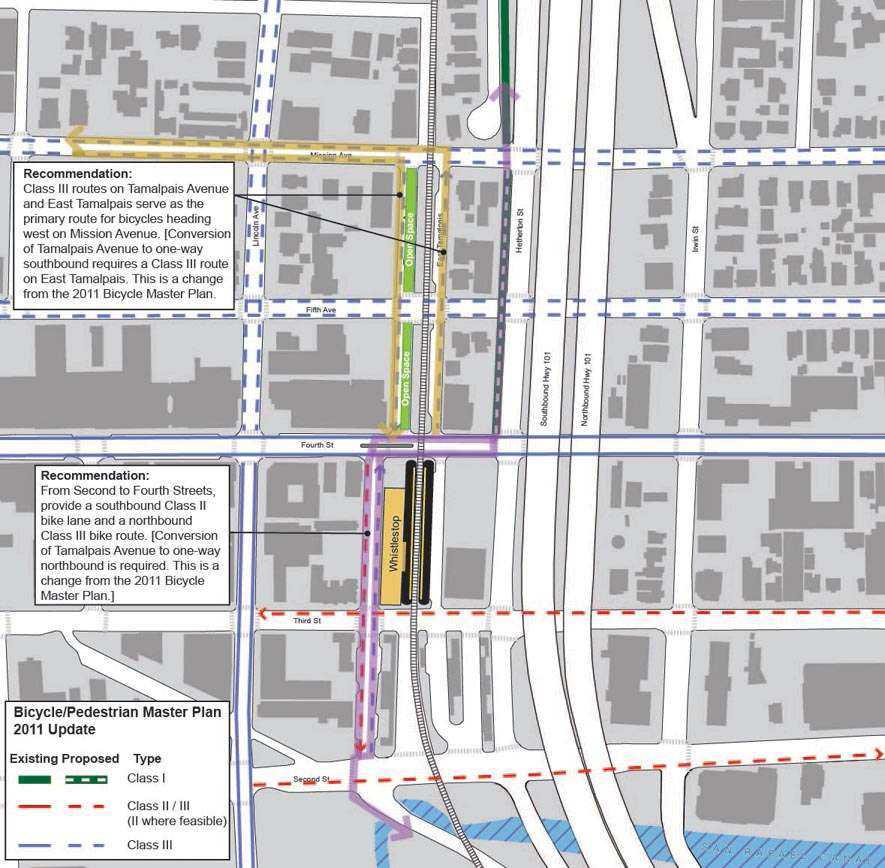
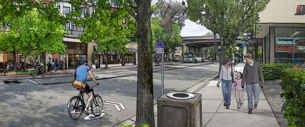
The future downtown station area will need some work. Image from City of San Rafael. Now that the Civic Center Priority Development Area (PDA) has been rescinded, TAM is left with a bucket of PDA-designated cash and even fewer places put it. While Mayor Gary Phillips says downtown San Rafael’s PDA is a logical place to put it, none of the proposed projects in the area are at a stage where they need funding.

Part of the delay is due to San Rafael Public Works (DPW) Director Nader Mansourian’s reported insistence that any road alterations wait until after SMART starts service in 2016. As a result, anything that might disrupt a road’s or intersection’s capacity, or level of service (LOS) will have to wait until the needed capacity is known. That includes bike lanes, traffic lights, crosswalks, bus lanes, etc.

PDA funds must be dedicated to improving the transportation infrastructure within a PDA. While they can target projects outside of a PDA, the project must have a direct positive effect on transportation service within the PDA.

It’s up to the Council and staff to get a slate of needed improvements to the area, from the small to the large. Some possible proposals:

Study which projects in the Downtown Station Area Plan would and would not impact traffic. This is probably the most basic study that would need to be conducted, given that it will be three years before SMART runs and likely another year beyond that before traffic patterns start to emerge. This would give a slate of small projects that could be priced, studied, and built before the train.

Link traffic lights to the rail crossings, done in concert with SMART’s work on the rail crossings themselves. When trains start moving through downtown, they will need to coordinate with traffic flow By linking traffic lights to the crossings, San Rafael could prepare for the trains’ arrival today. The linkage will need to happen on Day One of train operations, and so cannot wait for traffic studies to even begin.

While they’re at it, link traffic lights to bus service. Buses currently crawl through downtown San Rafael, especially northbound trunk service like routes 71 and 101. By allowing traffic lights to sense approaching buses and turn green, a system called signal priority, San Rafael could improve speeds for all bus travelers and improve transit access to and through the downtown station area. While DPW will no doubt want a traffic study to find out precisely how the system should work after SMART, the study will only show how to tweak the system once SMART runs. Benefits could flow long before then.

Fix the Andersen Drive/SMART crossing. One of the principal barriers to getting SMART down to Larkspur is not the station or track but the at-grade intersection of SMART tracks and Andersen Drive. The angle of approach for the train is too shallow for state regulators and so will need to be fixed before the train can proceed south to the ferry terminal. Given that the problem was caused by San Rafael when they extended Andersen, it’s on San Rafael’s head to fix the $6 million problem.

Begin a comparison study of how people move through and shop in downtown. How do shoppers get to downtown? How many people move through downtown? This will give San Rafael planners a snapshot of how SMART and the Station Area Plan changes San Rafael and how to target improvements in the future.

The other pressing projects, even under-freeway parking garages (proposed by the Station Area Plan), will change traffic flow and so won’t pass Mansourian’s muster without a Council mandate. However, staff should draw up a decision tree and timetable for implementation of bike, parking, transit, and other traffic-impacting roadway improvements before SMART begins,

What else would be a good fit for TAM’s PDA-dedicated funds?

Note: I reached out to TAM to determine which of these projects are fundable with PDA money and which are not, but staff have been in a crunch time and haven't been able to answer. I'll post an update when they reply.

The SMART Area, Part 4: Buses, and the Future

Golden Gate Transit

Over the last few days I've been posting my impressions and comments regarding the San Rafael SMART Station Area Plan. It’s such a large, complicated, and potentially game-changing document that it needed more than just a single post. So far, we’ve covered land use and parking, and mobility, and this last post will cover buses the future of the site.

The hero of mobility in the Station Area Plan will not be SMART; it will be Golden Gate Transit. If a Sonoman wants to get to San Anselmo, she will likely go by bus. If a new resident in the Area Plan wants to go to San Francisco, he will go by bus. And if a Corte Maderan needs to get to Santa Rosa, she'll probably take a bus first. Yet, the bus system, as it stands, is widely lamented as inadequate, especially on weekends. How to improve long-range (beyond 2 miles) mobility for residents in and through the area, and how to accommodate the increased service in the study area, should certainly be part of the conversation.

The typical Marin bus route runs every 30 to 60 minutes and is far slower than driving an equivalent distance thanks to a few crazy loops, some too-compact stop densities, lack of signal priority, long stop layovers, and the general restrictions of running on surface streets in traffic. Although there is an effective and complicated transfer system, thanks to a 95% on-time rate, the bus as it currently stands is not a car-replacing transit system.

This bodes ill for transit-oriented development in the Plan Area, not to mention other towns that want to orient their ABAG zoning towards transit – essentially the whole of Marin except for Novato. Without an adequate framework, increased population will lead to more sprawl, meaning more traffic, more pollution, and less open space. We must make the bus work.

There's a debate in the activist community regarding how exactly to do that, but it comes down to a few priorities: improve the absolute quality of the bus service through frequency, improve the relative quality of the bus service by making cars a less attractive choice, and improve the efficiency of rider collection by putting residents and jobs near the stations. In the ideal this means bus rapid transit or just separated lanes, but in Marin's medium-term, such BRT lines on the old rail rights-of-way are probably politically infeasible, and auto mode share would likely remain too great to support the service. Express buses, however, make perfect sense.

Whenever I ride GGT, I hardly see any on-and-off boarding between major stations; people are going from center to center, and ridership is not evenly distributed along the route. GGT should acknowledge this and operate a high-frequency town-to-town express network. GGT's last semi-comprehensive system analysis showed that such express service, combined with developing a system of “green hub” transfer points, would benefit a huge number of riders. If marketed with SMART – a rubber-tire rail – GGT could have a success and draw riders out of the new developments along the SMART corridor.

To boost ridership more generally, GGT should mail every adult within a half-mile radius of the Transit Center a pre-loaded Clipper card with a year-long GGT unlimited ride pass, perhaps in conjunction with the proposed Zipcar membership. San Rafael should allow local businesses to cash-out of some parking requirements by purchasing annual transit passes for their employees. Boulder did something similar to these proposals and saw drive-alone rates drop from 56% to 36%, with the bus taking up the slack. Give people something of value, and they will respond.

The Area Plan makes no mention of improving overall bus capacity or promoting ridership, but it does make some recommendations on how to move the Bettini Transit Center to the SMART site. None of the proposals struck me as particularly attractive, as most of them involve transforming the blocks around the SMART station into rather pedestrian-unfriendly surface stations akin to the Bettini Transit Center today. Other proposals, such as putting bus bays along Heatherton and under the freeway are more attractive from a pedestrian perspective but offer limited capacity.

If San Rafael decides it needs a new parking garage west of 101, the bus terminal should be located to the ground level, giving riders a more weatherproofed facility and allowing the height above the terminal to be used effectively. Bettini's lack of developability is one of the major arguments in the Area Plan for its demolition, so the city should try to lump its desired but ugly infrastructure together. Using the example diagrams from the Area Plan, such a garage would likely provide between 10 and 20 bus bays, depending on the configuration and location of the garage.

The Future

SMART is coming to town, whether people want it or not, and with it will hopefully be a new neighborhood and a new swagger for San Rafael. The city has a chance to come to the forefront of urban policy in the North Bay through innovative (for Marin) land use practices like form-based zoning, parking minimum reform, and true transit-oriented development. Until now, these have simply been words in general plans and housing elements, but San Rafael may actually make it happen. The opportunities here should excite everyone who supports a more walkable, livable, and sustainable Marin.

That's not to say there aren't challenges. Parts of the city staff have a history of choosing car capacity over pedestrian-friendliness, and powerful organizations such as the San Rafael Neighborhood Association could still throw their weight against passage. Both impulses should be resisted by the Council. The opportunities are too great to let this plan slip by.

The Citizens Advisory Committee is meeting on February 2 at 7pm in San Rafael's Community Development Conference Room. The draft plan will go before the City Council some time in March. The Greater Marin will likely be back to its regularly scheduled programming Wednesday.

The SMART Area, Part 3: Mobility

Over the next few days I’ll be posting my impressions and comments regarding the San Rafael SMART Station Area Plan. It’s such a large, complicated, and potentially game-changing document that it needs more than just a single post. Today we tackle the interplay of cars, bikes, and pedestrians. So far, we’ve covered land use and parking, and the last post will cover buses and the future of the site.

The SMART Downtown Station Area is set in a car-centric environment, complete with an elevated freeway and its ramps, pedestrian barriers, dead street frontage, narrow sidewalks, and open lots. There is no traffic calming, little in the way of bicycle infrastructure, and a push to move more and more cars through. This is a transit-oriented development, deliberately focused around means of getting around that don’t include a car. While it does not address needed bus improvements, the Station Area Plan tackles the other issues by building needed infrastructure for walking and cycling. It takes a step back by altering the street network to accommodate more traffic, giving one San Rafael Planning Commissioner “heartburn”, but overall the plan is solid where it chooses to look.

Cars

Highway 101, built as an upgrade to the old Redwood Highway to speed cars to the Golden Gate Bridge and San Francisco, bisects San Rafael. Irving and Heatherton are functionally the frontage roads, one-way strips running north and south respectively, and Second and Third are the on and off ramps, running one-way east and west respectively. This poses immense problems for active living, as a glorified freeway ramp is no place to put a pedestrian or a bicycle.

Car lanes are 12 feet wide, as wide as a freeway lane, but facilitating speed. Timed lights to keep traffic moving and encourages driving at the speed limit but contributes to noise and the perception of danger. There are no traffic-calming measures that I can think of.

For a transit-oriented community this is problematic, but it is understandable given the geography. In most other cities, traffic is funnelled through specific arterials on a wide grid, though if there is a problem on one street, others nearby can soak up the spillover. San Rafael is the primary freeway entrance for Ross Valley, and the whole of downtown is only five blocks wide. Speeding 24,000 cars per day on and off the freeway is a huge challenge for San Rafael, and this is a way to address the problem.

With more density coming to this area, the Area Plan has proposed adding right-turn lanes off Heatherton to Third, increasing the outbound capacity and allowing the roads to keep flowing freely. Unfortunately, the plan proposes doing this while removing a crosswalk along Heatherton to prevent pedestrians from interfering with traffic flow. This is foolish in the extreme, despite the improved bus travel times. Most traffic through this area is pass-through, and there is more than enough capacity on Mission, Fifth, and Fourth to absorb the increase in westbound traffic from these projects. San Rafael needs to focus on calming Second and Third rather than simply pushing more cars through, especially here.

Bicycling

I remember reading a blog comment once to the effect of, “I’ve been car-free in Fairfax for years, but only because I have a bike.” Golden Gate Transit has somewhat thin service for being a car replacement so bicycle ownership is a must for the car-free, and this is almost as true in San Rafael as it is in Fairfax.

Improving the bike-unfriendly areas around San Rafael, especially under the freeway and along Second and Third, are absolutely essential to allow car-free travel around Marin, and the bike lanes included in the plan accomplish at least a bit by facilitating the bicycle connection between Irwin and the multi-use path behind the San Rafael Corporate Center. MCBC has called for a Class I bike lane (or multi-use path, what the rest of the country calls a cycletrack) on West Tamalpais instead of the planned bike lane on East Tamalpais. This is another good idea to be explored, as cycletracks would go a long way to promoting bicycling in all parts of Central Marin, and a good one on West Tamalpais could be a model.

Pedestrians

Walkability is the foundation of a livable neighborhood, a fact acknowledged by the Area Plan. Walking around the Transit Center is a pain, with missing crosswalks, long curb-cuts, and pedestrian barriers at key intersections. Walking under the freeway is unpleasant, especially at night, and the narrow sidewalks put the cars far too close to pedestrians. To solve this, the Area Plan calls for more crosswalks, removal of extraneous curb-cuts, and widening or adding sidewalks throughout the area.

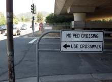
Unfortunately, the most pressing pedestrian problem is handled in an astonishingly ham-fisted sort of way. When SMART arrives, it will be directly across Third from the Transit Center, and there are huge desire lines running between the two facilities. San Rafael, concerned that people would run across Third to catch their bus, wants to erect a pedestrian barrier along most of the length the station's Third Street side, forcing pedestrians to cross at either Heatherton or West Tamalpais, eliminating mid-block crossings from East Tamalpais by commuters desperate to catch their bus. This is the opposite of pedestrian-friendly.

A far better solution would be to initiate a block-long crossing, starting 30 seconds after a train pulls up and lasting 45 seconds, during which time cars would be unable to turn right. As SMART will run only once every half-hour, it would not be too disruptive of bus and car traffic, and Heatherton traffic would still be able to move south during the crossing. To prevent commuter desperation, buses should be instructed to wait a short time after the train arrives, and SMART itself should have real-time departure information displayed in the train for buses at whatever its next stop is.

Overall, the mobility issues addressed by the Station Area Plan are quite large and are handled competently.  Beyond the bizarre pedestrian barrier, removed crosswalk, and new right-turn lane at Third and Heatherton, walkability and bikeability are improved dramatically under this plan.  In our fourth and final installment, we'll tackle buses and the future of the area.

The SMART Area, Part 2: All Those Cars

Over the next few days I’ll be posting my impressions and comments regarding the San Rafael SMART Station Area Plan. It’s such a large, complicated, and potentially game-changing document that it needs more than just a single post. Today we tackle parking. Subsequent posts will examine mobility, and the future of the area. So far, we've covered land use. With all these homes, all this retail, and all these commuters, parking could turn terrible without mitigation.  Although the transit options will be the richest of anywhere in Marin, the rest of Marin will likely remain just as transit-poor as it is today, so the Advisory Committee explored ways to deal with incoming traffic and where to put all the cars.

Overview

As you probably can guess, I’m not one in favor of parking.  You could call me a Shoupite, I suppose: parking has its place, but it should not be required, and where there is a shortage of parking it should be priced until there is no longer a shortage.  For regular drivers, this ensures they will always have a space roughly where they need it, mitigating the need for circling.  For commuters, it means the commuter lot won't fill up by some God-forsaken hour.  For cities, it means new revenue to plow into their neighborhoods and transit systems.

Excluding the 68 spaces that will be removed after SMART rolls into town, there are 144 metered on-street parking spaces (56 removed by SMART) in the Area Plan's study area that hit 50% occupancy at peak usage and 395 off-street, free all-day spaces (12 removed by SMART) that hit 90% occupancy by 11am.  This puts the total demand for off-street parking at for on-street parking at 100 and total demand for all-day parking at 389 spaces.  It's that second one that's awfully tight, and likely why there is overflow.

This poses a parking problem: how can the city accommodate new residences, retail, and offices while providing sufficient parking for new commuters and new shoppers without wrecking the transit-orientation of the area?  The Area Plan believes it can be done by adding more parking, including the area within the downtown shared parking district, and through demand mitigation.

More Parking!

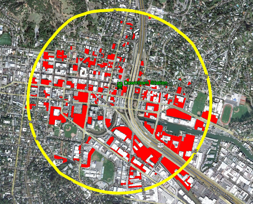
Click to enlarge. Red are parking lots & garages

I'm not entirely convinced there's a need for more parking given the huge number of lots - over 110 by my count - within a half-mile radius of the station.  Much of this is probably due to parking minimums imposed by zoning regulations, but there is still a plethora of parking.  I'd wager that around half the buildable space south of Mission is taken up by parking.  Look especially at the north side of Third Street!  It's just a long line of parking garages.  Little wonder nobody says, "Oo, let's check out that cool place on Third Street!"

As well, with over 90% occupancy of lots that are free, it would seems sensible to me to simply start charging for parking at the various commuter lots, and encourage owners of private parking to open it up to the public, or provide a mechanism for developers to purchase shared parking from those with a surplus, diminishing their own requirements.  As for spillover areas, setting up parking meters with a residential parking permit system should ensure commuters don't park in residential areas, while the city could allow  enterprising residents to rent out their driveways for the day.

Alas, the politics and mechanics of parking are a bit more complicated.  Everybody wants free parking right in front of their destination.  Downtown Tiburon, for example, is often accused of having no parking, but when the city actually looked they found scores of spots, just a little off the beaten path.  As well, with luck, San Rafael's surface parking supply will continue to decrease.  Pricing the parking supply implies that there are competitors to parking, such as transit, cycling and walking, but those are the topic of our next installment.  Decreasing supply implies the same.  The Area Plan takes non-car mobility seriously, but also suggests additional parking, as well as demand mitigation through car sharing.

More Parking, Less Demand

Car sharing is absent in Marin, mostly because our low-density cities and towns can’t support it, but studies have shown it dramatically reduces the need for parking. A single car share vehicle removes 14 cars from the road. The plan suggests allowing developers to forgo some parking if they support on-site car sharing. This is an excellent idea, as the more flexibility a developer has in its parking, the better the city will be. Still, I’d go one step further. As part of the car sharing rollout, San Rafael should give every household within walking distance of the redevelopment area free membership for a year, which would cost a pittance at around $184,000. Marinites are unfamiliar with car sharing, and this could serve to get people out of their cars and onto the sidewalks.

Even with demand minimized, this is still a transit-unfriendly county, and parking will be needed for residents, commuters, and customers.  To keep the burden off the developers, the Area Plan recommends including the area in the downtown shared parking zone, which allows retailers to count spaces in parking garages against their parking minimums, and building another parking garage along Third.

I would hate to see San Rafael add yet another garage onto Third, especially in the middle of an important walking area and so close to other parking garages and lots.  If a garage is really deemed necessary, a better location would be east of the freeway and extending the shared parking zone out to San Rafael High School and Unity Street.  Montecito Shopping Center is overflowing with cars, and they'd probably like having a bit more breathing room.  Besides, the newly tall buildings along Irving will want good access to a garage if they are to be built with less parking than normal.

I'd recommend extending the parking zone to residences as well.  With on-street parking at only 50%, some demand for off-street retail parking could be absorbed by the street, freeing up space in the garages and lots for residents to store their cars.

Parking will be seen as a problem anywhere one goes outside of the mall, but properly managing it will make the place actually attractive rather than just giant parking lots and garages.  Through demand mitigation (carsharing, transit, bicycling), innovative policies to broaden the parking supply, and parking pricing, San Rafael should be able to manage the influx of people to the area.  If parking will truly be a problem, a garage east of the freeway will open up that area for business and support the high-density development planned along Irwin.

Generally, a car is anathema to transit-oriented living, but there's little transit to orient around.  It is difficult to balance the needs of a transit-poor community with the needs of its transit system, but the problem of parking will remain a very real one for the area.  I hope the city will strike that balance - managing demand and providing mobility without encouraging car usage.

The SMART Area, Part 1: Land Use

Over the next few days I’ll be posting my impressions and comments regarding the San Rafael SMART Station Area Plan.  It’s such a large, complicated, and potentially game-changing document that it needs more than just a single post.  Today we tackle land use.  Subsequent posts will examine parking, mobility, and the future of the area.

San Rafael has released its draft downtown SMART Station Area Plan, and I must say that I’m excited.  So many good policies are wrapped into this – reducing parking requirements, form-based zoning, traffic calming, street engagement – that it has the potential to change the face of San Rafael and Marin by showing what can be accomplished with sensible zoning and real walkability.  While not a 180-degree turn in local planning practices, it’s pushing that direction.  If comments from the Planning Commission are any indication, there’s a hunger to go all the way, and that can only mean good things.

If you’re just joining us

San Rafael’s Station Area Plans cover the immediate areas around the upcoming Civic Center (for another post) and downtown SMART stations.  The downtown station will be located at the current site of Whistlestop Wheels and will be the terminus for the system’s Initial Operating Segment (IOS), which will extend north to Guerneville Road in Santa Rosa, roughly 37 miles away.

To prepare for the incoming train, San Rafael convened the Advisory Committee, consisting of representatives from San Rafael; the San Rafael Redevelopment Agency; SMART; the Golden Gate Bridge and Highway District (GGB), which operates GGT; Marin County; Marin Transit; and the Transportation Authority of Marin.  Their mission: to create the first real transit-oriented, mixed-use communities in Marin since the end of the Northwest Pacific Railroad in 1941.

This location is almost antithetical to transit-oriented development, located as it is next to the elevated section of Highway 101 that cuts San Rafael in half.  Second and Third are extremely busy arterials that function as extended freeway ramps, and the area is dominated by parking lots and auto-oriented uses, such as gas stations and body shops.

Almost antithetical, but not quite.  The station neighbors the Bettini Transit Center, which has buses departing frequently to all over the Bay Area and sees thousands of riders per day, and the Fourth Street commercial corridor.  Existing residential neighborhoods have a strong walking component, even under the freeway.  In other words, the neighborhood may be ugly but it is the transit and commercial nexus of the county, and that makes it ripe for redevelopment.

Better zoning

The key to development in this area is fairly basic: make it a place people want to walk around in and stay through safe sidewalks and streets, calm traffic, interesting sights and sounds, and high degrees of connectivity.  This is exactly what the plan advocates.

For land use, the plan recommends increasing height limits along Heatherton to 66 feet, enough for five-story structures, and to raise the limit to 56 feet along Irwin, as well as along Fourth Street to Grand.  Within these zones, the floor-area ratio would be raised to 2.0 and 1.5, respectively, while both areas would see density requirements lifted.  Residential uses would not count towards FAR, while parking minimums would be relaxed, although not eliminated.

I wrote last week about the need for residential development within the core, and the above would aid immensely in this endeavor.  Conceptual plans for the blocks immediately surrounding the station show the possibility of hundreds of new homes.  Given that a household can support 73 square feet of retail, just the example developments would support close to 20,000 square feet of retail.  Given the slack retail market in San Rafael, this will be a major boon to neighboring businesses.  With office development and the centrality of San Rafael to Marin, retail is likely to do extremely well.

The Montecito Neighborhood Association, which represents homeowners along Fifth Street between Irwin and Grand, complained that increasing height along Fourth on their block would overshadow their homes, and I’m inclined to agree.  Really aggressive land-use liberalization could accomplish the same goal of pulling the downtown core across the freeway without increasing heights at all.  Perhaps the city could lift lot coverage maximums, implement a setback maximum, and lift parking requirements while maintaining a two-story height limit.

I hope that the Montecito Neighborhood Association will not come out against larger portions of the plan than just those that would effect their own homes, and so far they have limited their strong opposition to just those recommended changes on the eastern side of the freeway. If they do begin to oppose developments in places that would not effect their homes, San Rafael could have a problem on their hands.

I’m concerned about crowding out the possibility of a second track through town, however.  If the system performs better than anyone expects, it could lead to major problems down the line and severely limit capacity.  I don’t want planning now to put a ceiling on the system if we don’t have to.

In any event, these land use patterns are new and innovative for Marin.  The Planning Commission was strongly in favor of the plan, and some even wished it would go further, instituting parking maximums or abolishing the minimum altogether, but they also felt that San Rafael was not ready for that sort of thing.  This sort of change comes slowly, and the Station Area Plan is the first step.