A measure of Marin's development politics: Regionalism

For decades, Marin has cultivated a reputation as a firmly anti-development county, most recently in vehement protestations against affordable and medium-density housing. This would certainly be a fair assessment if one simply attends or watches government meetings about development policy or read the IJ’s op-ed section. But survey data from One Bay Area shows Marin to be a much more nuanced, and rather divided, place. This is the first in a four-part series on One Bay Area’s (OBA’s) survey and will examine the survey’s shortcomings as well as Marin’s responses on questions of regionalism. Subsequent installments will address Marin’s views on development, quality of life, and transportation.

On the survey

One Bay Area interviewed respondents in all nine Bay Area Counties and released the cross-tabs back in June. While the survey as a whole was informative and solid, there were some questions that were poorly worded and so tested messaging rather than policy.

“Do you support reducing driving to reduce greenhouse gas emissions?” was my least favorite. The Bay Area is strongly liberal and firmly convinced in the reality of global climate change. Of course we want to reduce greenhouse gases. Tying driving to such an obvious outcome doesn’t allow urbanists, who seek to reduce driving for a host of other reasons, to know whether driving reduction can resonate.

Another, “Do you support expanding commuter rail, like BART, to the rest of the Bay Area?”, conflates BART with commuter rail. Rather than focus on our real commuter railroads – Caltrain, SMART, ACE, and Amtrak – the question brings it back to everyone’s favorite transit system. The extremely strong positive response to this question is useless to planners outside BART who need to gauge public opinion on the subject. While it would be informative to SMART planners to see if their advertising campaign is successful in Marin and Sonoma, Napa and Solano are considering their own commuter rail system using light rail technology. Gauging support for such a system would be invaluable.

Regional planning

Marin’s sharp divisions are first seen in a question with overwhelming support in the county: do you support a regional plan? Fully 81.5 percent of Marinites think it’s a good idea, with only 10.7 percent who say it’s not important.  However, Marin has a far higher rate of response for those who answered that it was not at all important than the rest of the region, 8.6 percent in Marin vs. 2.8 percent for the whole region.

We further deviate from the region when discussing priorities. OBA asked whether a regional plan should focus on the economy, the provision of housing and transportation for all, or the reduction of driving and greenhouse gas emissions. Marin sided with the rest of the Bay Area in labeling the economy as the top priority, but was the only county where a plurality of people put greenhouse gas emissions in second place, slightly ahead of housing and transportation.

Answers the question, Which part of the plan is most important to the bay area's future: Improving the local economy, reducing driving and greenhouse gases, or providing access to housing and transportation for everyone?

Asks what about the next most important priority. Notice here, Marin deviates from the rest of the region.

This is at odds with Marinites’ statements on the availability of affordable housing. Fully 67 percent of respondents said they believed the availability was either somewhat poor or poor. Only San Mateo residents were more negative on their affordable housing supply (71.2 percent). Perhaps some Marinites think that the lack of affordable housing isn’t a problem for solving. This sentiment has been expressed often in public testimonies: I scrimped and saved for a house in Novato even though I’d like to live in Tiburon. Why should someone else get taxpayer help when I got none*?

Marin is largely in line with the rest of the region on the subject of whether the region or local governments should plan development. Bay Area-wide, local planning wins out over regional planning by a large margin, 53.3 percent vs. 43.6 percent. Marinites responded 57.7 percent and 38.1 percent, respectively.

sss

The sharp disparity between answers to this question and answers to the first question – whether or not a regional plan was a good idea – implies that Bay Area residents have separated in their minds a regional plan from local planning. Though it would be reasonable to think that they perceive regional plans as coordinating documents and local plans as visceral zoning documents, there’s not enough data to be sure. They could equally have a classic not-in-my-back-yard sentiment: we need affordable housing, just not here. Further studies are needed to clarify just what people think they’re supporting and opposing.

These questions on regionalism begin to explain the unease and rancor in Marin’s development politics. Marinites have a small but determined isolationist streak, and they are a bit more concerned about environmentalism than equity. When issues of affordable housing come up, arguments about social justice and social equity simply won’t hit as hard in San Rafael as they would in San Francisco. And when issues of regional mandates arise, this crosses into dangerous territory for those who are opposed to regional coordination and regional development planning.

But we need to look at how Marinites respond to specific development policies, and we’ll tackle that next time.

*As an aside, all homeowners get taxpayer help in the form of federal and state tax breaks, from the mortgage interest tax deduction to the stabilizing influence of Proposition 13.

Cross-posted to Vibrant Bay Area and Patch.

Odd words from one of San Rafael’s council candidates

The campaign for San Rafael city council is starting to ramp up, with four candidates vying for two open seats. One of them, Randy Warren, has chosen to run on a platform of being a development conservative. Though not necessarily news on its own, his words on why he opposes affordable housing development shows that he doesn’t understand the politics and issues at hand. He still has a chance to catch up, but conservatives need a knowledgeable voice on the council, and right now he still has a way to go. From his announcement press release:

[Randy Warren] believes the city’s Housing Element is gravely flawed.  The proposed affordable housing could end up not going to needy Marin residents but instead to people relocating from other areas around the Bay whose vast numbers could shut out San Rafael’s poor. “We need good quality jobs to support a growing population, and there is no viable plan at present to do that. Wishful thinking is not enough. We need to avoid related increases to unemployment and homelessness, and the risk they present in wage deflation.”

Affordable housing

The purpose of affordable housing is to do what he says it will: help those who work in Marin but can't afford to live here find a home. I'm not a fan of the methods used by the state to promote affordable housing, namely the regional housing needs allocation (RHNA) process, but my problem with it has to do with its viability, not that it will do what it's advertised to do. Warren implies there will be a bait-and-switch, where we build housing for Marinites only to find them filled by folks from elsewhere.

There is a huge amount of demand to live in Marin. This is seen not only in recent price spikes in housing and rent costs, but in our massive in-commuting population. Marin gets 45,000 in-commuters every day, mostly from Contra Costa and Sonoma but also from San Francisco and Alameda. Studies have shown that they typically take lower-paying jobs, either as service workers (housekeepers, shop clerks) or other professions (teachers, low-level office workers). They simply can't afford a home in the county, especially if they're trying to move here now, and so they in-commute.

Affordable housing is designed to reduce that amount of in-commuting, decreasing their cost of commuting and reducing the pressure on our roadways, not just to support Marin's existing low-income residents who presumably already have homes.

Jobs

Even stranger, however, is that Warren, while insisting we don't build affordable housing for non-Marinites, expresses concern that we aren't creating enough jobs for a "growing population." If we don't, he warns, we'll get increasing unemployment, homelessness, and wage deflation. I'm curious where this population growth would come from if not from beyond Marin, and why they'd come here if they didn't have a job. Perhaps he's talking about Marin's children, but surely he understands that Marin's demographics are such that it won't grow without immigration. But let's set this statement aside for a moment and focus on the jobs themselves.

First of all, Marin already has more jobs than it has workers. While 45,000 people commute to Marin every day, only 42,000 commute from Marin. In San Rafael itself, which is where Warren should concern himself, nearly 70 percent of jobs are held by out-of-towners. Marin, and especially his city, have more than enough jobs to support their own.

The problem, at least in the county at large, is that a great many of these jobs are not ones that many Marinites want or can afford to take. If we wanted to grow our jobs base, we would need to boost the number of high-paying professional jobs. That would mean drawing on the economic strength of San Francisco, developing places that are conducive to start-ups and innovation. Better transit connections for the predominantly car-free San Franciscans, as well as small housing units to keep Marin's young singles in-county, are needed to attract those high-paying businesses to San Rafael.

Alas, Warren, according to the IJ, wants to remove the Downtown San Rafael Planned Development Area (PDA), the place that would be most conducive to creating such an urban job center. By removing the PDA he would put at risk the targeted transportation investments the area desperately needs: a new bus terminal, better bike lanes, better connectivity from the rest of Marin, San Francisco, and the East Bay. At the same stroke, he would make the area less attractive to new businesses that may want to come.

But Marin doesn't have an unemployment problem. In fact, it has one of the strongest job markets in the state. Homelessness, while a problem, is not due to a lack of jobs. It's due to a complicated web of issues ranging from a lack of mental health services to the inherent instability of homelessness itself. A strong progressive shift in the zoning code in larger cities to allow more single-room occupancy hotels (SROs) as well as for-profit, sanitary bunking situations (think something like a more permanent hostel) would go a long way to fighting the "homeless" aspect of homelessness, while better investments in city services would help alleviate the underlying instability and poverty.

As for his last statement, that a lack of jobs in a single city of 56,000 would result in wage deflation, it is such a leap that it is beyond me. San Rafael is part of a much broader region and county, and its job market is deeply integrated with theirs. As we already established, it is so integrated that barely more than 30 percent of its jobs are held by locals. It would take forces far beyond the scope of the San Rafael City Council to depress the city's wages.

Not a promising start

These are odd and troubling statements from a serious candidate for city council. Development conservatives deserve a strong and articulate voice to represent their interests, someone who knows how cities operate in the region's context. Warren misunderstands the purpose of affordable housing, does not grasp the connection between land use and transportation, and does not understand San Rafael's job market.

Though I disagree with the development conservative position on a number of fronts, a knowledgeable councilmember could provide a needed skeptical eye to staff reports. He or she would be a valuable force and help shift the power of San Rafael from its departments to the council. I'm concerned, however, that Warren would be less of a check and more of a contrarian and populist, asking questions for their own sake and grandstanding instead of leading. At worst, he would isolate himself and bring discord to what is currently a collegial and effective body. I'd hate to see the problems of Sausalito replicated in Marin's largest city.

But the race is still young, and perhaps Warren is just getting his campaign legs. Over time, I'm sure he'll release more statements and say other things that will help refine our understanding of his views. But this is not a promising start.

When transit affordability and convenience are at odds

Last week, an IJ editorial on pricing ferry parking took a cautious note. “The bridge board needs to maintain a focus on keeping the ferry affordable to all and a convenient and dependable way to get to and from work.” The IJ is concerned that charging for parking will make the ferry unaffordable. But the aim shouldn’t be more affordability; it should be for efficiency. And, the best way to manage a scarce resource efficiently, including ferry parking, is to put a price on it. It’s a basic principal of economics. Supply can meet demand only when the resource has the right price. Higher prices discourage consumers from using the resource and encourage producers from making more of it. When it comes to a relatively fixed resource (inelastic supply), like parking, the price just regulates demand.

In the real world, a price forces someone to consider whether that resource is actually worth paying for. Is a parking space worth $2? Those who answer no will either get to the ferry another way or take another mode of transportation to the City. This leaves room for others who are willing to pay but who couldn’t find a space before.

Here’s the neat thing. By putting a price on parking, suddenly accessing the resource, while more expensive, is actually more convenient and dependable. Today we have a shortage of spaces, and someone who doesn’t show up by 7:30am is probably not going to get a parking space. If the price is such that, say, 5 percent of parking spaces are free each day, that means there will always be parking available, even in the middle of the day.

The IJ should concern itself not with how cheap we can make a ferry trip but how efficiently we can manage the ferry’s infrastructure. Thankfully, GGT is concerned about this. So rather than spend tens of millions to boost the parking supply, GGT wants to regulate it with a fee. People can still get to the ferry for free if they want to, with a shuttle, foot, or bike, but there is room to spare there. If GGT wants to operate with efficiency, this is where people need to go.

Demographically-mixed housing plans still draw opposition

Monday's post on sister blog Vibrant Bay Area addressed the politics of affordable housing, especially in Marin. Author Dave Alden's thesis, in short, was that the wealthy are happy to welcome those of lower incomes into their neighborhood as long as they only work there. To actually allow them to live there raises the heckles of the wealthy whether it's in Marin, or Portland, or LA. Pundits and activists in Marin have struggled to come up with reasons why that aren't inherently offensive. Development liberals often blame their opponents of racism or classism. While there may be some strains of this in the debate (a recent comment about how Strawberry "already looks like the UN" implied, perhaps inadvertently, that more affordable housing would mean more minorities, for example), prejudice is too simplistic to be an adequate explanation for Marin's opposition. Development conservatives claim they are the vanguard against rapacious developers and out-of-touch bureaucrats, who will end up destroying Marin's small-town character in pursuit of profit, social experimentation, or political power. This, too, is overly simplistic, again painting opponents as devils, though with a different set of horns.

Marin's debate has suffered from this mutual vilification. Our shields and swords are out when we should be learning and listening. It's tough, even for me, to swallow my pride and listen to those who have called me a utopian fascist (right) or naive (left). But I need to listen if I'm going to fulfill the role I set out to do in this blog: to educate people on best practices found elsewhere and advocate for their implementation. There is always common ground, provided I am more interested in finding it than kicking my opponent in the teeth.

Alden's point, in this light, is that wealthy areas don't know how to have this debate and never have. He's worth reading.

Bay Area Bike Share is for the suburbanite, too

Annual memberships for Bay Area Bike Share (which will probably end up being known as BABS) went on sale this week for $88. The bike-sharing service, which will launch in San Francisco and along the Peninsula this year, could dramatically change how the western Bay Area moves around. For those in the North and East Bay commuting to San Francisco, you might want to take notice. Even without stations of your own, a membership could still be worth the price. During rush hour in downtown San Francisco, getting around by transit can be… difficult. BART and Muni Metro run well but trains are beyond crowded. Buses and cars get stuck in gridlock, and so biking is really the only way to move through the City with any speed. But getting your bike to San Francisco can be exceptionally difficult, too. That’s where BABS comes in.

BABS will let a commuter move easily from bus or ferry to someplace far from their stop. If you need to get to anywhere in downtown, you won’t be by what’s within walking distance of the Transbay Terminal or the Ferry Building. Ferry commuters and East Bay bus riders could benefit immensely from membership, as their transit choice doesn’t cover much of the City’s core.

A potential weakness, of course, will be that the central commuter hubs in San Francisco (namely the Ferry Building, the Transbay Terminal, and 4th & King Caltrain) will experience demand that outstrips the available BABS bikes and docks. Encouraging counter-commuters to use those hubs to leave the city would help balance the load. BABS should advertise heavily on the north side of ferry stations and look at expanding into ferry origins, like Vallejo, Jack London Square, and Central Marin, to encourage in-commuter membership and counter-commuting.

During your term of membership, you get unlimited free 30-minute rides. The next half-hour will cost you $4, and each subsequent 30 minutes will cost you $7. The point is to get you to dock your bike at a BABS station, not keep it all day. You’d be surprised how far you can get in 30 minutes.

An annual membership will set you back $88 (which will eventually pay for itself if you usually transfer to Muni), but if you just want to try, a 3-day membership is $22 and a one-day membership is $9. You can sign up today. Are you going to take the plunge?

Zipcar will be a boon to San Rafael

Zipcars Zipcar has made it to San Rafael, and that is absolutely wonderful news. It will make car-free living easier and opens up opportunities for the City of San Rafael to save money on its municipal fleet. It’s only three cars so far, but for downtown residents that may be all they need.

Zipcar works on a subscription model. Light users pay an annual membership fee as well as rental cost per hour or per day, which are different depending on which car the user rents. Heavier users pay a monthly fee, no annual fee, and have lower hourly fees. Organizations, including universities, can also sign up, which is especially useful for businesses whose employees tend to travel a lot during a workday, though with only three cars available it wouldn’t be the most reliable service just yet.

For this, Zipcar subscribers don’t just get access to a car. It covers the cost of gas, insurance, maintenance, replacement, and the home parking space. So while the up-front costs seem steep at first, the end result is that users often end up paying less than they would by relying on their own car.

Yet despite that, these up-front costs do change the behavior of members (PDF). Zipcar subscribers have a barrier, albeit a short one, to using a car. Rather than simply hopping in the family sedan to drive to get a haircut, Zipcar members need to reserve their car for a selected amount of time, and they immediately see how much that trip will cost them. Maybe the trip would be worth it by car, but it turns driving into a conscious choice rather than a default alternative. As a result, use of modes other than driving increases among members.

For planners and developers, this means drivers don’t need as much car space. Not only will they not be on the road as much, but they also won’t need to park in as many places and they won’t need their own personal parking spot. Zipcar’s spot, shared with others, will be enough. So a new housing development with a lot of Zipcar members won’t need as much parking, and a city with a lot of members won’t need its roads to be quite as wide.

This behavioral shift isn’t unique to Zipcar, of course. Car-sharing services from Avis and Budget, as well as standalone services like Car2Go, are just as likely to change how people drive.

If San Rafael wants Zipcar to expand, the city should allow developers to cut parking requirements from their projects if they host car-sharing cars or subsidize membership for their residents. This would build a client base for Zipcar or its competitors while also reducing the number of cars in our parking lots and on our roads.

In short, Zipcar’s entrance into the San Rafael market is a Very Good Thing. Here’s hoping they’re here to stay.

A fare hike, a toll freeze

Five years ago, the Golden Gate Bridge, Highway, and Transportation District (GGBHTD) considered varying bridge tolls based on demand, with higher prices during peak demand times. The concept, called congestion management or congestion pricing, didn't go anywhere. Then-San Rafael mayor Al Boro torpedoed it, labeling the proposal an unfair "Marin commuter tax." San Francisco was outraged, but at least they got a pioneering new parking system that varies the price of on-street parking by demand instead. Meanwhile, GGT's often-high fares have gone up by 5% every year on July 1. If congestion management is a "Marin commuter tax", surely annual fare hikes well above inflation are the same thing. While the purpose is to try to keep fares in line with costs, the hikes aren’t targeted well enough to either manage congestion or improve the agency’s financial standing.

Better than blanket hikes would be targeted hikes to ferry fares and bridge tolls paired with bus service improvements. GGBHTD should use its monopoly power to maximize the infrastructure it has at its disposal.

Ferry ridership has proven to be extremely robust and can likely absorb the hikes, increasing its farebox recovery. For bridge tolls, the stretch of Highway 101 between Sir Francis Drake and Tiburon boulevards is about 800 cars over-capacity in the evenings, or roughly 2/5ths of a freeway lane. Adjusting tolls and bus service to shift some of demand to buses would open up the northbound direction. Trunk line bus service would be more reliable and less expensive to operate, and drivers would save 20 minutes of time every night.

Yet with a blanket 5% hike on regional and commute buses, GGBHTD is actually exacerbating its bus ridership problems. It shifts demand from a mode with excess capacity to one that is already over-capacity. This is not smart management but political management, and the outcome is worse service and worse traffic.

The kids want Marin but not the car

Star-spangled banner The media was abuzz last month with news that the country is driving less than we have since 1996 and a report find that this trend will likely continue for at least another 30 years. Simultaneously, reports of housing preference finds that Americans increasingly want walkable, bike-friendly places to live. Both trends are most pronounced in Millennial and Boomers, the two largest cohorts working their way through our demography.

While most of the country's suburbs grapple with some seriously car-centered places that are rapidly losing value, Marin is a special case. Our network of walkable town centers is precisely what people are looking for. They provide independence the sprawl of other places can't. Even our arterial roads (mostly) have sidewalks, an amenity other cities dream of.

But we do need reform to capture this market, or Marin risks losing its children.

The push against driving

For the last 8 years, travel patterns have been shifting dramatically in the United States.

Since 2005, vehicle miles traveled - how many miles Americans drive - has been in decline. According to USPIRG, Americans now drive about as much per capita as we did in 1995 and as much overall as we did in 2004, while Californians have returned to 2005 and 1995 levels, respectively. Nationally, 16 to 34-year-olds drove a whopping 23 percent less in 2009 than they did in 2001.

Taking its place have been bicycling and transit, the use of which has climbed to record levels. Bicycling rates are tough to measure, thanks to very low starting numbers, but at least in San Francisco it grew 71 percent from 2006-2011. Easier to measure is the growth in transit usage, which is up 12 percent since 2002 and is now at a level similar to the 1950s. Young people, meanwhile, are taking transit for 40 percent more miles than their age group was 8 years ago.

USPIRG thinks this trend will continue, as the number of teenagers and young adults with drivers' licenses has declined significantly - to levels not seen since the 1970s - and shows no sign of abating. Consumer surveys show little interest in driving or cars among the young, with most viewing car ownership as a burden instead of a freedom. Instead, mobile devices have become symbols of freedom and status. Even AAA admits that any operation of these devices in a car, even by voice, is incredibly unsafe.

This shift in preference marks a significant difference of opinion from their parents' generation, which saw cars as signs of adulthood, freedom, and status. However, even those Boomers are starting to drive less. As they retire, they'll be able to cut the daily commute. And, over the next 20 years, more and more will age out of driving. This will further depress our VMT.

The push for walkability

Though many have gone through an urban phase before decamping to the suburbs, no modern generation has so embraced the city as the Millennials.

Across the country, this preference has shown up in price spikes around downtown cores, some of which have been in decline for decades. And it's not just the big name cities, either. While Detroit, Washington, and New York get headlines, places like Kansas City, MO, and Charlotte, NC, are seeing their downtowns' fortunes revive.

Driving the demand for city living is demand for high access by foot and bike to jobs, shops, and services. Though some love the bustle of the city, others just want the pleasant walk to the store, whether in a city or a suburb. Marin's town cores offer the balance of city and suburb that is all too rare outside New England.

Yet the continued focus on drivability over biking, walking, and transit puts a damper on Marin's ability to capitalize on this natural advantage. Rather than expand our town centers, we allow them to be islands of walkable living in a sea of pedestrian-unfriendly arterial roads. We value them, true, but we keep them in a box.

Instead of just preserving them, we ought to allow them to expand. Why should downtown Mill Valley be contained north of Sunnyside? Or downtown San Anselmo remain a 6-block strip along San Anselmo Avenue? Only Fairfax has expanded its downtown zone, replacing all its parking-heavy Highway Commercial zone with Downtown zoning.

Yet even within town cores, housing for singles - one bedrooms and studios - are strongly discouraged by a potent mix of parking minimums and density limits. Between town cores, the bicycling infrastructure needed for the most utilitarian trips - with cargo bikes or small children - is practically nonexistent.

Does this mean the end of the single-family detached home in Marin? Hardly. Though the more strident opponents of change in Marin claim any change means wholesale demolition of car-centric neighborhoods in Marinwood and Novato, there is still absolutely a place for them in the housing mix. Rather, what Marin needs is more diversity of transportation and housing options, not less, as has lately been the case.

If Marin wants to keep the residents that made the county a counter-culture mecca while attracting a new generation to a quieter alternative to San Francisco and Oakland, it will need to address this shifting reality. Eventually the Boomers will be unable to or unsafe to drive (asking them to purchase a self-driving car is simply outsourcing the problem), and the Millennials that should take their place will want better bike lanes and better transit options.

If we don't adapt, Marin risks becoming an exclusive enclave for the rich and retired, hardly a fitting end to the hippies who put Marin on the map.

GGT offers a thin lifeline in the BART strike

BART is on strike. I’ll spare you the gory details of why, as they’re covered much more extensively in other news media. However, now’s a good time to refresh minds about bus service through Marin. Though not ideal, it could be better than nothing for those who can get to Richmond or Del Norte BART stations. GGT routes 40 and 42 head to San Rafael, where a commuter can transfer to San Francisco-bound 27, 44, 70, 80, and 101. If you don’t want to wait, or if you think you’ll get lost in the crowd, you can head down the freeway on routes 17, 36, or 71 to one of the other commuter lines. As usual, pack the 101 service pocket guide.

The thing you probably won’t want to do is head to the Larkspur ferry. Parking is cramped as it is, and direct bus access is minimal. If you insist on a ferry, get on almost any bus heading south (17, 27, 36, 70, 71, 80) and hop off at the next stop. You have a ¾ mile walk from there. That, or drive to the ferry before 7am.

GGT has a much more extensive listing of how to get to SF. The fastest way may be to take a commuter bus from north of San Rafael so as to avoid the general traffic lanes through as much of Marin as you can. However, south of Marin City, the HOV lanes end and you'll get stuck in traffic. At least you can sleep through the stop-and-go.

Good luck out there. It's brutal.


Personalized mapping

Transit maps in Marin are, well, not very good. Especially for the uninitiated, they can be confusing spaghetti. About a year ago, I was contacted by a young man in Novato who had his drivers' license suspended for some reason and wanted to know how to get around to his destinations. He went to school in College of Marin, worked in Petaluma, and hung out with his friends in the East Bay. How was he supposed to get out of Novato without a car?

After an abortive attempt at a Novato spider map, I realized all I needed were the various connections between the destinations so he could know exactly how he could get from A to B without all the mess of geography. The map below is the result.

GGT Novato-2

It's simple, so it doesn't include things like frequency or span of service. Instead, I wanted to show how to get from place to place, major stops, and where those routes went after transfer points and destinations, without all the fuss of a more detailed map. Were I to make this again, I would probably place 49/49K to the west of the 101 corridor north of Ignacio and east of it to the south to reflect actual geography, but as it stands I think there's enough hints for the user to see where the bus goes.

I've never followed up with him to see how it went, though he seemed pretty excited to see it. Perhaps it will be of some use to you as well, as it's now up in the Map Room.

GGBHTD responds to my series on ferry parking

A couple of months ago, I wrote a four-part series on Larkspur Landing's parking and access problems. I discussed the possibility of a parking district, a shuttle, transit-oriented development, as well as the constraints on the terminal's passenger capacity. When the Golden Gate Bridge, Highway, and Transportation District (GGBHTD) called for comment on access to the ferry terminal, I summarized the first two into a two-page letter, complete with cost/benefit table, and sent it to the Board and staff. Last week, I got a response from GGBHTD responding to some of my proposals. Here's what they sent me:

Dear Mr. Edmonson [sic]:

The Golden Gate Bridge, Highway and Transportation District (District) is in receipt of your letter, dated April 23, 2013, addressed to the members of the Board of Directors, expressing your concerns relative to the "Strategic Vision for the Golden Gate Ferry Larkspur Service (Strategic Vision." Staff has researched the issues you raise din your letter regarding your assessment of unused parking in the vicinity of the larkspur Ferry Terminal, and your interest in a shuttle from San Rafael Transit Center (SRTC) to the ferry terminal.

With regard to parking in the vicinity of the Larkspur Ferry Terminal, the Larkspur Station Area Plan did identify a large amount of surface parking at the various parcels within a radius. However, the examination of that parking was looking in the context of increasing the density of the existing surface spaces. These surface parking spaces were identified for future opportunities to provide for mixed use development and structured parking opportunities. Presently, these parking spaces are needed by the various commercial tenants on these properties. Staff has communicated with various property managers in the area who indicated that their office occupancies are in the low ninety percent range and rising. Although the District did lease some surface spaces many years ago, property managers indicated that they could not consider that possibility at this time, due to their rising demand.

With regard to the shuttle form the SRTC to the Larkspur Ferry Terminal, limited parking in the vicinity of the SRTC would be a barrier to its use. The District operated a midday ferry shuttle from the SRTC to and from the Larkspur Ferry Terminal during 2007 as a demonstration project that, unfortunately, was not successful. Among the reasons cited for passengers not using this service were lack of parking in the vicinity of the SRTC and the inconvenience of using other Golden Gate Transit routes to access this shuttle, due to the need to transfer twice to reach the ferry.

As you may be aware, the Board of directors (Board) approved adoption of the Strategic Vision at its meeting of May 10, 2013, with the understanding that staff would bring individual projects forward to determine cost, feasibility and implementation on a case-by-case basis. The Strategic Vision includes both near-term strategies to address current increasing demand, as well as longer-term strategies to allow for the capacity for ridership to continue to increase. Both parking considerations and a possible demonstration project to test the reinstatement of a ferry shuttle route in the Sir Francis Drake Boulevard corridor will be brought back to the Board for review and possible action this summer.

Thank you for taking the time to express your concerns and for your interest in the District’s Strategic Vision.

Sincerely,

James C. Eddie President, Board of Directors

I'm glad they took the time to talk with local parking owners, as that would be the easiest way to address the parking crunch, but it's a disappointment that they were asked whether they'd be willing to lease spaces to the District instead of participate in a parking district. A parking district gives owners control over how many spaces to have available on a daily basis, whereas a lease locks up spaces for years. Though the SMART parking survey showed there would be enough space even with 100 percent occupancy, it's understandable that parking owners wouldn't want to risk their parking spaces with a lease.

The 2007 shuttle from SRTC failed not because of little parking, though that would be a problem for some, but because it competed with free parking at the ferry terminal. But no matter. Marin Transit will service the Ferry Terminal via SRTC come next year, and the ferry shuttle along Sir Francis Drake will be accompanied by paid parking at Larkspur Ferry Terminal.

Overall, I'm happy the staff took the time to look into the issues I raised, or at the very least to draft a coherent response. It means they are taking public input seriously, and it validates citizen technical activism. That's a pattern other agencies, especially SMART, should take note of.


Quiet and Safe San Rafael gets it wrong on density

A few weeks ago, Quiet and Safe San Rafael (QSSR) published the claim that 79 units per acre, zoned for potentially proposed for in Terra Linda*, is more dense than Manhattan or Hong Kong. Though they are technically correct, QSSR wildly misinterprets the concept, the data, and ignores the density already in our midst.

Density limits

A density limit in Marin restricts how many units can fit on the parcel as measured in acres. 2 units on a quarter-acre parcel works out to 8 units per acre (2 divided by 0.25 equals 8). This doesn't include the street, parks, commercial development, or anything else beyond the building's parcel.

I don't know how Hong Kong does their density limits, but Manhattan doesn't usually have per-unit density limits. Instead, New York limits how much floor area a building can have (a measure called floor-area ratio, or FAR, if you're wondering). Again, this is based on the parcel, not the supporting infrastructure or all the other buildings.

The danger with measuring densities at a municipal level, as QSSR has done with Manhattan and Hong Kong, is that it does include all the rest of the city. It's like measuring the size of a house and calling it all a bedroom. It is disingenuous to compare that to the parcel-based densities used by San Rafael.

So while it's true that Manhattan averages 58 units per acre, higher than Terra Linda's allowed 79, that includes Central Park, Times Square, the avenues and streets, the docks, ferry terminals, office buildings, plazas, schools, police stations, City Hall, the UN, the New York Stock Exchange, and all the other things that aren't housing on that island.

Rafael Commons

That's ridiculous. Using San Rafael's measuring system, a 20-story tower in Manhattan would average to 800 units per acre, far and away higher than Terra Linda's 79. There's a three-story senior home, San Rafael Commons, that hits 90 units per acre. Is it "more dense than Manhattan"? Not in any meaningful sense.

This exposes the danger of using density as a proxy for character, as it doesn't measure anything about that. Character comes from a building's form: how tall it is, how far back it's set from other buildings or the street, etc. A single-family home can fit a second unit in the back, which doubles the parcel's density. A three-story building could be filled with two-bedroom apartments and be low density, or be filled with studio apartments and be high density. It wouldn't change the building's visual impact.

Whether QSSR tried to be deliberately misleading or not, it is clear they are trying to stir up fear of tower blocks along 101. There are legitimate things to worry about in Plan Bay Area and legitimate things to critique. It's truly unfortunate this activist group has chosen to focus on the ridiculous instead.

*Update and Correction: The intro misstated the current zoning and planned zoning and density around the Civic Center SMART station. Current zoning tops out at 43 units per acre, depending on where one looks. San Rafael's Station Area Plan calls for densities "above 44 units per acre", while the proposed Transit Town Center PDA calls for zoning to accommodate 20-75 units per acre. QSSR's number comes from the average of all PDAs in the Bay Area, which is not applicable to any individual PDA like the Civic Center area in Terra Linda.

Report: the FRA makes trains less safe, more expensive

A new report out by the Competitive Enterprise Institute (and I suspect you’ll recognize half the byline), says the FRA’s safety regulations, enforced in the name of safety, perversely make us less safe. Rather than use the best practices of Europe or encourage train manufacturers to innovate, the FRA’s rules prescribe antiquated crash management technology from the 1910s. Dangerous and more expensive trains are the result. To find out why, you’ll need to read the report for yourself. It’s an easy read, just six pages, and it details how SMART, in the West, and Acela, in the East, have been dramatically affected by the FRA’s regulations, though they aren’t the only victims. You can see the stark difference between the two regimes in a crash test video that went into the FRA’s report on its own safety measures. The top train is FRA-compliant, while the bottom is compliant with European regulations from the International Union of Railways (UIC):

[youtube http://www.youtube.com/watch?v=NUpUJrk4QBE?rel=0]

The top train experiences something called an “override”, which you’ll find mentioned in the report. It’s what FRA-compliant trains too-often do in a crash. And, on the bottom train, you can even watch how, for a split second during the crash, the oncoming train pauses to absorb the crash energy. That's UIC crash safety in action.

Something I realized after the report had been written, too, was that the FRA's rules hurt domestic train manufacturers. FRA-compliant trains are illegal overseas, as they don’t meet UIC standards, just as European trains don’t meet American safety standards. This forces domestic manufacturers to choose between serving the tiny US market or the much larger global market.

Though bashing the FRA is a favored pastime among more technically-minded bloggers, desperately needed regulatory reform seems to have gained little traction where it matters most. Here’s hoping CEI’s white paper can change that.

Loving the city we can't stand

Sometimes, I wonder at my fellow urbanists, especially those who can live wherever they like. They have chosen, for whatever reason, to live in certain places and write sometimes deeply critical things about those places. It seems incongruous. Why would someone choose to live somewhere frustrating? Why live under bad leaders with bad judgment? Or, to paraphrase something often heard from an opponent, if we dislike our home so much, why don't we leave it? Anthony Cardenas, who was arrested for painting a crosswalk in Vallejo last Thursday, reminded me that often it's not a rational decision but a fundamentally, gloriously irrational decision. He and urbanists in other deeply dysfunctional cities love their places. And when you love a place, just as when you love a person, there's nothing you won't do to fight for their well-being.

G. K. Chesterton, a wonderful British author from the turn of the 20th Century, believed this love was vital to the health of a city. In Heretics, a collection of essays skewering the thinkers and authors of his day, Chesterton devotes a chapter to Rudyard Kipling. Kipling's practical, rational love of England, he writes, is no love at all. It is appreciation. Kipling flirts with England, just as he flirts with China and Venice, but he has never married her.

In Orthodoxy, the follow-up to Heretics, Chesterton expands the value of loving a place and a city to which you belong.

My acceptance of the universe is not optimism, it is more like patriotism. It is a matter of primary loyalty. The world is not a lodging-house at Brighton, which we are to leave because it is miserable. It is the fortress of our family, with the flag flying on the turret, and the more miserable it is the less we should leave it. The point is not that this world is too sad to love or too glad not to love; the point is that when you do love a thing, its gladness is a reason for loving it, and its sadness a reason for loving it more. All optimistic thoughts about England and all pessimistic thoughts about her are alike reasons for the English patriot. Similarly, optimism and pessimism are alike arguments for the cosmic patriot.

Let us suppose we are confronted with a desperate thing—say Pimlico. [In Chesterton's day, the London neighborhood of Pimlico had fallen far from the glory of its construction and was in a state much like many of America's urban cores.] If we think what is really best for Pimlico we shall find the thread of thought leads to the throne or the mystic and the arbitrary. It is not enough for a man to disapprove of Pimlico: in that case he will merely cut his throat or move to Chelsea. Nor, certainly, is it enough for a man to approve of Pimlico: for then it will remain Pimlico, which would be awful. The only way out of it seems to be for somebody to love Pimlico: to love it with a transcendental tie and without any earthly reason. If there arose a man who loved Pimlico, then Pimlico would rise into ivory towers and golden pinnacles; Pimlico would attire herself as a woman does when she is loved. For decoration is not given to hide horrible things: but to decorate things already adorable. A mother does not give her child a blue bow because he is so ugly without it. A lover does not give a girl a necklace to hide her neck. If men loved Pimlico as mothers love children, arbitrarily, because it is THEIRS, Pimlico in a year or two might be fairer than Florence. Some readers will say that this is a mere fantasy. I answer that this is the actual history of mankind. This, as a fact, is how cities did grow great. Go back to the darkest roots of civilization and you will find them knotted round some sacred stone or encircling some sacred well. People first paid honour to a spot and afterwards gained glory for it. Men did not love Rome because she was great. She was great because they had loved her.

The activist in the place where they are constantly stymied, where the newspaper is nothing but bad news for their cause, remains because of love. The activist works and cries and paints crosswalks because she love her place. We'd all move to London or Rome if we just wanted a more comfortable place to live. Even I, in Washington, cannot help but love that marvelous county. Marin is in my bones, as much a part of me as my family. How could I not write?

Chesterton goes on to write about the nature of conflict over a place. There are the jingoists, who say everything's fine in order to save their city's honor; there are the pessimists, who love to criticize because they get a thrill out of it; and there are the rational optimists, who love a place for a specific reason, never letting go of that reason despite all facts.

And there are those opponents of ours who are no less irrationally in love with the place. We should not fight with any less conviction, but we should give respect. We are lovers of the same place; there ought to be a kinship that colors our fights.

Anthony Cardenas, I'm sure, is disheartened and angry at Vallejo and Caltrans for how he's been treated. But he will probably stay because he loves his neighborhood and city. Perhaps, one day, West Vallejo will rise into ivory towers and golden pinnacles because of people like him. Maybe, too, will Cleveland, and Detroit, and Stockton, and Fresno, and...


Marin's towns are destinations

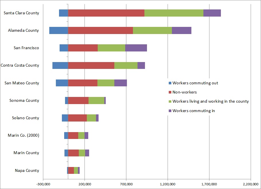
Population is a statistic everyone knows about a town. It's an important stat, as it tells us how many residents there are, roughly how many taxpayers there are, how many voters, etc. However, especially for large cities, it's extremely important to know how many people are in the city during the day. Commuters swell San Francisco's daytime population to over 950,000, a fifth more than actually live there. Daytime Population-County Chart

For smaller cities and towns, the daytime population numbers tell us how mobile people are and how much of a destination a place is. If there are a lot of workers coming in, it's an employment center. If there are a lot going out, it's a bedroom community. And if there are both a lot coming in and a lot going out, there is a mismatch between a city's jobs and its people.

The US Census Bureau ran the numbers on cities and places with a population of 2,500 or more, and the Atlantic Cities covered what the data means for big cities and regions. I'm curious about what it means for Marin.

Daytime Population-City Chart

Marin has been undergoing a transformation for the last 30 years, moving away from being a bedroom community for San Francisco and more toward being a jobs destination in its own right. Though the shift has been slow, Marin now has more jobs than workers, owing in part to a decline in the workforce and in part to an increase in jobs. The number of people commuting in has grown 3 percent; the number of people commuting out has shrunk 12 percent; and daily change in population has swung from -1.6 percent to +1.2 percent.

Data from other sources says most of Marin's 45,000 in-commuting workers live in Sonoma and Contra Costa, but we get some from San Francisco and Alameda as well. All told, these folks hold 37 percent of Marin's jobs.

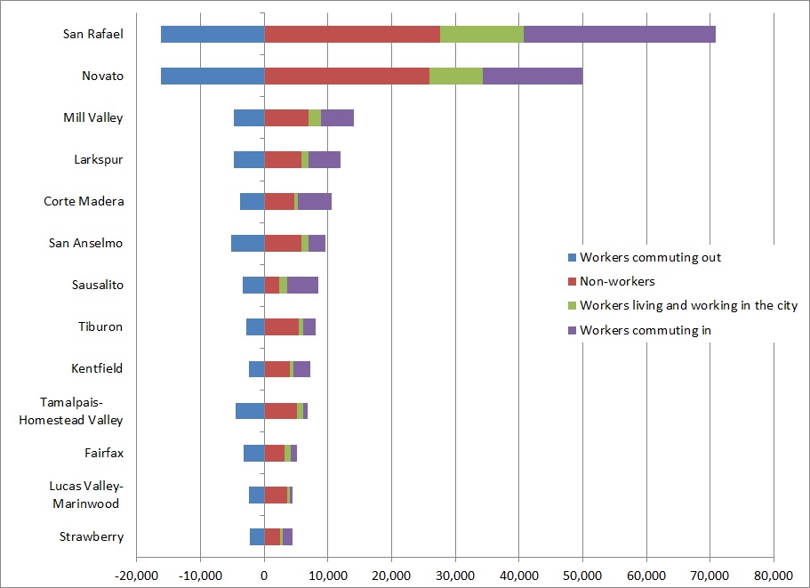
There is a sense, however, that Marin is a collection of bedroom communities. While this isn't true in aggregate, every town and place in Marin sends a large portion of their workforce off to work elsewhere.

Daytime Population-Employment Ratios

Most interesting in this regard are towns like Corte Madera, which actually grow during the day but whose local workforce overwhelming leaves the city during the day. While the place itself is a destination, the voting constituency sees its town as principally an origin rather than a destination. When asked to choose which transportation investments to make, they will probably choose the ones that will facilitate their own commute out of town rather than the investments that will facilitate the commute to their town.

Also emerging from this data is San Rafael's place as Marin's downtown. Its population grows by almost a quarter, more than San Francisco, from 57,000 to over 70,000. Novato, with a similar number of residents, doesn't change at all during the day, sending out as many workers as it takes in.

So what?

These data imply that most Marin commutes are between towns rather than between counties, as every town in Marin has more of their workforce leaving than staying while the county has a whole has more of its workforce staying than leaving. This has implications for Marin's transportation and housing planners.

First, it means transportation infrastructure investments should principally focus on short-hop transportation: bike lanes, better intra-county transit, and walk-appeal improvements. Each of these will encourage short-haul commuters to bike, take transit, walk, or any mix of those. This would leave roads and parking lots open for those who really need or want to drive.

Second, it means transportation officials should examine how to facilitate long-haul transit commutes. Morning transit from San Francisco to Marin is pitifully bad. Hour-long bus headways make sure someone is always either late or early, while Larkspur Ferry drops commuters off in the middle of a parking lot with minimal transit service. From Contra Costa, 28-minute headways are better but the travel time is longer than it needs to be. Midday headways get as high as 60 minutes.

And third, it means the linkage between housing and jobs growth is best done on a county-wide, rather than city-wide, basis. Municipal boundaries are arbitrary, and it's clear Marinites ignore them when it comes to jobs and homes. A Marin County subregion for RHNA allocations would make far more sense than the city-by-city allocations ABAG is now forced to make.

This new dataset from the Census will be extremely useful to the big cities, but it can also open a window into the behavior of our little corner of the country. Marin is maturing into a proper inner-ring suburb, drawing commuters all its own. Planners and residents need to shift their thinking, and their projects, to match that reality.

UPDATE: If you want to examine the data yourself, you can find full tables on the Census website. I've also isolated the Bay Area county data and the Marin town, city, and place data into a single spreadsheet. There have been some significant shifts since 2000 at the place level, but considering  margins of error on the 2010 data I hesitate to read too much into them for the smaller places.

Silvestri ignores the implications of his own data

Recently, Bob Silvestri, a proponent of auto-oriented, low-density development, argued that auto-orientation is more energy efficient than person-orientation and, therefore, superior. Yet his data, while implying that New York City or Paris are terrible polluters, does not support his thesis that Marin is the pinnacle of environmental quality. That's not to say his data doesn't have problems (it does), but let's take the assumption that he's measuring the right things and that the studies he cites are unimpeachable.

Houses, density, and greenhouse gases

Per-capita greenhouse gas emissions by development type. Image from Demographia.

Silvestri cites a (rather flawed) study (PDF) of greenhouse gas emissions per unit for a number of housing types, from high-rises to detached homes. Single-family detached homes were scored second best for all emissions in the Australian suburbs studied, with only town houses scoring better.

Simultaneously, Silvestri makes the quite important point that open space is a carbon sink. It's undeniable that the more open space we preserve as a region, the better off we’ll be from a sequestration standpoint. The EPA says open space takes in 2.5 metric tonnes of CO2 per acre per year (MTCO2/year), agricultural or recreational land takes in 1.5 MTCO2/year, suburban land takes in 1 MTCO2/year, and urbanized land takes in 0.2 MTCO2/year. Town homes, which lie somewhere between urbanized and suburban land, still leave plenty of open space in the back yard (often 50 percent). We need to estimate, but let's put that as 0.7 MTCO2/year. I will assume these numbers take into account commercial development patterns as well.

Silvestri measures San Francisco's net emissions against Marin's net emissions, but that's not the way to evaluate optimal conditions. It unfairly punishes San Francisco for having small political boundaries and rewards Marin for having expansive boundaries. Rather, we need to establish a baseline of nature and determine how different methods of development will change the carbon status of the same land area.

Two towns

So, we have 640 acres (1 square mile) of virginal open space producing a net negative 1,600 MTCO2/year. We'll people that with 100 households in a traditional suburban setting of about 4 homes per acre, which again will include commercial development. Using the average household size in the US, that means 259 people on 25 acres.

According Silvestri's Australian data for per-unit emissions, people living in suburban areas emit about 2.5 MTCO2/year apiece. With 259 people, our little town emits 647.5 MTCO2/year. Subtracting our sequester, which is now 615 acres of virgin land and 25 units of suburban, our square mile goes from a net negative 1,600 MTCO2/year to a net negative 915 MTCO2/year. Not too shabby.

Next door, another 100 families has set up shop on another square mile of land, but, inspired by Europe, these guys want a village of town houses at a relatively loose 25 units per acre. Rather than 259 people on 25 acres, this village will only use up 4. Since town home denizens pollute less than suburbanites, they're only emitting 518 MTCO2/year. Since they're living on less than a sixth the land area, there's more virgin open space to absorb their footprint. All told, the village goes to a net negative 1,075 MTCO2/year.

This other village, of course, will reap the other benefits of compact development. They will need to maintain fewer fire stations, fewer roads, fewer pipes, etc. Changes to travel patterns will mean less driving over the baseline and more walking, bicycling, and more transit users. That means they won't have to maintain large parking lots or such wide streets (which means more environmentally friendly stormwater management), and the citizens won't need to go to the gym to stay healthy.

As a bonus, with the money saved (and it would be substantial), they could electrify the whole transit system, rendering moot Silvestri's argument that transit as too carbon-intensive. Then again, a townhome-style city is ideal for cycling and walking, so there wouldn't be as pressing a need for transit anyway.

Far from supporting single-family housing, Silvestri should be supporting the kind of densities town homes provide, which can go as high as 60 units per acre. They are far more financially and space-efficient and less carbon-intensive than single-family homes. That's in his data, clear as the day.

I don't know why Silvestri would try to twist the data into saying something it doesn't, but the study itself does the same thing. The author, Wendell Cox, has done some good research on cities but has come to some odd conclusions: that suburbia as we know it is the result of free-market choices (it isn't, and is instead the result of $450 billion in annual federal subsidies) and that Seattle's suburbs are growing much faster than the city proper (they're not). I've found it's best to approach anything associated with Cox or his firm, Demographia, with a healthy dose of skepticism.

I hope Silvestri will join me and other urbanists in support of the kind of infill development that he has championed in the past. It offers a much better path to lower greenhouse gases than the Santa Clara-style sprawl his ideas advocate in the farmland and open spaces of Napa, Solano, and Sonoma.

What's the deal with San Rafael's one-way streets?

One Way Downtown San Rafael must serve a dual purpose. On the one hand, it is the walkable urban core of Marin, a major center of retail, culture, religion, and office space. On the other hand, it is the gateway between Ross Valley and Highway 101, and it has turned two of its five east-west streets (Second and Third) into high-speed, one-way arterials for that purpose.

Though these streets are repellent to pedestrians and, therefore, retail, the one-way travel conversion allows speedy and efficient access to the freeway, so at least they function well as glorified on/off ramps.

So why are B, C, and D streets, which run north-south, one-way, too?

Stockton City Limits wrote about Stockton's one-ways and offered up Jeff Speck's rationale for converting back to two-ways:

One-ways harm downtown in several ways: First, as one-way streets are designed to get cars to their destination as fast as possible, increased automobile speeds create a more dangerous and uninviting environment for pedestrians. Second, one-way streets distribute traffic unevenly, negatively impacting surrounding commercial activity. Businesses along one-ways suffer from a lack of visibility as drivers can quickly speed by without even noticing that a business is there, or only drive by once a day, either on their way into work or on the way back home.

That last point - that businesses suffer - is especially true for businesses whose storefronts face away from oncoming traffic.

Now, Second and Third, unpleasant though they are, at least serve their (too-limited) purpose well. Traffic is heavy to and from Highway 101 along those routes. Folks who remember the one-way conversion some 40 years ago recall those roads as congested when they were two-way.

But the lettered streets are all pain with no gain. There's no improvement to traffic flow because there is almost no traffic flow to improve. In the meantime, all they do is hurt business, confuse visitors, and provide a raison d'être to the ugliest Do Not Enter sign in the city.

Proposed Marin Transit signage a step forward

Bus stop signage is an important part of the transit landscape. It can offer a window into the often-opaque routes and numbers that can mislead or confuse inexperienced riders. To help make Marin Transit stops more accessible to the casual rider, MT has proposed a new set of signs for its shuttle stops, and the results are decent.

What's proposed

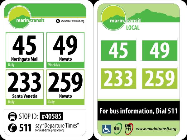
Proposed signage (left) and existing signage (right). From Marin Transit.

At the moment, the bus stop signage is limited to route numbers and some branding. There's a little bit of extra information, but for the most part it's assumed riders will use the map that's often on the flag to determine where buses go.

The proposed signage adds data and makes the route numbers more clear. Below the route is the destination, and below that are the service days. Though not frequency data - a valuable part of any bus map - it does allow a traveler to at least know that they shouldn't bother waiting for a route if it doesn't run that day.

Most importantly, the sign adds the stop ID and how to get real-time arrival information. Though GGT isn't there yet, MT already has real-time arrival data for the bus fleet it operates.

These are all excellent ideas, but there are problems when incorporating GGT's regional routes in the signage.

GGT's regional routes, however, do not get destination or service information. On the sample image, routes 40 and 42 are just big numbers without any indication that they're bound for BART. As well, the route number's box isn't colored blue, the color of Basic routes maps, which is out-of-step with coloration for the MT shuttles and GGT-operated local routes. While possibly a conscious decision, it is nevertheless the wrong one.

What have other bus systems done to aid riders with signage?

Practices elsewhere

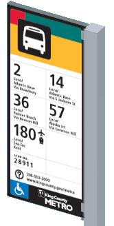
KCM Flag

Seattle's bus system underwent a similar redesign for its stop signage, and the result was similar, though there are differences. (See Seattle's design manual here.)

Most significantly, the Seattle stop signs use tiles, which allows the system to easily take out or edit route information as needed. If a bus used to be routed to the airport and isn't, Metro can just remove that tile from the route's signs rather than order entirely new signs. And, at the stops the route no longer serves, Metro can just remove the line's number. While more expensive than a typical sign, the tiles would save money over the long-term if service changes effect a large number of the metal signs.

Something else of note is the use of icons to show what services this particular route intersects. Marin's transit system includes ferries and airport shuttles and will soon include a train. Designating transfers to alternative modes may be of use. Designating routes that intersect the 101 trunk lines may also be useful, though that would involve a unified brand for such service. A black highway shield may do the trick.

London's bus stops use a similar design, but its bus stations do something a bit more horizontal, with more potential points of interest. If applied to Marin, Route 49 might list Civic Center, Lucas Valley, Hamilton, and Novato instead of just Novato. (You can find their design manual here.)

How's the sign?

My principal concern with the MT signage as proposed is that it does not visually integrate with either the GGT system or the MTC regional hub signage standards. This is problematic, as a unified brand for the transit system is important to rider literacy, especially for the casual rider. It makes little sense for them to proceed, as they did yesterday, without first developing a unified standard.

Given the prominence of the San Rafael Transit Center to the transit system, it would make sense to take inspiration from the signage there, which will meet MTC standards, rather than to invent a new visual language from scratch.

From a physical design perspective, it may make sense to design these signs to be modular. That would decrease the cost of route changes, as new signs wouldn't need to be stamped along with new route books.

Nevertheless, the new sign is still a step forward from what exists today. But it would be nice if MT would start thinking a bit more regionally.

If you want to offer input into the newly-approved signs, you can take the survey here.

Notes from Choosing the Future We Want

A week and a bit ago, I had the privilege of speaking on a panel entitled Choosing the Future We Want, thanks to a kind invitation from Sustainable San Rafael. I got to see a couple of the regular commenters beforehand, bust out some market urbanism and Charles Marohn afterwards, and talk about Marin's history as a transit-oriented county on the panel itself. Honestly, it was a whole lot of fun. It's much more rewarding to talk with people who are skeptical of change than to comment at them online. I hope I sparked some interest in suburban urbanism and shed some light on where our county comes from. I hope I'll have a chance to post about some of this in the future.

Below is the video in full. You can download Linda Jackson's presentation here and mine here. You can also download the maps of the Interurban either in the Map Room or on the original post.

One point of clarification. The last commenter said that if the examples I gave were representative of the kind of affordable housing we'd get under Plan Bay Area she'd be all for it. Lucky for her, every one of the latter building examples are affordable housing. That's not to say affordable housing is all grand in Marin (I'm hoping to write a piece highlighting some of the worst examples I came across while preparing for my talk), but it's a representative sample. We need people like her fighting for good development, not fighting against all development because some will be bad. We can't rely on design review boards and planning commissions to promote good design if all they hear from the public is negativity.

Okay, enough of my soapbox here. Go watch the video. I start at 50:22.

[youtube http://www.youtube.com/watch?v=ChM4dJy5M3Y]

Bus load of route detours this weekend

Planning on using transit this weekend? You may want to take a look at Golden Gate Transit's Detours page, because there is a ludicrous amount of stuff happening around Marin for the next couple of days. In short, routes 10, 19, 22, 70, 80, 101 will be effected at some point on May 18 and 19. Most of this will have tight parking or be in places where your car will turn into an oven, so transit will be the best way to get around, as long as you know where to go. And it might be a good idea to make Route 19 (or perhaps the ferry) your designated driver after the Tiburon Wine Festival. Here's what's up:

SANTA ROSA ROSE FESTIVAL PARADE, SATURDAY, MAY 18, 2013 On Saturday, May 18, from about 6:30am to 1:30pm, GGT Routes 80 and 101 will operate on a detour in downtown Santa Rosa due to the annual Rose Festival Parde. During this time, the Santa Rosa Transit Mall will NOT be served. Customers are directed to temporary stops at Fourth Street & B Street.

TIBURON WINE FESTIVAL, SATURDAY, MAY 18, 2013 On Saturday, May 18, from about 7am to 6pm, Tiburon Blvd will be partially closed due to the 29th Annual Tiburon Wine Festival. During this time, GGT Route 19 will NOT serve the stop at Tiburon Blvd & Main Street. Customers are directed to the nearby stops at Tiburon Blvd & Beach Rd or Tiburon Blvd & Mar West St.

MARIN-SONOMA CONCOURS TOUR D'ELEGANCE, LARKSPUR, SATURDAY, MAY 18, 2013 On Saturday, May 18, from 6am to 11am, GGT Route 22 will operate on a detour due to the annual Marin-Sonoma Concours Tour d'Elegance. During this time, the southbound bus stop at Magnolia Ave & Ward St will NOT be served. Customers are directed to nearby stops at Magnolia Ave & Bon Air Rd or Magnolia Ave & Madrone Ave.

SALUTE TO AMERICAN GRAFFITI CELEBRATION, PETALUMA, SATURDAY, MAY 18, 2013 On Saturday, May 18, from about 5am to 10pm, GGT Routes 80 and 101 will operate on a detour around downtown Petaluma due to the annual Salute to American Graffit Celebration. During this time, the following southbound stops willNOT be served: E. Washington St & Gray CirFourth St & C StreetPetaluma Blvd South & F StreetPetaluma Blvd South & Mountain ViewPetaluma Blvd South & Crystal LanePetaluma Blvd South & US Hwy 101 On-ramp. Also, the following northbound stops will NOT be served: Petaluma Blvd South & US Hwy 101 On-rampPetaluma Blvd South & Crystal Ln,Petaluma Blvd South & Mountain View AvePetaluma Blvd South & G StreetFourth & C Streets, and E. Washington & Petaluma Blvd North. Customers are directed to the Copeland Street Transit Mall.

ASIAN HERITAGE STREET CELEBRATION, SAN FRANCISCO, SATURDAY, MAY 18, 2013 On Saturday, May 18, from about 5am to 9pm, GGT Routes 10, 70, 80 and 101 will operate on a detour in the SF Civic Center area. During this time, the following southbound bus stops will NOT be served: Golden Gate Ave & Polk StHyde St & McAllister St, and Hyde St & Grove St. Also, the following northbound stops will NOT be served: 7th Street & Market StreetMcAllister St & Hyde St, and McAllister St & Polk St. Customers are directed to nearby stops at Mission & 5th Streets or Van Ness Ave & Turk St.

AMGEN TOUR OF CALIFORNIA, SANTA ROSA, SUNDAY, MAY 19, 2013 On Sunday, May 19, from about 6:30am to 1:30pm, GGT Routes 80 and 101 will operate on a detour in downtown Santa Rosa due to the AMGEN Tour of California bike race. During this time, the Santa Rosa Transit Mall will NOT be served. Customers are directed to temporary stops at Mendocino Ave & College Ave.

BAY TO BREAKERS, SAN FRANCISCO, SATURDAY & SUNDAY, MAY 18 & 19, 2013 On Saturday and Sunday, May 18 and 19, GGT will operate on separate detours in downtown San Francisco due to the annual Bay to Breakers 12K race:

  • On Saturday, May 18, from 9pm until about 3am on Sunday, May 19, the northbound stop at the Temporary Transbay Terminal and ALL southbound stops on Howard Street will NOT be served.
  • On Sunday, May 19, from 3am until about 12pmALL southbound trips will END at Golden Gate Ave & Polk St andALL northbound trips will BEGIN at McAllister Ave & Polk St. GGT will operate a shuttle between the Civic Center (Golden Gate Ave & Polk St) and Mission & 2nd Streets. The southbound shuttle will drop passengers off at Muni bus stops along Market Street; the northbound shuttle will pick up passengers at stops along Mission St. Fares will NOTbe collected on the shuttle. NOTE: during this detour, GGT will NOT operate on Folsom, Fremont or Howard Streets.