Boost connectivity with integrated scheduling

The principal problem with Larkspur Ferry parking is really that it has poor connections to other modes, especially bus. Though there used to be a shuttle system in place, it didn't do well and was cut years ago. While the Wave has taken a step toward reintroducing the shuttle, Golden Gate Transit has ignored regular bus service from the 29, as well as daytime and weekend trips to and from the ferry. To help riders get a visual of their options, I've created an integrated bus/ferry schedule (PDF) for routes 17, 25, 29, and 228 - all of which serve Larkspur Ferry Terminal at some time or another. The Interurban light rail schedule (PDF) did the same thing with the Sausalito Ferry.

On the weekdays, what stands out to me is the very long connections for people coming from San Francisco. Though the 29 does pretty well for those heading to the ferry during the day - most require waits of only 10-15 minutes - it's awful for connections from the ferry. Most connections are between 20-30 minutes, a couple leave only a minute to spare, and just a handful are in the sweet spot between 5 and 10 minutes. Optimizing the time points between the bus and ferry could boost ridership all on its own, without any need for new service.

Study the schedule yourself and you'll see what I mean. And, if you're a frequent ferry rider, print it out and keep it in your schedule book.

Mill Valley tries free parking downtown

Free parking spaces in Mill Valley. Image from the city of Mill Valley. Free parking has, over the last decade, been identified as a major cause of sprawl, tax wastage, and traffic. San Francisco’s pioneering SFPark program, which attempts to price parking according to demand, has found that a well-managed parking supply can decrease traffic, increase retail sales, and even increase the availability of spaces.

Downtown Mill Valley is running an opposite experiment of sorts with 30 of its downtown parking spaces. PG&E will be replacing a significant amount of pipe downtown for weeks, taking 8 spaces out of commission and causing major disruptions to the usually bucolic town center. To counteract that, Mill Valley has made 30 spaces – a hefty fraction of its on-street parking – free from April 14 to May 2.

The research

I’m sure you’ve had the misfortune of circling endlessly for a parking space, only to have the one you spotted snatched up by someone in front of you. Research from UCLA’s Donald Shoup has found that such circling accounts for up to 30 percent of traffic (PDF) in dense areas.

This is a problem. The more time people spend hunting for a parking space (average is around 3 minutes), the less time they’ll want to spend at local shops. And, the more painful the search for a space, the less likely people will want to come back.

The culprit is underpriced parking.

When SFPark started operating, the aim was to leave at least one space available on every block by adjusting the price of parking. SFPark measured occupancy by each block and raised or lowered prices incrementally one space was free per block.

After three years, SFPark has decreased traffic, increased turnover, and – for the most part – accomplished its aims. The number of parking tickets has dropped and even the average price to park fell. This validates Shoup’s theories in a major real-world setting.

The plan

The 30 spaces Mill Valley has made free are funded by PG&E and the local Chamber of Commerce, as the city relies on the income from parking meters for its general operations.

Though there was apparently some talk about reducing bus fare to downtown, Chamber officials told The Greater Marin that PG&E didn’t give them enough of a heads-up to coordinate with another agency, and they’d rather do half of something – give free parking – rather than do nothing at all.

Unfortunately, Mill Valley isn’t using this as an opportunity for research. Because only a few of the parking spaces will be free, those will be at a premium. Will it cause more circling in the free area? Will it decrease turnover?

While the Christmas seasons’ free parking offers a great experiment for the whole downtown, it would be incredibly useful to understand how setting the price of parking at $0 for only a few spaces would affect downtown demand. It would also show whether this sort of program is a useful incentive to shop downtown or if it’s just going to muck things up more.

Given the research on parking policy, it seems unlikely the two-week program will lead to anything like the efficiency downtown Mill Valley will need with PG&E’s construction. I suspect there will be people circling around for the free parking spaces and lower turnover than normal, though without data we’ll have no idea whether that’s true or not.

It seems rather more likely that the program’s advertising aims – to let potential customers know that yes, indeed, Mill Valley is still open for business – will be the big win. The Chamber of Commerce will gather anecdotal evidence from its member merchants about what worked and what didn’t, and we’ll have to see what can be gleaned from that when the program ends.

In the meantime, be sure to take Route 17 downtown. They could use the business, and I suspect they’ll also need the parking spaces.

Bus commuter schedules no longer reflect demand

Though by all accounts Golden Gate Transit's commuter bus system is quite popular, it is increasingly out of touch with the commute times of Marin's modern workforce. Marinites leave for work later, but GGT continues to operate with early-morning service. FiveThirtyEight recently took Census data and determined which metropolitan areas get to work the latest. The San Francisco metro area, of which Marin is a part, got fifth on the list, with a median arrival time of 8:17am but a 75th percentile arrival time of about 9:30am. The bottom of the range is about 7:45am.

Just after reading this, reader John Browne, a frequent rider of the last Route 18 from Kentfield, tweeted:

It turns out John Browne is right.

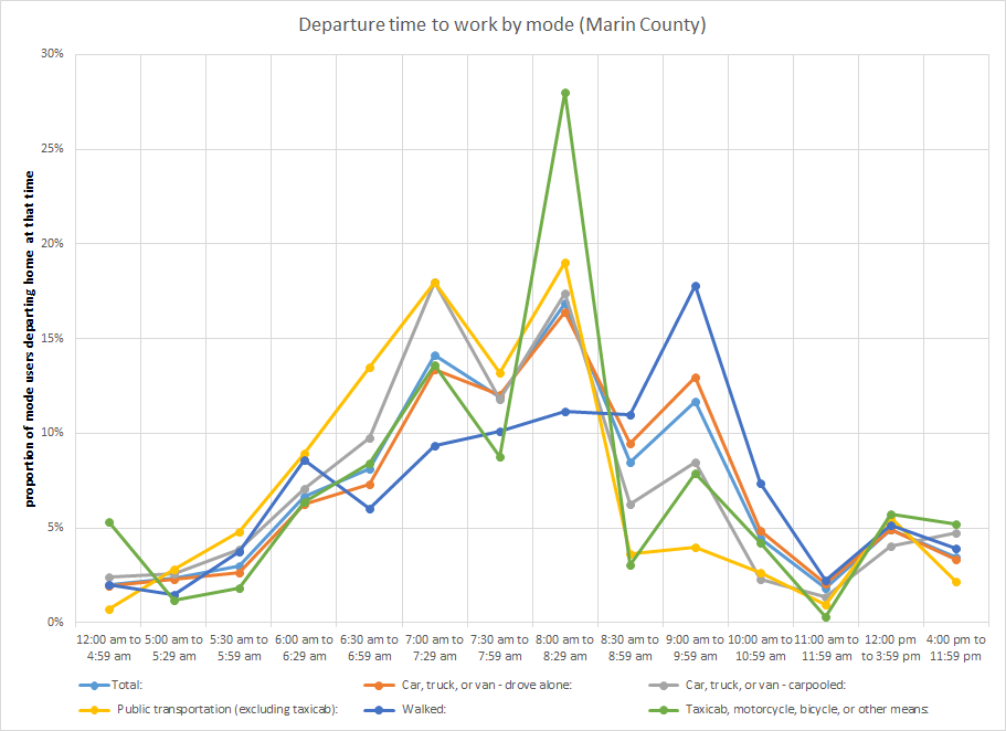
Using the same Census data FiveThirtyEight used (though without the math to convert it into the ranges author Nate Silver did), I plotted out the average departure times for Marin commuters taking all modes to work. Transit commuters leave work at roughly the same rate as others up until 9am:

Yellow is transit.

The proportion of transit riders leaving home between 9 and 10 stays down after the drop from 8:30 to 8:59 while other modes pop back up.

A glance at the span of service for Marin's commute buses makes it easy to see why that might be. On average, the last Marin stop for a Marin commuter line is about 8:27, while the average last departure is a bit earlier at 8am. In other words, if you want to get out of Marin by bus, you're probably going to have to leave home before 8 or 8:30, and that's exactly what shows up in the Census data.

GGT should reexamine the county's travel demand and which final buses are the most crowded and aim to add service to those lines later in the morning. Adding to service span will scoop up riders that want to leave later, and can also give earlier riders the peace of mind that they can leave later if needed, helping shore up ridership earlier in the morning, too.

It's not just tech workers that are leaving later in the day, it's Marinites in general. Our transit system should start scheduling for that.

Even as bridge tolls increase, gap with fares widens

This week, tolls increased on the Golden Gate Bridge for the first time in 6 years, to $6 with FasTrak. Though there was some grumbling and a bit of consternation from drivers who now need to deal with a more expensive commute, these cost hikes are no stranger to transit riders, who have faced annual fare increases for over a decade. A quick look at the discount toll and average discount fare (adjusted for inflation) starts to get at the picture:

Inflation-adjusted fares and tolls in 2014 dollars through 2018. Notice that the fare's increase is not linear, which is because the annual hikes are percentage-based, not dollar-based like the tolls.

Though it's obvious from above, the point is best expressed from the ratio of fares-to-toll:

Ratio of the average round-trip discount transit fare to the average discount toll, through 2018. Notice that the gap still increases despite annual toll hikes.

In 1992, the average round-trip bus fare was 1.62 times the discount toll. That ratio reached a high of 2.44 last July 1, when the latest fare increase was made. Now that the tolls have gone up, the ratio has dropped to 2.03, the lowest it's been in 5 years, but that will be transitory. On July 1, when fares increase another 5 percent, the ratio will head back up again, to 2.14.

If fares continue to increase 5 percent every year, that ratio will continue to widen, even with annual $0.25 toll hikes, to 2.22 in 2018.

Strictly from an equity perspective, this is unjust. Bus riders tend to be lower-income, and so have a more difficult time taking fare hikes, while the opposite tends to be true of drivers. Not only that, but others who can't drive - those who are blind, albino, elderly, and others - are disproportionately hit by fare hikes.

By pushing away those who have access to the driving alternative, too, the fare hikes render transit more and more into a second-class social welfare service rather than the first-class transportation service it could be.

From a technical perspective, those new drivers adds to congestion at the rush hours, forcing everyone, rider and driver alike, into a slog every morning and night. It's a terribly inefficient transit system, destroying any advantage of having a freeway. San Francisco, Sonoma, and Marin all suffer.

Narrow goals lead to bad outcomes

The Golden Gate Bridge, Highway, and Transportation District (GGBHTD) has as its explicit goal that fares should cover at least 25 percent of bus operations and 40 percent of ferry operations. By raising fares regularly, GGBHTD is trying to hit that moving target. Bus ridership has dropped dramatically since 2000 and with it has fallen transportation income, while operating costs have jacked up the price of providing service.

To compensate, GGBHTD has hiked fares every year since 1998, boosting inflation-adjusted fares 82 percent.

The problem is that GGBHTD isn't thinking like a business, where income is more than just a function of price, and it's not thinking like a government agency, with broader societal concerns than mere income. The end result is a nonsensical and unjust policy of never-ending fare hikes far beyond inflation and ever-slower commutes.

Broaden the goals, reformulate the prices

The core technical mission of GGBHTD should be to help prevent congestion in the areas most immediately effected by its policies, namely Central and Southern Marin, and work with the transit and congestion management agencies in San Francisco, Marin, and Sonoma to prevent or mitigate it in the rest of its commute shed. This would fit with the original founding purpose of Golden Gate Transit, which was to resolve congestion on the Golden Gate Bridge.

To ensure its historic, technical mission is fulfilled, GGBHTD needs to rework its pricing scheme with congestion in mind. This will mean tolls will rise, but not necessarily too much. If fares stay flat or even decrease, that daily congestion toll may not need to rise nearly so much to ensure congestion is alleviated. Physical changes, such as creating carpool lanes on 101 as far as Lombard in San Francisco, will also help mitigate congestion and, therefore, that toll hike.

The core social justice mission for GGBHTD should be to ensure transit is a tool of freedom for the poor and car-free, rather than make this one more way they can't succeed. This would fit with the original purpose of having Greyhound take up the transit slack once our light rail system was put out of business by GGBHTD.

Yet progress is made in this equally historic social justice mission simply when GGBHTD meets its technical mission, which by necessity will decrease the fare/toll gap. If the district invests the new toll revenue in more frequent bus service and better bus infrastructure, it will elevate raise the prestige and enjoyment of using the bus system.

Finally, GGBHTD's efforts will increase ridership (and therefore fares), to meet its new mission of keeping fare revenue in sync with operating costs.

The ever-rising gap between fares and tolls is symptomatic of deep dysfunction in the heart of GGBHTD. An obsession with a single metric - revenue - has led to an incredibly inefficient transportation system and caused the district to fail in the missions it was founded to accomplish. Drivers, riders, the poor, the rich - all suffer under this scheme.

*As Golden Gate Transit doesn't keep historic bus and ferry fares available online, rather just fare increases, this is backwards-calculated from the average cost to travel from the North Bay to San Francisco on bus and ferry. GGT also doesn't keep historic fare increases available from before 1993.
Marin is growing, and not slowly

Marin County’s population grew by 1 percent from 2012 to 2013, slightly faster than the state and much faster than the country at large. The new numbers challenge the concept of Marin as a naturally slow-growth county. In total, Marin added about 2,500 people in 2013, bringing our population up to over 258,000 for the first time. If we keep up the pace, we’ll break 260,000 in 2014.

Our growth rate is 0.1 percentage points faster than California, which grew by 0.9 percent between 2012 and 2013, and 0.3 percentage points faster than the United States as a whole. It’s 0.3 points slower than the Bay Area at large, however, which was driven by swift growth in Alameda and Santa Clara (1.6 percent and 1.4 percent, respectively). Instead, rather than tracking with San Francisco, Marin grew at a rate typical of North Bay counties: 0.9 percent in Sonoma, 1.1 percent in Solano, and 1 percent in Napa.

This is far faster than our historic growth rate.

Between 2000 and 2010, Marin only added about 5,000 people in total, an annual growth rate of just 0.2 percent. In just 3 years, from 2010 to 2013, however, we added almost 6,000 people, an average annual growth rate of 0.7 percent.

Most of our newcomers were not new births but migrants. Natural increase – births minus deaths – accounted for less than 20 percent of the new population. Net migration accounted for the rest, showing that we aren't a county of young, growing families.

While full demographic information for 2013 won’t be out until later this year*, results from 2012 showed that Marin has been steadily aging, with a new median age of 45.2, up from 44.5 in 2010. Marin is already the oldest county in the Bay Area with the most bedrooms per person, and this is likely not to decrease.

It will be interesting to see if these trends continue. If so, it will provide strong evidence that Marin is leaving behind its traditional role as a family-centered suburb and instead is entering a prolonged period as the Bay Area's retirement community. If this year bucks the trend, then perhaps a future of rich retirees is not quite written in stone.

Either way, the slow-growth narrative is challenged by this past year's growth. We are growing far faster than we did in the past decade, much more in line with the region and even faster than the state. It will be interesting to see how county leaders and activists respond.

*Once 2013 demographic data is released, we will revisit the analysis published in 2012: age, household size, household growth, units, bedrooms, rents, and household income.

Update: The source of the population growth figures is the United States Census, which estimates population each year for every county in the country.

Optical illusions on Fourth Street

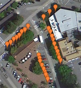
While working on a piece about bike lanes, I stumbled across something odd that says a lot about how the built environment influences perceptions. Downtown San Rafael. Image from Google Maps.

A pet peeve of mine for years has been Fourth Street through West End in San Rafael. The neighborhood has struggled for years under the shadow of downtown, hidden just over a short hill, and street width is part of the reason I rarely spend time there. It just doesn’t feel cozy like downtown. Downtown is above this paragraph, West End is below.

San Rafael's West End

So when I got back street width data from city hall, I made a double take. Fourth Street through West End, which runs from H to E streets, was actually narrower than the rest of Fourth all the way to its end at Union, by up to 10 feet: 40 feet vs. 50 feet.

So why does it feel so much wider? Look again at the two pictures and you’ll see some stark differences. In downtown, the trees are older, the street parking is a bit fuller, and the buildings on both sides of the street cozy right up to the sidewalk. In West End, the buildings only cozy up to the sidewalk on one side of the street, with parking lots and show leading way back to squat buildings on the other side.

Those parking lots make the street appear significantly wider than it actually is, creating an optical illusion. I can’t think of a better example of how walkable development influences our sense of place better than this.

Red light cameras are good policy gone wrong

Red light cameras have been deployed around the country to great effect, reducing crashes dramatically in New York City and Washington, DC. Given these successes in the East, it was natural for San Rafael to give them a try. But police said they were ineffective at reducing crashes, and that they cost more than they took in, so the city recently ditched them. Given state law in California, the results in San Rafael start to make some sense.

Best practice: red light cameras

Traditional traffic enforcement is meant to be punitive. Police can’t be everywhere, so, to change behavior, any violation caught needs to be punishing and painful. As a result, California has extremely high fines for red light violations: a minimum of $489.

When a city switches on red light cameras, they generally try to limit them to key intersections. This ensures that most dangerous violations are caught, even if other violations at less important or less dangerous intersections are missed.

Psychologically, this is not effective, as it does not create a culture where traffic violations are simply not done. Serial red light runners will continue to do so wherever they like, just avoiding the two or three intersections where they know they’ll get caught. Research finds dummy cameras, which flash a light but take no picture, are effective at stopping red light running, a strong indicator that running lights is often a conscious decision.

To change behavior, one must apply a little force consistently, not a lot of force inconsistently. Red light cameras, when seen in this light, don’t do a very good job. They should be ubiquitous and cheap, with a relatively low-dollar ticket – maybe just $150 – that hits a driver for every red light run.

California’s red light ticket minimum means ubiquitous tickets would add up rapidly. As it is, just one $489 ticket can be half of someone’s take-home pay for the month, or worse. It’s unjust to use such a painful instrument to change behavior city-wide, even if the end of crashes prevented is noble.

As well, the high ticket fine opens cities up to criticism that traffic enforcement is simply a money grab, a politically toxic accusation that could kill any such comprehensive enforcement.

San Rafael’s experience

Without the flexibility to catch red light runners every time, San Rafael’s experience with cameras was a poor one. Though a 2012 grand jury report found crashes declined by 12 percent up to that point, a police spokeswoman told me crashes increased by 1 fatality.

The managing company, Redflex, was also a political headache. The IJ's Megan Hansen reported, “Redflex has been losing contracts ever since it came under fire early last year when news broke the company was being investigated for corrupt business practices, including bribery and secret meetings.” Red light cameras are never politically easy, and paying a potentially corrupt company hundreds of thousands in taxpayer funds and ticket fines just makes things worse.

Though traffic enforcement is vital to creating a safe environment for all road users, San Rafael should focus its efforts on street design rather than automated enforcement. Though the impulse among some may be to keep fines high, road safety advocates should advocate for laws that do the most good, not just the ones that feel right.

To that end, California should create a two-tier system of ticket enforcement: one with dramatically lower fines for comprehensive automated enforcement schemes, and one with the existing fines for the spot-checking enforcement schemes cities rely on today.

Though it’s unfortunate San Rafael did not get a good deal for its cameras, removing them was ultimately a response to bad state law. Perhaps one day the city will be able to install a system that changes how we think about traffic laws, but until then it’s probably best to just go without cameras altogether.

Marin’s transit ridership in step with national trends

Public transit ridership in the United States is higher than it’s been since 1956: 10.7 billion trips, up 1 percent from last year. While this indicates an overall trend toward transit, it’s been driven largely by high-quality transit: heavy rail like BART, commuter rail like Caltrain, and light rail like Muni Metro. Marin County’s transit picture largely echoes the national trend, though this is not a new story for our county. High-quality transit, namely trains elsewhere but ferries here, continues a ridership boom, as has commuter bus service, but local bus ridership continues to slowly slide. Overall, Marinites are taking more transit.

Local bus

Golden Gate Transit’s Marin-only service has been bleeding passengers for the past five years, from about 4.1 million to roughly 3.3 million today. Including Marin Transit’s independent operations, such as West Marin Stagecoach and school service, local ridership ticked down by 0.7 percent over last year, to 3.4 million trips.

Regional bus

Golden Gate Transit’s commuter and basic routes to San Francisco, however, are doing quite well. For the past 32 months ridership has grown and, year on year, grew by 1.3 percent over January, 2013, to about 2.5 million trips. This, however, is still down from 2004’s 3 million trips.

Ferry service

All that changes when you include the ferries. Despite a steep price hike in 2003, ferry ridership has been growing like gangbusters. Even excluding Sausalito, whose figures are skewed by tourists, Larkspur’s ridership growth has been more than enough to offset the long-term decline in regional bus ridership.

Larkspur ridership grew by 7.3 percent in the past year, from approximately 1.5 million trips last year to about 1.6 million this year. Sausalito ridership grew twice as fast, 14.9 percent, though at around 750,000 annual trips it’s still a small share of total ridership.

The rapid growth in the ferry system continues a now-32 month growth streak begun in 2011. It shot through its all-time record, set in 1978, in 2012, and shows no sign of slowing down.

What it all means

The national trend toward transit is really a national trend toward quality transit. Buses that come every hour and take 4 times as long to get around as a car just don’t cut it.

Indeed, even as MTC has focused a huge amount of attention and money on moving people faster in cars, it has spent almost no time focused on moving people faster on transit. BART is the only major investment in the past half-century that has dramatically improved mobility through the Bay Area, but has now been expanded to areas that do little to boost ridership. Other booming systems are those that feel higher-class or that run as fast or faster than driving, such as Caltrain.

In that light, it’s no surprise Marin’s high-class transit service, the ferry, is doing so well. So too is it no surprise that commuter buses, which generally offer a nicer ride than local buses, are steadily growing as well. Combined, the two systems grew by 3.5 percent this past year, quite a bit faster than Golden Gate Bridge traffic, which is up 2.4 percent.

These and national trends should guide GGBHTD and Marin Transit as they choose their capital investments. Big investments in the bus system should focus on speed, for both the locals and commuters, and comfort, for the commuters. Signal priority, for example, which allows approaching buses to turn red lights green, would help make schedules more reliable and make the bus more competitive against the car.

Small investments should focus on usability and connectivity. Open-source real-time arrival data for all buses, for example, would be a huge boon for riders, dispelling the anxiety one gets waiting for an infrequent bus to come.

For ferries, their extremely fast growth rate means capacity problems are on the horizon. GGT needs to start laying the groundwork for more crossings from Larkspur. Ongoing problems with midday ridership will continue to be a roadblock to better service as well. Even faster-growing ridership at Sausalito may require more ferries to meet the demand.

Marin's experience shows national trends are indeed applicable to our county. Investments in usability, in connectivity, and in higher-quality trips would capitalize on overall demand for transbay travel, while investments in frequency and speed could stop the slide of local service. Transit planners here would do well to learn from the successes of others.

Substandard bus stops drench, humiliate riders

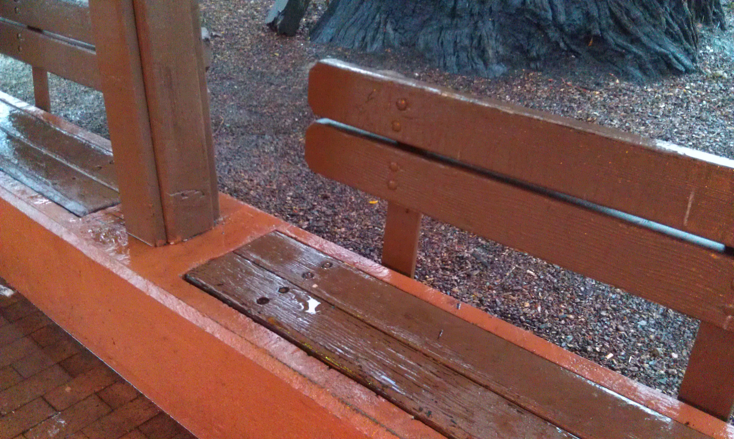
A soaked bench at the Depot. Image by the author. During Marin’s big Pineapple Express a few of weeks ago, I had the pleasure of taking the bus all over Marin. Stepping off a bus without worrying about parking or gas or finding the car always feels liberating to me, so I thoroughly enjoyed that aspect. But thanks to bad stop design, I and my fellow riders got soaked.

After chatting up some of protestors of WinCup, I walked along the narrow sidewalk to the closest southbound bus pad, not just to see what the walk was like but also because I had to get to Mill Valley. Aside from protestors using up the entire sidewalk width, forcing me to walk in the street, it wasn’t so bad. The bus pad, though, was another story.

The bus pad shelter allowed the wind to whip rain right in the face of me and my fellow travelers. The bench was so soaked that sitting would have made for a cold and soggy experience. Someone else waiting spoke very little English but pointed at the rain and the bench and laughed. "Very wet," she said, and it was quite clear she thought the situation was ridiculous. Though she was heading to Mill Valley, too, she hopped on the next bus that came (Route 36) just to get out of the wet. I decided to stick it out, though, and my Route 17 bus arrived soon enough.

Alas, the Mill Valley Depot, central bus station of this most wealthy of towns, was in even worse shape. The roof dripped everywhere, soaking not just the benches but anyone who risked standing under it without an umbrella. Water trickled in from every slat in the roof and positively poured in through the light fixture.

The state of repair on the Depot and the quality of the bus pad stops tells riders, You don’t really matter. For one of the wealthiest counties in the country and one that prides itself on being green and supporting the less fortunate, that’s unacceptable.

If buses are a travel mode of equal stature to the car or ferry, bus stops – especially signature stops like the Depot – need to be treated like it. They should be comfortable, or at least bearable. The people who ride the bus for work or out of necessity do matter.

Anti-smart growth advocate defends urbanism

It's not often you'll find people arguing against smart growth while also arguing for urbanism. When it happens, one wonders if it was a mistake. That seems to be the case with a screed penned by Lawrence McQuillan of the Independent Institute in Oakland, though his argument is worth highlighting. While arguing that density isn't a very effective way of decreasing greenhouse gases, he makes the market urbanist argument I've made time and again in this blog:

If governments ended their war on home construction, builders could buy the land they need to construct the housing that local people want, not housing that politicians and smart-growth activists want. That would increase the stock of affordable housing and help the environment too.

While McQuillan digs at smart growth, his critique more aptly applies to our country's existing urban policies. We have spent so long trying to structure and restrict where and how our cities grow, especially within already built-up areas, we've made our cities totally unaffordable for those who want to live there and our suburbs too far from the core for those who want the big-yard, drivable lifestyle.

McQuillan adds: "[H]ere lies the folly of government master plans to control growth. People are not chess pieces to be moved about at the will of politicians and bureaucrats. People have dreams and aspirations for themselves and their families." And yet through policies that have been in place for over 60 years, politicians and bureaucrats have played a helluva lot of chess with our lives.

If governments like those in Marin lifted density and parking controls and focused instead on maintaining small-town character, if they stopped artificially segregating commercial and residential uses, if the federal government stopped its $450 billion annual subsidy for single-family home development*, if the state stopped subsidizing 70 percent of road maintenance and construction with sales taxes and other non-user fees, perhaps we'd see some equilibrium return to our transportation and housing markets. We wouldn't need regional housing quotas or ABAG or affordable housing grants because the housing market would simply meet the demand.

It's unfortunate that only one kind of government intervention - the kind he doesn't like - is the target of McQuillan's ire. The massive and ongoing interventions in our real estate market deserve just such a libertarian flaying.

*Yes, that's almost a half-trillion dollars every year in direct and indirect subsidies for single-family home development.

Hat tip to Save Marinwood for the article.

Kickstarter to document the world's changing streets

Our streets are changing. There are more bike lanes for more bikers, better sidewalks, better streetscapes. You can see it in Fairfax near the Good Earth or any time you're in San Francisco. But how are they changing, and why? How are cities learning to finally deal with congestion and accommodate other modes of travel? Todd Drezner wants to take a look, but he needs a little help to move beyond New York City. He wants to film across the United States and even take it international.

You can watch the trailer here.

The Kickstarter fundraiser ends tomorrow at 5pm and, as of this writing, he still needs about $2,000 to make his goal of $25,000. If he doesn't make it, he gets nothing. If he does, he gets the full amount. If you're as interested in the intersection between travel and urban design, maybe you'll want to give to make sure it happens.

A counter-petition starts in Strawberry

A new petition – still small – is trying to inject some sense into the Strawberry priority development area (PDA) debate. It’s about time. The core contention of the petition is simple: the PDA is not about housing, it’s about transportation funding. To cut out the transportation funding just eliminates transportation funding, leaving any housing plans intact.

The success of Marinwood activists has been the removal of the PDA but intact housing plans. The success of North San Rafael activists was the removal of the PDA but an intact station area plan. What did they accomplish? Political victories that do nothing to advance their stated goal of downsizing housing plans.

What’s a PDA again?

As I’ve written before, a PDA, or priority development area, is a funding mechanism for a part of the region. It’s entirely voluntary and entirely without strings attached. Half of Marin’s transportation dollars must go to a PDA.

At the moment, the regional funds dedicated to PDAs are for planning, so shovels can’t go in the ground, but that just means we can start the process of building real improvements to the county’s transportation infrastructure.

What is the PDA not?

Critics, including frequent commentor on this blog Richard Hall, will point to the application process, which requires an area to have plans for more housing before it can become a PDA, to say that a PDA by definition is a housing plan.

But that’s like saying a credit card, by requiring a certain income level on the application, is income. Of course that’s ridiculous. You had your income before the card. In the same way, any housing zone or plan must be before and, therefore, separate from the PDA.

That’s why anti-housing activists have seen such failure in their stated aim of stopping housing plans.

Conflict roils Strawberry

There are two housing plans that are causing discord in Strawberry: the Seminary housing plan and the county’s housing element. Of these, the Seminary housing plan is what qualified Strawberry to become a PDA first place.

The arguments against housing are diverse but familiar – it would destroy the character of the area, add to traffic congestion and school crowding, cause crime and bring in the wrong kind of people.

Added to the mix are long-running concerns over the existing traffic. The roads in Strawberry are unsafe for anyone who isn’t in a car, especially Belvedere Drive and Tiburon Boulevard. If there are more people, the thinking goes, the problems will get even worse.

Simply put, every one of these arguments is not germane to the discussion of a PDA. Even if housing did do all these things – and, if they did, Strawberry’s high rate of rental housing would surely correlate it to having the worst crime in the county – housing plans are separate from the PDA.

Indeed, remaining within the PDA would provide money to start fixing the problems Strawberry has. Starting grants totaling $210,000 would pay for a comprehensive study of bike and pedestrian infrastructure needs in the area as well as designs for a new Tiburon Boulevard interchange.

Exceptional needs

There are serious gaps in the walking and biking infrastructure throughout Strawberry, and some of it has been the target of quite a bit of ire from local families.

Redwood Highway, Seminary Drive, Belvedere Drive and Reed Boulevard all have no consistent bike or pedestrian infrastructure. Belvedere Drive especially is a fast and dangerous road. Some segments lack sidewalks and all of it is bereft of bike lanes.

Considering that it is the principal route for kids walking from the park to the shopping center, it is an accident waiting to happen. Calming the road with more and better sidewalks and shallower turns has been on the agenda of the neighborhood for years. The PDA is the best chance to make that happen.

Tiburon Boulevard: why it matters to the rest of Marin

The interchange is the biggest project in the area. Caltrans wants to install metering lights at most interchanges up and down the 101 corridor to smooth traffic flow, especially during the evening commute. Tiburon is the start of the nightly Greenbrae corridor mess as service workers leave jobs on the peninsula and head home to Contra Costa.

With a PDA, the Tiburon interchange will be eligible for regional funding, ensuring the project will finally go forward. It would also give leverage to local needs, such as a safe bike path and sidewalk across the bridge and bus pads that don’t require riders to walk across a freeway off ramp. Caltrans has historically been quite hostile to these concerns, so any advantage in negotiating with them could go a long way.

Improving the Tiburon interchange is a project of countywide importance, as it’s key to breaking the Greenbrae Corridor jam. As well, improving that bridge would allow students to finally bike or walk to school in safety, helping ease school traffic through lower Mill Valley. Remember that traffic flow tends to drop off rapidly beyond a certain point; a drop in car travel of even a few percentage points can have enormous impact.

Time to stop fighting shadows

Citizen Marin and the (newly formed) Strawberry Community Association have done Strawberry a grave disservice by spreading myths and fear about their local PDA. Their petition is full of the patently absurd, arguing that the PDA would be a tax giveaway to developers and threaten endangered species.

It’s a glimmer of hope in this never-ending, fearful, angry debate that some people have stood up to say enough. Perhaps you’d like to sign up and join them.

Walking is key to smart planning

The concept of transit-oriented development (TOD) has been thrown around Marin for years, and for good reason. The idea is that by putting new homes near transit, fewer people will drive and more people will take transit to work. This, coincidentally, is Marin's experience.

Marin's towns were built with the understanding that most people would take the old light rail and ferry to work, and so we did. Though the light rail is long gone, our homes, businesses and transit hubs stayed put. As a result, Marin is one of the most transit-happy counties in California, trailing only San Francisco and Alameda in the percentage of its people commuting by transit. One in four people heading across the Golden Gate Bridge in the morning are on a bus.

Perhaps, though, it is understandable that IJ columnist Dick Spotswood would overlook the ongoing success of TOD in Marin. This transit-friendliness doesn't seem to extend to the daily lives of Marinites, which often revolve around driving for all our errands. It's so obvious to him, in fact, that he calls TOD "greenwashing."

But Spotswood missed the secret power of transit-oriented development. It's not the transit. What is it?

Continue reading on Marin IJ.

Options floated for toll hikes on the Bridge

by Stephen Woods, on Flickr At long last, the Golden Gate Bridge, Highway, and Transportation District (GGBHTD) will be hiking tolls. While this is a good thing for the North Bay’s transportation system, the rationale shows that GGBHTD still doesn’t understand its opportunities or how to plan for a better transportation system.

The toll hikes are designed to boost revenue to GGBHTD’s coffers to offset the massive debt incurred by rebuilding Doyle Drive. In a sense, this is exactly what the toll was designed to do: offset construction and maintenance expenses associated with the Golden Gate Bridge. In another sense, though, the district is giving up on an opportunity to cut traffic along with raising toll revenue. Nowhere is a demand-based toll in the works, and that means a huge missed opportunity.

Demand-based tolling

A demand-based toll, more commonly known as a congestion charge, sets a price to cross into a particularly congested area with the aim to keep traffic free-flowing within the cordoned area.

San Francisco has explored a few options. Five years ago it tried to work with GGBHTD to establish a demand toll on the Golden Gate Bridge, but it was shot down by then-San Rafael mayor Al Boro, who called it a “Marin commuter tax.” (I don’t recall him being so upset about the annual 5 percent transit fare hikes that took its place.)

San Francisco shifted to examine its southern border with San Mateo County but faced pushback there, too. It was clear San Mateo saw this as a punitive measure against its citizens and promised countermeasures, including its own demand toll for San Franciscans commuting to San Mateo. (Given the congestion on 101, however that might have actually been a good thing.)

Since then, The City has studied the usefulness of a cordon just around its downtown, but no action has been taken to implement it.

Market position

As I described almost two years ago, GGBHTD has a transportation monopoly in Transbay travel between San Francisco, Marin, and Sonoma, and strong market presence for intra-county travel in Marin and Sonoma. Yet rather than use its position to reduce traffic, as is its secondary mandate, it has chosen to punish transit users for years with 5 percent annual fare hikes and reduced service.

Implementing a demand-based toll would go much further to promote transit usage than marketing studies and start to reduce some of the intractable traffic problems in Marin.

As well, the toll would ease Marin’s traffic-caused CO2 emissions, both by reducing stop-and-go traffic, which is high-emitting, but also raising money to modernize the GGT fleet with more fuel efficient buses.

Ideally, GGBHTD would set out for itself an aim of managing the traffic along the 101 corridor and set its tolls and fares accordingly. Long term, it should start to charge tolls in both directions, in coordination with MTC (which manages the other bridges) with the express aim of reducing traffic congestion in and out of San Francisco. Though MTC has shown an inability to invest in transit wisely, the mere adjustment to tolling would surely boost transit ridership as congestion declines.

But for now…

But for now, GGBHTD isn’t pushing for such a tolling scheme. Instead, it wants to raise tolls across the board for all travel times, not simply the highest-demand times. To that end, it’s laid out four scenarios of how to graduate its toll hikes, 3 of which end with a cash toll of $8, or $7 for FasTrak, and one of which would end in a cash toll of $8, or $6.50 for FasTrak.

For now, with the GGBHTD we have, we should push for Option 4, which will raise $138 million and cover almost all of the district’s $142 million five-year deficit. GGBHTD has tried to balance their books on the backs of transit riders in the past, which is a sure way to depress ridership and push people back onto Highway 101. If we must balance the books, it makes the most sense to balance them with drivers’ toll revenue, as their vehicles do nearly all the wear-and-tear to the Bridge’s infrastructure and who haven’t faced a price hike in years.

GGBHTD must start thinking strategically about its transportation portfolio if it’s going to make any progress on its long-term capital needs and its mandate to reduce congestion on the Golden Gate Bridge through transit. We shouldn’t be pushing to “balance the books” on any of GGBHTD’s customers. It’s not fair to burden drivers or transit riders with the district’s haphazard approach to planning.

The best we can do now is aim for some measure of equity, which is certainly a better plan than none at all.

If you want a comment: The next public meeting is next Wednesday, February 12, 7 pm, at the San Rafael City Council Chambers, 1400 Fifth Avenue, San Rafael, CA. Given the time, a wide range of commuter lines will serve it from the City as well as every line that stops at the Transit Center.

More details are under "How to Comment" on GGBHTD's toll hike project page.

Originally posted to Vibrant Bay Area.

Requiring transit officials to take transit makes sense

In light of some criticism regarding a $300,000 transit marketing study, Dick Spotswood makes a good recommendation: require Marin's elected officials take transit to their meetings at least once per week. Though it won't take the place of a marketing study, the observations of actual use are irreplaceable. Spotswood writes:

If transit directors ride their own buses they'll have a splendid opportunity to fully understand the system they govern. They'll gain direct input from bus passengers and drivers without consultants in the way.

This isn't about Golden Gate's excellent commuter buses serving San Francisco's central business district. Sears understands that, as she once commuted by bus when she worked in the city.

It's about buses that start and end in Marin, funded by Marin taxpayers and governed by county supervisors and two council members, Novato's Madeline Kellner and Stephanie Moulton-Peters of Mill Valley.

A theoretical understanding of a transit system doesn't always comport with some of the day-to-day inconveniences. Golden Gate Transit (GGT) and Marin Transit (MT) both have some pretty glaring theoretical issues - lack of real-time arrival data, lack of fare coordination, three-transfer trips, poor quality bus pads - there are some things you just need to experience to have them in the top of your mind. When a bus is late and you miss your timed transfer, that's a huge inconvenience. When a bus stops running just before your event is over, that's a major problem. When you arrive to your stop on time but the bus passed by early, that might mean an hour wait.

What's big to someone on the ground might only appear as an obscure metric on a report, or not appear on a report at all. As an infrequent rider, I'm surprised when I ride at how fantastic the system is, on one hand, and how much room for improvement there is on the other. [If you want to report on some of these day-to-day inconveniences, drop me a line on Facebook, Twitter, or email. -ed]

Putting this understanding and frustration into the hands of elected officials can be a powerful tool to push back against staff when they're dragging their feet. An applicant of GGT's citizens' advisory committee recently told me about staff brushing off a question about real-time arrival data, which was promised to be available "in six months" for over a year now. Though this advisory committee can't do much, a county supervisor would be able to do quite a bit.

We do need marketing studies and we do need a marketing campaign for GGT and MT, as there are issues that might apply to an area elected officials just don't encounter, but that's just one part of an integrated whole. We need our elected officials riding the bus around Marin. Perhaps then they'll find not just why Marinites don't ride the bus, but also some easy ways it could be so much better.

Better streets in New York instructive for Marin

Nobody wants Marin to turn into a New York City - it's a great city but we like our quiet just fine thankyouverymuch - but that most pedestrian of places has become a laboratory for how to redesign streets with people in mind. From Redwood Boulevard to Alexander Avenue, there are myriad ways to actually improve the flow of traffic while giving space to those on foot or bike. Janette Sadik-Khan, chief of NYC's Department of Transportation, was the architect of so much of of this change and enshrined it in a planning guide for the rest of the country. At its most basic, her concern was for simplicity: simple intersections, simple crosswalks, simple interchanges, and so on. The Department of Transportation released a report, Making Streets Safer (PDF), detailing how to apply the principals it has pursued for 6 years.

Formed in the concrete canyons, these are principals we can apply to our much quieter county. Downtown Mill Valley, for example, is a tangle of streets, intersections, and crosswalks. You're never quite sure who can go next at the stop signs or where pedestrians are going to come from next or even where the parking actually is. The San Anselmo Hub, too, is a bit of a mess, with long delays at rush hour and a bus turn that relies on the goodness of drivers to navigate.

Streetfilms profiled the dramatic transformation New York underwent during Sadik-Khan's tenure. It is worth a few minutes of your day.

[vimeo 83173191 w=630 h=354]

NYC Streets Metamorphosis from Streetfilms on Vimeo.

Sketching out a better Muir Woods Shuttle

Residents of Tam Valley are up in arms about Muir Woods, and it’s no wonder. Their community and its two-lane road is the gateway to the popular site, as well as all the beauty and recreation of southern West Marin. In response to the cry, the Board of Supervisors wrote to the National Park Service and asked them to explore improving shuttle service and to limit visitors.

While limiting visitors is an awfully stingy solution to the traffic problems in Tam Valley, tackling the traffic problem with transit alone is likely to be tough. How to restructure the shuttle to improve service to provide that much travel is an important question.

So, to get planners’ creative juices flowing, here’s my own sketch of a new shuttle, lifted from some brainstorming on Twitter.

Guiding questions: What is the purpose of the program? To ease traffic to West Marin through Tam Valley. To do that without limiting visitors, we need to create a shuttle that takes enough cars off the road to make traffic run more smoothly. What’s the purpose of that shuttle? To provide a car-free way for people to visit Muir Woods.

How do we make this shuttle attractive to tourists who might have rented a car and might be from areas where transit is not part of their daily lives?

Basically, like any good transit, we need to run it from a logical origin point to our logical endpoint while hitting other possible origin/destinations in the process. For tourists in San Francisco and Southern Marin, the primary destinations are Union Square, Coit Tower, Chinatown, Fisherman’s Wharf, Fort Mason, Lombard Street, and the cable cars in San Francisco, and Sausalito, the Marin Headlands, the Golden Gate Bridge, Muir Woods, and Stinson Beach in Marin.

Muir Woods sits on a dead-end, so it’s probably not a good idea to go on to Stinson Beach. The time going in and out again is just too much of an inconvenience for something going on to West Marin. Hitting Sausalito makes easy sense for a shuttle. Route 66F does this now and doesn’t get enough riders, so we’ll need to press on.

The Golden Gate Bridge makes a lot of sense. Not everyone wants to take a ferry to Sausalito, but everyone wants to see the Bridge if they’re touring San Francisco. It would be a good way to make the shuttle highly visible to tourists and catch those who want Muir Woods but not the ferry ride.

What about Fisherman’s Wharf? It would certainly put the shuttle into the heart of tourist San Francisco, lending it ease of use and ease of access. The problem is how far Fisherman’s Wharf is from the ultimate destination – Muir Woods – and how much it would cost to run a shuttle with appreciable frequency that deep into The City.

Not to say it isn’t impossible, only expensive. At a typical $89 per revenue hour (the number of collective hours the shuttle vehicles operate for passengers), it would likely cost above $1 million annually to operate, less fare revenues. It may also do more to boost tourism to Muir Woods than offset driving, which isn’t something the National Parks Service wants.

So, unless there is a compelling reason for the shuttle to run all the way to Fisherman’s Wharf, I propose the shuttle run from the Golden Gate Bridge Toll Plaza to Muir Woods, passing through Sausalito (timed with the ferry), Marin City, and park & ride lots on the way. It should run consistently and frequently, with on- and off-season schedules. Every 15 minutes allows people to just show up and go. And the average wait of 7.5 minutes at the Golden Gate Bridge could easily be filled by reading plaques with facts about Southern Marin and the redwoods, not to mention fabulous views of The City and the Bridge. Shuttle should start so they can arrive at Muir Woods at its opening and end at closing.

The current Muir Woods shuttle, Route 66, typically runs to Marin City. It’s much more a parking shuttle than a tourist shuttle, as the only destinations tourists might want to be at are park & ride lots to wait for the shuttle. Infrequently, it runs to the Sausalito Ferry as Route 66F. This is the route that makes more sense from a tourist’s perspective, as it allows the tourist to chain their Marin trips together. Adding the Golden Gate Bridge would add significant value to the shuttle.

Short of that, it would add value to run all shuttles as 66F. We don’t want to ask shuttle riders to drive or transfer, but running most shuttles to park & rides forces tourists either to take Golden Gate Transit or drive.

A non-route concept might have just as much impact as good transit design: limit access to the park for people driving. If you plan to arrive by car, you’d need to reserve a timeslot for your car ahead of time. People arriving by shuttle wouldn’t face that kind of limitation, dramatically incentivizing people to take transit or at least use the park & rides.

A free transfer from the ferry, too, would help overcome the feeling that we’re just gouging the tourists: tickets for everyone for the ferry, tickets for everyone on the shuttle, then back…

Total cost to operate this shuttle? Somewhere around $1 million per year, though with fares it will probably cost the taxpayers around $750,000. With the parking limit, taxpayer cost would be significantly less.

We don’t want to limit access to Muir Woods unless we must, and right now there’s no need to do so. The alternative – a well-designed shuttle program paired with the right incentives – needs a chance to work. To say we need to limit access and solve traffic before boosting the shuttle is to display incomprehension about the purpose and power of good transit. It is not an add-on; it is a solution.

In doing so, we can keep our national heritage open for all Americans, not just the ones who got there first.

An entirely preventable death in San Rafael

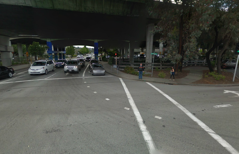
The place of the crash. Image from Google Streetview. Someone lost a daughter last week. Olga Rodriguez was killed by a driver while crossing the street in downtown San Rafael. Though her unnamed walking companion survived, he's in the hospital with serious injuries. The driver, who stayed on the scene and is cooperating fully with police, only stopped after he heard them being hit. According to him, he never saw them.

The driver was turning left from Third Street to Heatherton. From photos, it appears that he was in the inner left-turn lane where it would be harder to see anyone in the crosswalk. The truck is also quite tall, so it's entirely possible he never did see either Olga or her companion. That's a sign the intersection is broken, and the crash was likely preventable.

The fix is fairly straightforward: give pedestrians a head start when crossing (something known as a Leading Pedestrian Interval, or LPI). After the light on Heatherton turns red to southbound traffic, pedestrians crossing Heatherton would get a walk sign but Third Street would stay red. Three or four seconds later, Third Street would turn green.

Whether or not the truck driver could have seen Olga or her companion before he hit them, they would have been much harder to miss had they had a short head start. As well, rather than trust drivers to give pedestrians priority, the structure of the intersection gives priority to pedestrians instead.

The LPI isn’t just window dressing. A study by Michael King in New York City found that a pedestrian head start leads to a 12 percent reduction in crashes over the baseline or 28 percent reduction compared to unmodified intersections, which saw crashes increase by 17 percent over the course of the study. While crashes did still occur, their severity occurred declined 55 percent overall and 68 percent in comparison to unmodified intersections.*

A flashing yellow arrow would make things even more apparent. Research on yellow arrows in this situation is scant, but in situations with two-way traffic they make drivers exceptionally aware of oncoming traffic. This is precisely the kind of awareness drivers need while navigating an awkward and busy intersection like Third and Heatherton. A zebra-striped crosswalk would further raise the visibility of people crossing.

Though these kinds of changes require advanced signal hardware, it needs to be purchased anyway to tie SMART in to area’s traffic signals. It would simply be part of that purchase.

The ubiquitous pedestrian barrier is often the tool of choice for San Rafael’s public works department, but deploying it here would just give up on the intersection. It’s a vital connection to the Transit Center for commuters at the park and ride and anyone coming from east San Rafael. The area can get sketchy at night, and discouraging legitimate foot traffic will only make it sketchier. Nobody should ever fear for their lives while crossing the street, especially not in an area that’s supposed to be the heart of the county’s transit system.

We cannot erase the physical scars of Olga's companion. We cannot bring back Olga or wash her blood from the conscience of the driver who killed her. But we can honor the companion's wounds and Olga's death and make sure this never happens again.

* New York State assigns numerical values to crashes based on cost to society. Collisions with fatalities were multiplied by 2729, those whose victims were hospitalized and seriously injured were multiplied by 1214, those whose victims were hospitalized but not seriously injured were multiplied by 303, and those whose victims were injured but walked away were multiplied by 76. The total was then divided by the number of crashes.

Wider 101 onramps could be a boon for bus riders, too

Metering lights could be coming to Highway 101 in Marin as soon as 2015 and with them wider onramps. Though one wouldn’t expect this to be a boon to transit riders, this is an ideal chance for TAM to improve the county's bus pads. It should not pass it up. I wrote about the bus pad on Greater Greater Washington, an urbanist blog in Washington, DC, and commenters quickly panned it. "This falls into the 'better than nothing' category," said one. Another: "If we're calling these pads an improvement, it really should be an indictment of how low we've set the bar." Ben Ross posted a link to the piece on Twitter with his commentary:

Though most bus riders appreciate the speed of freeway-running buses, they do have a point. Crossing a freeway onramp without a crosswalk is dangerous and frightening. Transferring from a pad to a street stop can be a pain (and a trek). While the southbound bus pad might be right next to your destination, the northbound bus pad might be a half-mile slog away. And, of course, waiting at the edge of a freeway with nothing around but parking lots or low-maintenance landscaping can be exceedingly unpleasant.

We can change all that.

There are three areas where bus pads need to improve: access, comfort, and speed.

Access means improving the connections between the surface streets and the bus pads, as well as moving the two pads closer together so both directions are accessible to development near the ramps.

Caltrans redesigned the Tiburon Wye’s interchange – a “parclo” (partial cloverleaf) interchange common around Marin – to better facilitate bus pad access and transfers. The redesign, which is still on the drawing board, puts surface street and freeway bus stops as close together as possible and allows buses entering the freeway to use the pads. It is a good example of what is possible.

New Tiburon Wye

Where a redesign like Tiburon’s isn’t possible, the metering lights themselves present an opportunity to make bus pad access safer. If the metering light signal were linked to a pedestrian button, like a regular street crosswalk, a rider could simply press it and wait for a walk sign. That sounds much better than a running through a break in traffic.

For comfort, the bus pads need shade and some greenery. Landscaping, especially shade trees, would go a long way. Approaching paths need similar treatment.

Some bus pads, like the ones at Smith Ranch Road/Lucas Valley, have clear paths worn away by commuters approaching by more rational paths than the ones provided by freeway engineers. These should be formalized and upgraded with lighting, pavement, and shade.

For speed, the proposed HOV onramp lanes would help at the places where trunk line and commuter buses enter the freeway, especially downtown Novato, downtown San Rafael, Larkspur Landing, Strawberry, Manzanita and Marin City. Shaving 30 seconds off each ramp for a bus with 40 people onboard will amount to a lot of time saved.

Transit-friendly designs need to be baked in from the beginning of this process. That will allow staff to fully vet them before presentations to the governing boards and the state. The further plans get without these designs, the more difficult and expensive it will be to add them in.

This is a once-in-a-lifetime opportunity to fundamentally alter how Marin’s transit moves along the 101 corridor. Let’s prove Ben Ross and the other East Coast naysayers wrong. We can do so much better than what we have, and now we have a chance to do so.

Point of agreement: Second units are a good way to add new housing

A second unit. Image from Decker Bullock. Though the pages of this blog are often critical of the so-called “slow growth” philosophy of development stasis, its activists hold up second units as a solution to our housing crunch. While I won’t go so far as to say it is our only solution, they are certainly part of the mix.

Marin’s housing market is faced with two housing shortages. It is part of the overall shortage of housing in the region – the cause of the troubling spikes in rent in San Francisco, major displacement of the poor in Oakland, and threats to our open space in the far East Bay.

The other shortage is a local lack of small units, namely studios and one-bedrooms, in Marin. This has meant a steady increase in small-unit rents at a faster rate than either wages or the county’s rental market at large.

Second units offer a way to deal with both without dramatically altering the appearance of our neighborhoods. Though regional trends will be a far greater weight on our overall housing costs than new development, it would help solve the problems in our county’s submarket. And, for the region at large, it would allow some housing development to ease North Bay demand.

I say this is a point of agreement with slow growth because, well, they’ve said it often. Frequent TGM commentor Richard Hall certainly thinks so, with comments all over the place about it. Bob Silvestri, too, came out in favor of this strategy in his book (PDF, page 51). The IJ and Patch comments sections are rife with other examples.

My initial concern about allowing this sort of infill development was that it isn’t targeted, but actually that’s just fine. The reasons for the current ban on in-law units are familiar: traffic and parking. Planners feared that allowing second units would cause residents to park on the street (a big no-no in the 1970s) and put undue stress on the big arterial roads like Freitas Parkway and San Marin Drive.

But really, most of Marin’s mid-century sprawl and early 20th Century development is well-suited to the distances traveled by walking and biking. Shopping is typically within a half-mile, as is a bus line. There should be more than enough capacity in our neighborhoods for more small units.

To make this reality, two big changes should happen. First, the state needs to recognize second unit expansion as a viable method to expand affordable housing under its RHNA affordable housing structure. At the moment, it is not.

Second, towns and cities need to allow second units in their residential neighborhoods, preferably targeted in areas that are within walking distance of transit and shopping. Conversion of existing structures should be allowable by right, in other words buildable without more than city staff approval. New construction might go through a planning commission process, perhaps requiring approval from adjacent neighbors.

To really be affordable housing, towns and cities would need to ensure at least some units are built. To do this, they should offer incentive programs to householders who want to build the units. New buildings can be expensive to build well, and incentive programs would ensure these units are of good quality. Just lowering the permit fees could do the trick.

If the county makes it easy for these amateur landlords to take Section 8 vouchers, it would be a major boon to Marin’s affordable housing needs.

Because of the acrimony between the slow growth and smart growth factions in Marin, it’s imperative we embrace the areas where we can work together for a common goal. Second units are the area where we can, and where we must. If Republicans and Democrats can come together for a budget deal in the US House of Representatives, surely we can come together in our living rooms, pubs, and town halls.

And, since the end result would be a greater Marin, that’s something we could all celebrate.