Returning to the Flood

Last week, San Anselmo came within inches of yet another disastrous flood. Perhaps it’s time to revisit the flood detention basin issue.

Background

After the flood in 2005, a plan was put forward to build a flood detention basin in Memorial Park which would protect the downtown from floods by temporarily diverting water to the park during heavy storms. The town received a $8.72 million state grant to build the $17.2 million basin and planning work began. In 2015, voters rejected Measure E – without downtown’s support – which would have allowed the use of Memorial Park as a basin. The flood zone board is now trying to figure out what to do instead.

Support for Measure E. Image by the Author.

Of those currently on the council, Matt Brown and Ford Greene oppose the conversion of the park. Councilmember Brown led the charge to pass Measure E. In the same election he also ousted now-former council member and basin supporter Doug Kelly. Councilmember Greene has consistently sided with Marin’s populists on issues such as affordable housing, zoning reform, transit, and the flood basin. Both have appeared at Citizen Marin and associated group meetings. The rest of the council (Kay Coleman, Tom McInerney, and John Wright) supported the conversion of the park [1] and presumably still would if it were a possibility.

Councilmember Brown is certainly unmoved by last week’s close call. To quote the IJ, “Brown said he and many other San Anselmo residents wisely chose not to buy property in the floodplain. He said spending millions of dollars to address flooding in the Ross Valley would be ‘tantamount to a bailout of somebody’s real estate decision.’” He also voiced skepticism that the town should even pay for flood mitigation: “[H]ow how much are we willing to pay to put that plan into place? This is a multimillion-dollar project, one that I believe the people have to decide if it’s worth implementing.” [2]

Councilmember Greene doubts that the basin system would even make a difference but advocates instead for another basin in Fairfax and the demolition of 636 San Anselmo Avenue, which straddles the creek. [3] This is one of the proposals currently undergoing public comment.

What now?

The basin would have been part of the work plan for Flood Control District 9, the board charged with reducing flood risk in Ross Valley, but the rest of the work plan is still proceeding. This includes raising bridges in San Anselmo, Ross, and Fairfax; creating flood detention basins at Loma Alta and Lefty Gomez Field in Fairfax; creating additional storage capacity at Phoenix Lake; and improving the creek channel in Ross and Larkspur. [4] The conversion of Lefty Gomez Field has already inspired opposition. [5]

Of course, the Memorial Park basin was part of the overall flood mitigation strategy for the watershed and, with its demise, an alternative needs to be found. There are four alternatives currently before the district board, each of which costs approximately the same as the Memorial Park conversion. You can read all about them here, but the gist of them is that each would be disruptive somewhere. The No Basin Alternative involves heavy roadwork on the Sir Francis Drake Boulevard bridge. The Sleepy Hollow alternative involves a detention basin at Brookside Elementary. Councilmember Greene’s preferred alternative would involve at least partially demolishing two of downtown San Anselmo’s iconic buildings. [6]

It is a shame that downtown San Anselmo has to endure not just neglect from its neighborhoods but active opposition to its success. A town ought to be more than a commodity to be used but a community that sticks together and looks out for one another. Downtown is supposed to be the heart of that community.

Works Cited

[1] Richard Halstead, “Dueling Ballot Measures over Flood Control Divide San Anselmo,” Marin Independent Journal, September 26, 2015; Peter Seidman, “Shelter from the Storm,” Pacific Sun, May 4, 2015.

[2] Richard Halstead, “Ross Valley Flood Scare Brings Calls for Action,” Marin Independent Journal, January 13, 2017.

[3] Ibid.

[4] Marin County Department of Public Works, “FZ9 Project Fact Sheets,” Marin County Watershed Program, accessed January 18, 2017.

[5] “Save Lefty Gomez Field,” accessed January 18, 2017.

[6] Liz Lewis, “Update-Analysis of Replacement Project Alternatives for DWR Grant” (San Anselmo, CA: Flood Control Zone 9 Advisory Board, June 21, 2016).

What if the Bay Area had never lost its railroads?

With the Northwestern Pacific reopening up soon as a limited commuter rail service - even though it need not - one wonders what the Bay Area would have looked like had it reinvested in its rail lines over the years rather than just rebuilt them. Well, it probably would look something like this:

Map by Theo Ditsek. Click to go to his post, where you can find a full-size image.

Map by Theo Ditsek. Click to go to his post, where you can find a full-size image.

I am always pleased to see our region's transit system reimagined by others, but I'm especially happy to see Theo Ditsek, one of the internet's more prolific transit map hobbyists, tackle the Bay Area, and tackle it like he did. From what I can see, he didn't leave a single rail line unused: there are rail lines from West Marin to Sausalito, subways through San Francisco, commuter rail to Santa Cruz, and shuttle lines heading every which way. My favorite, though, is the railroad to Tahoe.

Perhaps my only complaint is the lack of rail links from Marin and Vallejo to San Francisco, both for commuters and long-distance travelers. Beyond this, however, it's a truly marvelous piece of work. Now if only I could get it as a poster...

Tautological housing study reminds us that demand is more than skin deep

A few weeks ago, the Wall Street Journal reported on a new study by the National Association of Home Builders which found just 10 percent of people born after 1977 want to live in the urban core; the rest want the suburbs or rural areas. The catch was that the study group was only those who had bought a house in the past three years or who plan to do so. In other words, people who want to buy a house want to live in a place where they can buy a house. But the study, an exercise in tautology if there ever was one, does add some value to the overall discussion about what today’s young homebuyers want out of a home, and the reaction to the study shines light on the foolishness of urban-vs-suburban partisanship.

What the study says

Just 10 percent of young homebuyers want to stay in the central city, while 68 percent want to move to the suburbs. These suburban homebuyers tend to buy smaller, older houses relatively close to the central city, and they put a premium on being within walking distance of amenities like restaurants, stores, schools, and transit.

This is not the typical car-oriented suburb. Rather, it’s a suburban town, the sort of place that grew up along the old streetcar lines before they vanished. It’s a place that can accommodate trips made by car, transit, biking, and walking.

It seems the same things that draw young people to cities remain valuable even when those same young people leave.

What the study leaves out

The NAHB study is a stated-preference study. In other words, it looked at what people said they wanted rather than what they actually did when presented with options, which is called a revealed preference study.

This is most clear in the disconnect between the cost of housing in a dense, walkable urban place and the cost of housing in a sprawling, drivable place. Outer-suburban and exurban homes were the first to lose their value during the Great Recession and have been the slowest to recover. Meanwhile, dense, central cities have seen the cost of housing soar, as have walkable towns near those cities.

These price signals are quite clear: the supply for outer-suburban and exurban homes exceeds demand, and the demand for central-city homes exceeds supply. Similar price stability and price spikes along transit corridors and in the old walkable streetcar suburbs shows this demand isn’t simply for central city homes but for walkable living.

More than that, the study doesn’t scratch the surface of where young people would want to live if central cities had similar prices and similar school quality to the suburbs. After all, the draw of the suburb might not even be a function of the suburban or urban form per se but a simple function of how inhospitable American cities are to raising a family.

Or perhaps it’s simply housing availability: most new housing development has been in the exurbs, and central cities have been housing laggards.

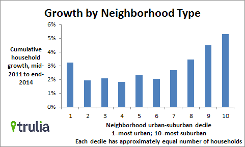
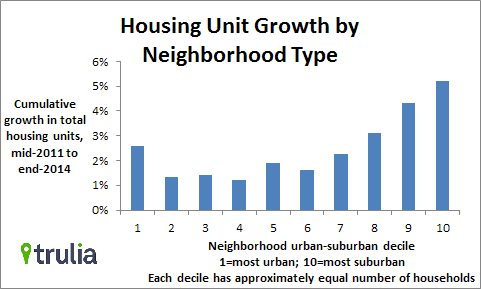
This last theory is held out by analysis by Jed Kolko of real estate analyst Trulia. Last week, he tweeted the following three charts:

Image by Jed Kolko

Image by Jed Kolko

Image by Jed Kolko

Growth in population closely matches the growth in housing units across the urban spectrum: the more homes, the more people. In fact, a read of the last two charts shows that neighborhoods are adding households faster than homes in all but the most suburban neighborhoods (deciles 9 and 10), with the most pronounced difference in urban neighborhoods (deciles 2-4). As a result, the growth in home sale price is highest outside of the most suburban neighborhoods. While the most urban neighborhoods saw their prices go up fastest, it was the least urban neighborhoods that saw their housing supply and population rise fastest.

This is due to a number of factors, but the largest is the $400 billion worth of federal subsidies (PDF) poured into the most suburban of places. Given the price rises in more urban areas, it seems as though this and state-level policies are working against the underlying demand rather than chasing demand.

It’s a stupid debate

Anti-urban partisans are always quick to crow about the end of the cities and seem eager to pounce all over any shred of evidence that might support this thesis, context be damned. Anti-suburban partisans, alas, do the same about evidence for suburban demise.

Yet being a partisan for a particular kind of urban form is nonsense. The great structural debate about housing and transit in the United States is fundamentally about whether the provision of housing in all its forms has adequately satisfied consumer demand.

The NAHB study doesn’t presage the slaughter of the city and triumph of the suburb any more than the fact that Americans aren’t driving as much presages the opposite. It presents a look at where young homebuyers say they want to live (namely, in places where they can buy homes).

What does this mean for Marin?

Young people want places that look like Marin: walkable, suburban, not too far from the city, with a decent transit network. Consumer demand surveys of all young people, not just homebuyers, found that the strong bias towards walkable living is found among renters and homebuyers alike.

The problem, of course, is that there isn’t enough San Francisco, or Marin, to go around. As I have insisted since the beginning of this blog, the demand for new homes in Marin should be channeled into enhancing and spatially expanding our downtowns.

San Anselmo, for example, has space for 79 of new apartments above stores within its downtown core. That’s 79 new families that could be living and shopping in a totally walkable environment. If downtown zoning were expanded to highway commercial zones, that’s room for dozens more new families and businesses.

Marin could push against its own struggling town centers and try to hem them in, or it could take this as an opportunity to build upon the formula that works: walkable towns adjacent to nature. There is room enough for the entire spectrum of suburban home types in Marin. We can take advantage of that demand, and build a greater Marin out of it.

The poetry of The Greater Marin

You may not know it, but The Greater Marin is on Twitter. It's fun, really, to get in touch with people who agree and disagree with me from all over the world. Follow me, if you don't already. A new tool turned all these tweets into semi-coherent poetry. The result made me smile, so I thought I might as well share.

S!@# Together

North San Jose neighborhood And design for your speed limit! That does not sounds good. Of Cut Wood. CUT WOOD, DAMMIT.)

Police, and idiot pedestrians. Buses, like the GOOG shuttles: Heh. Vegans. Urbanist world: cars uber alles.

Inane of nuances of Marin politics. With the new barrier, not less. Hearts drown performance metrics.

The county and bring up some gold. Napa, Capitol Corridor, and Marin. Not smaller. Just slower and cold.

We'll be back Monday, but if you can't wait, find me on Twitter.

New on the IJ: Housing close to transit hubs is a time-tested model

Last week, IJ columnist Dick Spotswood wrote that he had a revelation: The best ways to provide new homes in Marin are to add housing to downtowns, emulate downtown forms, and add second units. It may have been a revelation to him, but it's not news to the Coalition for a Livable Marin — CALM. We've been advocating for just such an approach since we were founded.

Spotswood wrote the foreword to Bob Silvestri's pro-sprawl manifesto, but he's starting to understand the wisdom of Marin's small, dense, rail-oriented downtowns.

Up until the 1940s, Marin was built to maximize ridership on our old light-rail system, the Interurban. Planners put high-density commercial and residential buildings right up next to stations and less-dense homes farther out.

The layout was deliberate. While people today often drive from parking space to parking space on their way home to run errands, yesteryear's Marinites would walk from shop to shop to run errands on the walk home.

People taking Golden Gate Transit can often still do that, especially at one of the downtown hubs. Take the 27 from the Financial District to San Anselmo, pop into Andronico's or Comfort's for the night's dinner, then walk home.

Most wonderful about this sort of development is how it's used when people aren't commuting. Kids can stop by the doughnut shop on a Saturday, parents can watch the street from the coffee shop, and seniors can live their days seeing neighbors and family without ever setting foot in a car.

Marin ought to encourage people to live in places like this, not just for the sake of affordable housing or greenhouse gas emissions but for the health of the town.

Continue reading on MarinIJ.com

High attrition the cause of GGT's cancellations

This morning, no fewer than 5 Golden Gate Transit buses were cancelled: 2 runs of Route 24, 2 runs of Route 54, and 1 run of Route 27. Other routes don't have email alerts, so it's unknown whether any of those were cancelled. It's also unknown whether any northbound trips will be cancelled this evening. At least we know there's a solution under way. Under the post on Golden Gate Transit's (GGT's) high cancellation rate on Route 54 and elsewhere in the system, customer service responded with an answer:

Golden Gate Transit’s goal is to never cancel trips on our routes, and we do everything possible to prevent cancellations. Unfortunately, we have fewer drivers right now due to a much higher attrition rate than expected. Because of this shortage of drivers, we have had more cancellations than we have experienced for some time. Employees are volunteering to work extra hours to minimize these disruptions in service. When Golden Gate Transit is forced to make a cancellation, we rotate routes so that one route is not harder hit than any other. We try to distribute cancellations as evenly as possible throughout our system. We encourage our customers to sign up for our rider alerts so they may get notification via email or text when there are cancellations or other service disruptions. Visit our website at http://www.goldengate.org to sign up for these alerts.

The current bus operator class graduates later this summer, with another class expected to graduate by the end of the year. Both of these classes are larger than most training classes, and will hopefully provide Golden Gate Transit the manpower it needs to prevent cancellations. We appreciate your patience while we work hard to alleviate this problem and want our riders to know that we are dedicated to bringing you reliable service.

While knowledge of the cause of the disruptions certainly doesn't make them any better or tolerable, it's good to know there is a solution in sight. Without dates we won't know when this solution is coming, of course, but I suspect that by September things will look better.

Once the situation improves, GGT must go out of its way to repair its tarnished image. A week of free trips on the effected lines would certainly help, as would some old-fashioned PR outreach. Implementing real-time arrivals would help, too.

Alas, until then, GGT commuters should keep an ear out for cancellations. Follow and report missing buses on Twitter with the #missingbus tag. Email contact@goldengate.org to sign up for text alerts for select routes - 24, 27, 54, and 76 (other routes aren't available). Keep your fellow commuter apprised.

Bus commuter schedules no longer reflect demand

Though by all accounts Golden Gate Transit's commuter bus system is quite popular, it is increasingly out of touch with the commute times of Marin's modern workforce. Marinites leave for work later, but GGT continues to operate with early-morning service. FiveThirtyEight recently took Census data and determined which metropolitan areas get to work the latest. The San Francisco metro area, of which Marin is a part, got fifth on the list, with a median arrival time of 8:17am but a 75th percentile arrival time of about 9:30am. The bottom of the range is about 7:45am.

Just after reading this, reader John Browne, a frequent rider of the last Route 18 from Kentfield, tweeted:

It turns out John Browne is right.

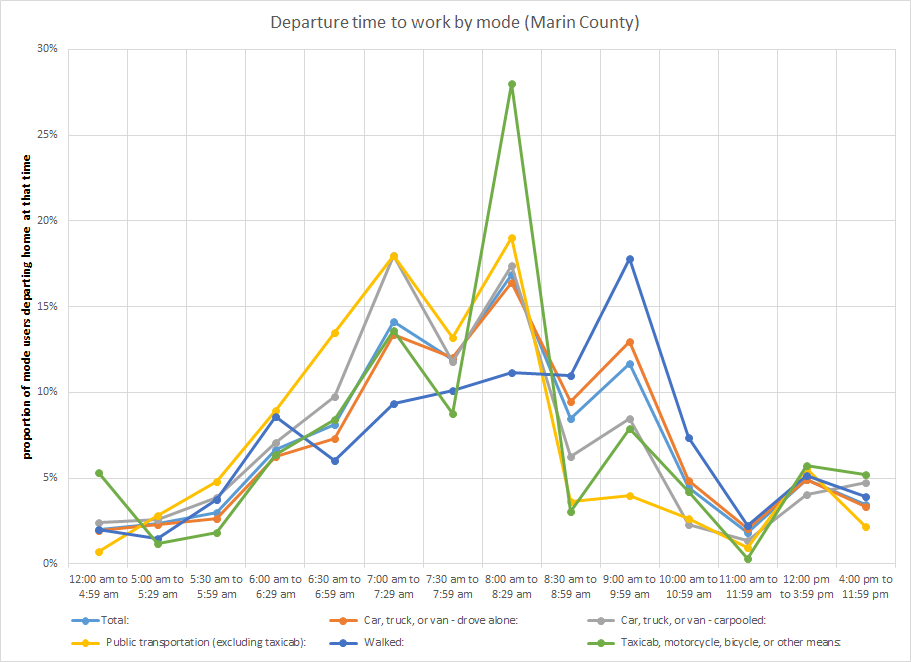
Using the same Census data FiveThirtyEight used (though without the math to convert it into the ranges author Nate Silver did), I plotted out the average departure times for Marin commuters taking all modes to work. Transit commuters leave work at roughly the same rate as others up until 9am:

Yellow is transit.

The proportion of transit riders leaving home between 9 and 10 stays down after the drop from 8:30 to 8:59 while other modes pop back up.

A glance at the span of service for Marin's commute buses makes it easy to see why that might be. On average, the last Marin stop for a Marin commuter line is about 8:27, while the average last departure is a bit earlier at 8am. In other words, if you want to get out of Marin by bus, you're probably going to have to leave home before 8 or 8:30, and that's exactly what shows up in the Census data.

GGT should reexamine the county's travel demand and which final buses are the most crowded and aim to add service to those lines later in the morning. Adding to service span will scoop up riders that want to leave later, and can also give earlier riders the peace of mind that they can leave later if needed, helping shore up ridership earlier in the morning, too.

It's not just tech workers that are leaving later in the day, it's Marinites in general. Our transit system should start scheduling for that.

Optical illusions on Fourth Street

While working on a piece about bike lanes, I stumbled across something odd that says a lot about how the built environment influences perceptions. Downtown San Rafael. Image from Google Maps.

A pet peeve of mine for years has been Fourth Street through West End in San Rafael. The neighborhood has struggled for years under the shadow of downtown, hidden just over a short hill, and street width is part of the reason I rarely spend time there. It just doesn’t feel cozy like downtown. Downtown is above this paragraph, West End is below.

San Rafael's West End

So when I got back street width data from city hall, I made a double take. Fourth Street through West End, which runs from H to E streets, was actually narrower than the rest of Fourth all the way to its end at Union, by up to 10 feet: 40 feet vs. 50 feet.

So why does it feel so much wider? Look again at the two pictures and you’ll see some stark differences. In downtown, the trees are older, the street parking is a bit fuller, and the buildings on both sides of the street cozy right up to the sidewalk. In West End, the buildings only cozy up to the sidewalk on one side of the street, with parking lots and show leading way back to squat buildings on the other side.

Those parking lots make the street appear significantly wider than it actually is, creating an optical illusion. I can’t think of a better example of how walkable development influences our sense of place better than this.

Substandard bus stops drench, humiliate riders

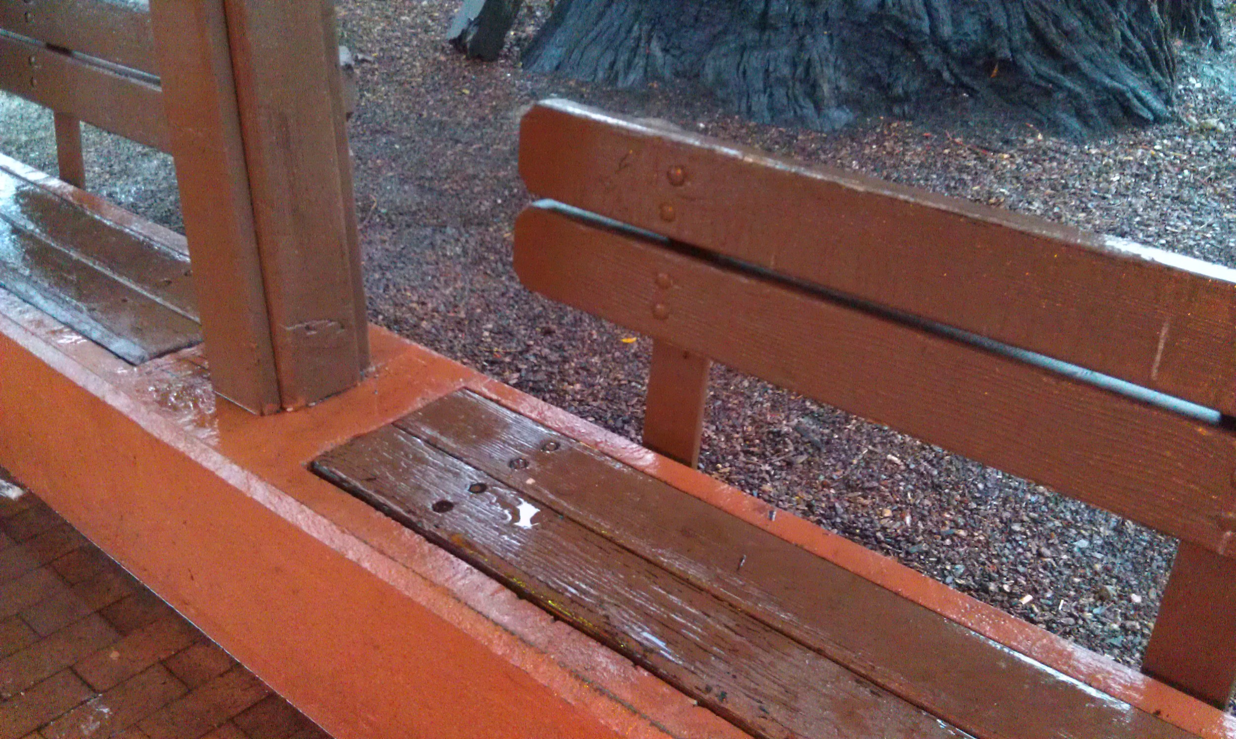
A soaked bench at the Depot. Image by the author. During Marin’s big Pineapple Express a few of weeks ago, I had the pleasure of taking the bus all over Marin. Stepping off a bus without worrying about parking or gas or finding the car always feels liberating to me, so I thoroughly enjoyed that aspect. But thanks to bad stop design, I and my fellow riders got soaked.

After chatting up some of protestors of WinCup, I walked along the narrow sidewalk to the closest southbound bus pad, not just to see what the walk was like but also because I had to get to Mill Valley. Aside from protestors using up the entire sidewalk width, forcing me to walk in the street, it wasn’t so bad. The bus pad, though, was another story.

The bus pad shelter allowed the wind to whip rain right in the face of me and my fellow travelers. The bench was so soaked that sitting would have made for a cold and soggy experience. Someone else waiting spoke very little English but pointed at the rain and the bench and laughed. "Very wet," she said, and it was quite clear she thought the situation was ridiculous. Though she was heading to Mill Valley, too, she hopped on the next bus that came (Route 36) just to get out of the wet. I decided to stick it out, though, and my Route 17 bus arrived soon enough.

Alas, the Mill Valley Depot, central bus station of this most wealthy of towns, was in even worse shape. The roof dripped everywhere, soaking not just the benches but anyone who risked standing under it without an umbrella. Water trickled in from every slat in the roof and positively poured in through the light fixture.

The state of repair on the Depot and the quality of the bus pad stops tells riders, You don’t really matter. For one of the wealthiest counties in the country and one that prides itself on being green and supporting the less fortunate, that’s unacceptable.

If buses are a travel mode of equal stature to the car or ferry, bus stops – especially signature stops like the Depot – need to be treated like it. They should be comfortable, or at least bearable. The people who ride the bus for work or out of necessity do matter.

Kickstarter to document the world's changing streets

Our streets are changing. There are more bike lanes for more bikers, better sidewalks, better streetscapes. You can see it in Fairfax near the Good Earth or any time you're in San Francisco. But how are they changing, and why? How are cities learning to finally deal with congestion and accommodate other modes of travel? Todd Drezner wants to take a look, but he needs a little help to move beyond New York City. He wants to film across the United States and even take it international.

You can watch the trailer here.

The Kickstarter fundraiser ends tomorrow at 5pm and, as of this writing, he still needs about $2,000 to make his goal of $25,000. If he doesn't make it, he gets nothing. If he does, he gets the full amount. If you're as interested in the intersection between travel and urban design, maybe you'll want to give to make sure it happens.

A counter-petition starts in Strawberry

A new petition – still small – is trying to inject some sense into the Strawberry priority development area (PDA) debate. It’s about time. The core contention of the petition is simple: the PDA is not about housing, it’s about transportation funding. To cut out the transportation funding just eliminates transportation funding, leaving any housing plans intact.

The success of Marinwood activists has been the removal of the PDA but intact housing plans. The success of North San Rafael activists was the removal of the PDA but an intact station area plan. What did they accomplish? Political victories that do nothing to advance their stated goal of downsizing housing plans.

What’s a PDA again?

As I’ve written before, a PDA, or priority development area, is a funding mechanism for a part of the region. It’s entirely voluntary and entirely without strings attached. Half of Marin’s transportation dollars must go to a PDA.

At the moment, the regional funds dedicated to PDAs are for planning, so shovels can’t go in the ground, but that just means we can start the process of building real improvements to the county’s transportation infrastructure.

What is the PDA not?

Critics, including frequent commentor on this blog Richard Hall, will point to the application process, which requires an area to have plans for more housing before it can become a PDA, to say that a PDA by definition is a housing plan.

But that’s like saying a credit card, by requiring a certain income level on the application, is income. Of course that’s ridiculous. You had your income before the card. In the same way, any housing zone or plan must be before and, therefore, separate from the PDA.

That’s why anti-housing activists have seen such failure in their stated aim of stopping housing plans.

Conflict roils Strawberry

There are two housing plans that are causing discord in Strawberry: the Seminary housing plan and the county’s housing element. Of these, the Seminary housing plan is what qualified Strawberry to become a PDA first place.

The arguments against housing are diverse but familiar – it would destroy the character of the area, add to traffic congestion and school crowding, cause crime and bring in the wrong kind of people.

Added to the mix are long-running concerns over the existing traffic. The roads in Strawberry are unsafe for anyone who isn’t in a car, especially Belvedere Drive and Tiburon Boulevard. If there are more people, the thinking goes, the problems will get even worse.

Simply put, every one of these arguments is not germane to the discussion of a PDA. Even if housing did do all these things – and, if they did, Strawberry’s high rate of rental housing would surely correlate it to having the worst crime in the county – housing plans are separate from the PDA.

Indeed, remaining within the PDA would provide money to start fixing the problems Strawberry has. Starting grants totaling $210,000 would pay for a comprehensive study of bike and pedestrian infrastructure needs in the area as well as designs for a new Tiburon Boulevard interchange.

Exceptional needs

There are serious gaps in the walking and biking infrastructure throughout Strawberry, and some of it has been the target of quite a bit of ire from local families.

Redwood Highway, Seminary Drive, Belvedere Drive and Reed Boulevard all have no consistent bike or pedestrian infrastructure. Belvedere Drive especially is a fast and dangerous road. Some segments lack sidewalks and all of it is bereft of bike lanes.

Considering that it is the principal route for kids walking from the park to the shopping center, it is an accident waiting to happen. Calming the road with more and better sidewalks and shallower turns has been on the agenda of the neighborhood for years. The PDA is the best chance to make that happen.

Tiburon Boulevard: why it matters to the rest of Marin

The interchange is the biggest project in the area. Caltrans wants to install metering lights at most interchanges up and down the 101 corridor to smooth traffic flow, especially during the evening commute. Tiburon is the start of the nightly Greenbrae corridor mess as service workers leave jobs on the peninsula and head home to Contra Costa.

With a PDA, the Tiburon interchange will be eligible for regional funding, ensuring the project will finally go forward. It would also give leverage to local needs, such as a safe bike path and sidewalk across the bridge and bus pads that don’t require riders to walk across a freeway off ramp. Caltrans has historically been quite hostile to these concerns, so any advantage in negotiating with them could go a long way.

Improving the Tiburon interchange is a project of countywide importance, as it’s key to breaking the Greenbrae Corridor jam. As well, improving that bridge would allow students to finally bike or walk to school in safety, helping ease school traffic through lower Mill Valley. Remember that traffic flow tends to drop off rapidly beyond a certain point; a drop in car travel of even a few percentage points can have enormous impact.

Time to stop fighting shadows

Citizen Marin and the (newly formed) Strawberry Community Association have done Strawberry a grave disservice by spreading myths and fear about their local PDA. Their petition is full of the patently absurd, arguing that the PDA would be a tax giveaway to developers and threaten endangered species.

It’s a glimmer of hope in this never-ending, fearful, angry debate that some people have stood up to say enough. Perhaps you’d like to sign up and join them.

An entirely preventable death in San Rafael

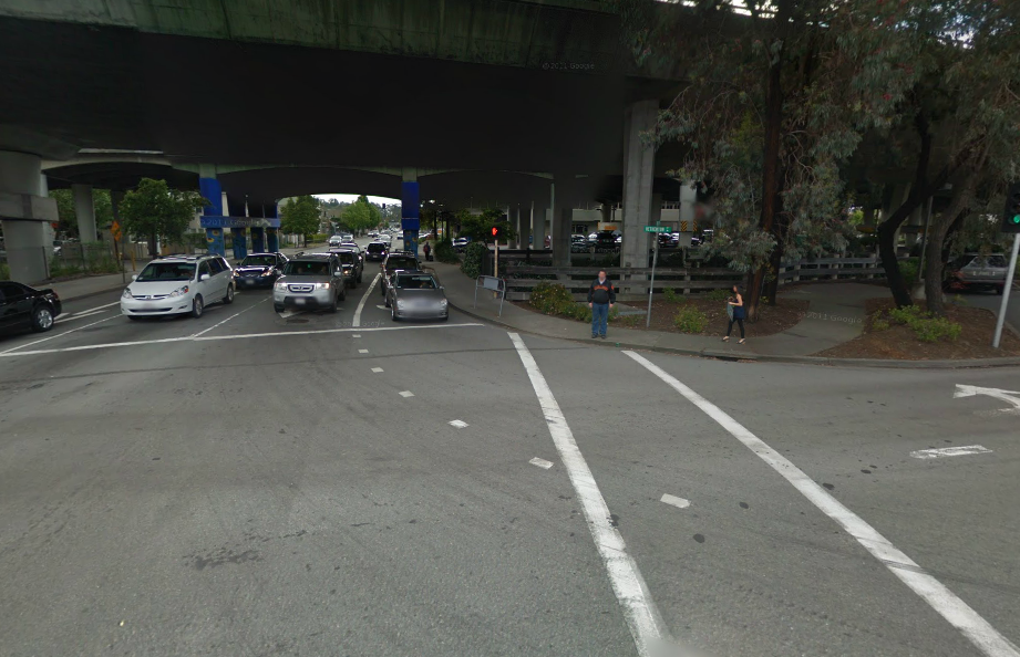
The place of the crash. Image from Google Streetview. Someone lost a daughter last week. Olga Rodriguez was killed by a driver while crossing the street in downtown San Rafael. Though her unnamed walking companion survived, he's in the hospital with serious injuries. The driver, who stayed on the scene and is cooperating fully with police, only stopped after he heard them being hit. According to him, he never saw them.

The driver was turning left from Third Street to Heatherton. From photos, it appears that he was in the inner left-turn lane where it would be harder to see anyone in the crosswalk. The truck is also quite tall, so it's entirely possible he never did see either Olga or her companion. That's a sign the intersection is broken, and the crash was likely preventable.

The fix is fairly straightforward: give pedestrians a head start when crossing (something known as a Leading Pedestrian Interval, or LPI). After the light on Heatherton turns red to southbound traffic, pedestrians crossing Heatherton would get a walk sign but Third Street would stay red. Three or four seconds later, Third Street would turn green.

Whether or not the truck driver could have seen Olga or her companion before he hit them, they would have been much harder to miss had they had a short head start. As well, rather than trust drivers to give pedestrians priority, the structure of the intersection gives priority to pedestrians instead.

The LPI isn’t just window dressing. A study by Michael King in New York City found that a pedestrian head start leads to a 12 percent reduction in crashes over the baseline or 28 percent reduction compared to unmodified intersections, which saw crashes increase by 17 percent over the course of the study. While crashes did still occur, their severity occurred declined 55 percent overall and 68 percent in comparison to unmodified intersections.*

A flashing yellow arrow would make things even more apparent. Research on yellow arrows in this situation is scant, but in situations with two-way traffic they make drivers exceptionally aware of oncoming traffic. This is precisely the kind of awareness drivers need while navigating an awkward and busy intersection like Third and Heatherton. A zebra-striped crosswalk would further raise the visibility of people crossing.

Though these kinds of changes require advanced signal hardware, it needs to be purchased anyway to tie SMART in to area’s traffic signals. It would simply be part of that purchase.

The ubiquitous pedestrian barrier is often the tool of choice for San Rafael’s public works department, but deploying it here would just give up on the intersection. It’s a vital connection to the Transit Center for commuters at the park and ride and anyone coming from east San Rafael. The area can get sketchy at night, and discouraging legitimate foot traffic will only make it sketchier. Nobody should ever fear for their lives while crossing the street, especially not in an area that’s supposed to be the heart of the county’s transit system.

We cannot erase the physical scars of Olga's companion. We cannot bring back Olga or wash her blood from the conscience of the driver who killed her. But we can honor the companion's wounds and Olga's death and make sure this never happens again.

* New York State assigns numerical values to crashes based on cost to society. Collisions with fatalities were multiplied by 2729, those whose victims were hospitalized and seriously injured were multiplied by 1214, those whose victims were hospitalized but not seriously injured were multiplied by 303, and those whose victims were injured but walked away were multiplied by 76. The total was then divided by the number of crashes.

Demand, meet supply: Lessons in housing from the DC region

Holdout by mj*laflaca, on Flickr Rising rents have led to much consternation in San Francisco. People are outraged as luxury developments displace the poor from their homes, disrupting communities and threatening the very character of the City.

SPUR caused a stir by suggesting that adding more housing could slow, or even stop, the rise. My own neoliberal "market urbanist" position has come under fire as well for suggesting market forces could be tamed by increasing supply.

Washington, DC, however, shows the concept in practice. Rising rents spurred new development, which has halted the rise in most areas and slowed it in particularly high-demand parts of town. Nearly all of this growth has been along the region’s Metrorail subway system, so rising population has not equated to rising traffic.

And, importantly for keeping urban character alive, quite a bit of this growth has occurred outside the city core, often in new urban centers in what were suburban strip-mall landscapes. To San Francisco, this has been the equivalent of tens of thousands of new housing units along the East Bay BART lines and Caltrain, and the virtual elimination of the urban strip mall.

That’s not to say DC has been immune to displacement. The once-burned-out H Street NE corridor gentrified quickly, as has Hispanic Columbia Heights. African-American Petworth and Brookland are coming under pressure from well-heeled renters, too.

But the thousands of units in the suburbs and in the city’s center have given these areas time to prepare. Affordable housing, inclusionary zoning, and various direct legislative efforts to keep people in their homes can be attempted, improved, and applied to neighborhoods that have yet to be overwhelmed. Areas without any pressure, armed with these protections, are starting to wonder when their day will come.

Anecdotally, when searching for apartments two years ago, basement units were around $950-$1,200 per month, a sharp spike from a search three years prior, before many luxury units were completed. A similar search last month saw basement units at nearly the same price, around $950-$1,300 per month in the central city.

In other words, while DC became wealthier and rents increased, the bottom of the housing market remained stable. Now even the top of the market is starting to stabilize. In fact, average rents declined 1.4 percent in DC this past year despite a rapidly growing population.

This is how the housing market is supposed to work: rents go up, people see they can make a profit, they build housing, rents stabilize and drop. This cycle is possible, and the DC region is living proof.

A version of this post appeared in Vibrant Bay Area.

Recent CEQA streamlining means stronger environmental protections

Reforms of the California Environmental Quality Act (CEQA) recently enacted will make it easier to build bike infrastructure and design our roads for people instead of cars. While touted as a “streamlining” of the law, it actually refocuses CEQA back to its original purpose: to protect California’s environment.

Level of Service

Before: CEQA requires cities to measure how a development will alter roadways’ Level of Service, an official measure of how many vehicles can be accommodated.

Why this was a problem: Level of Service doesn’t care how many people a vehicle carries, nor does it measure pedestrian or bicycle traffic also using the road. A car carrying 1 person is equal to a bus carrying 45 in the measure’s eyes. A wider sidewalk or the presence of a bike lane, which take road space away from cars, reduces Level of Service and so gets dinged in CEQA even if it might move more people along the road. In other words, by using this measure CEQA prioritizes driving over walking, biking, and transit, to the detriment of the environment.

Now: If a city wants, it can designate an area as a “transit priority area,” provided it meets certain criteria of transit service, thanks to SB 743. Instead of Level of Service, the city can use alternative measurements of road efficiency when evaluating a project. Or, it can ignore the reform entirely. The Natural Resources Defense Council's Switchboard blog has more details.

Bike lanes

Before: Like all projects, bike lanes and bike projects were required to undergo CEQA analysis.

Why this was a problem: It subjects bike projects to a costly analysis to prove biking doesn’t harm the environment. In San Francisco, plaintiffs sued the city to stop its bicycle master plan under CEQA, a counterintuitive proposal. And, with Level of Service measurements putting cars above bikes in CEQA, it forced the city to rework its bike plan to allow maximum vehicle throughput, rather than maximum usefulness for bicyclists. In the end, San Francisco’s plan was stalled for years.

Now: Under AB 417, on-road bicycle lanes that are within “urbanized areas,” though what qualifies isn’t explained in the law [see update below], as well as retiming traffic signals and adding signage, are exempt from CEQA and environmental impact reports under state law. Off-street paths aren’t included. Marin or a town could require an environmental impact report, but the state will no longer ask for it. Cyclelicious has more details on the law and what it means.

A stronger environmental law

The purpose of environmental law is to protect our environment, not to conserve the status quo. Driving is, at best, not very environmentally friendly. By removing the provisions that promote driving from environmental protection law, the reforms allow cities and counties to choose for themselves how to approach their transportation-related environmental problems. One hopes Marin’s environmentalists will jump at the opportunity.

UPDATE: Reader Eric Fischer clarified that California goes off the federal Census definition, which is any census block with 1,000 or more people per square mile as well as adjacent blocks of at least 500 people per square mile. Essentially all of developed East Marin qualifies.